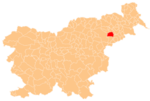
Spodnji Gaj pri Pragerskem
Appearance
Spodnji Gaj pri Pragerskem
Gaj (until 1980) | |
|---|---|
| Coordinates: 46°25′50.8″N 15°46′54.49″E / 46.430778°N 15.7818028°E | |
| Country | |
| Traditional region | Styria |
| Statistical region | Drava |
| Municipality | Kidričevo |
| Area | |
• Total | 0.22 km2 (0.08 sq mi) |
| Elevation | 239.9 m (787.1 ft) |
| Population (2002) | |
• Total | 133 |
| [1] | |
Spodnji Gaj pri Pragerskem (pronounced [ˈspoːdnji ˈɡaːi̯ pɾi ˈpɾaːɡɛɾskɛm]) is a small settlement just east of Pragersko in northeastern Slovenia. It belongs to the Municipality of Kidričevo. The area is part of the traditional region of Styria. It is now included with the rest of the municipality in the Drava Statistical Region.[2]
History
The settlement was split off from Gaj (under the designation Gaj – del 'part of Gaj')[3] in the neighboring Municipality of Slovenska Bistrica in 1980 and named Spodnji Gaj pri Pragerskem.[4][5]
References
- ^ Statistical Office of the Republic of Slovenia
- ^ Kidričevo municipal site
- ^ Milenković, Aleksandar (2007). Vzpostavitev lokalne samouprave v Republiki Sloveniji v številkah: obseg pojava "teritorialna sprememba" od leta 1971 do leta 2006, ocenjen s številom prebivalcev, administrativno preseljenih iz enega naselja v drugo. Ljubljana: Statistični urad Republike Slovenije. p. 176.
- ^ Marinković, Dragan (1991). Abecedni spisak naselja u SFRJ. Promene u sastavu i nazivima naselja za period 1948–1990. Belgrade: Savezni zavod za statistiku. pp. 30, 95.
- ^ Spremembe naselij 1948–95. 1996. Database. Ljubljana: Geografski inštitut ZRC SAZU, DZS.
External links


