Spring Hill–City View
Spring Hill
Spring Hill–City View | |
|---|---|
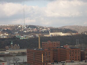
 Spring Hill (background, with radio mast), as seen from Frank Curto Park. The Cork Factory lofts in the Strip District and Troy Hill are located in the foreground. | |
 | |
| Coordinates: 40°28′01″N 79°59′38″W / 40.467°N 79.994°W | |
| Country | United States |
| State | Pennsylvania |
| County | Allegheny County |
| City | Pittsburgh |
| Area | |
• Total | 0.63 sq mi (1.6 km2) |
| Population (2010)[1] | |
• Total | 2,648 |
| • Density | 4,200/sq mi (1,600/km2) |
Spring Hill is a neighborhood on Pittsburgh, Pennsylvania's North Side. Spring Hill was named for the abundance of springs near the site.[2] According to a 1977 Neighborhood Atlas, "Germans immigrated there from 1850 to 1920, giving the neighborhood a Bavarian atmosphere. Local street names include Rhine, Woessner, Haslage, Zoller and Goehring. In 1959 ACTION-Housing opened Spring Hill Gardens, a moderate rent, racially integrated, 209-unit apartment project at Buente and Rhine Streets. Spring Hill Gardens was Pittsburgh's first multi-family housing project backed by the Federal Housing Authority." [3]
The neighborhood's population has changed over time. A 1974 report stated that the neighborhood held 8,000 people around 1970 which included nearby Spring Garden.[4] The Spring Hill neighborhood (excluding Spring Garden) declined to 4,900 in 1974 [3] and then to 2,900 in 2010.[5]
Neighborhood residents have been active for decades through the Spring Hill Civic League, which was first organized to oppose the public housing project in nearby Northview Heights and has remained active ever since.[6] This activism has helped the neighborhood to become one of the safest in all of Pittsburgh.[7][8]
| Year | Pop. | ±% |
|---|---|---|
| 1940 | 7,833 | — |
| 1950 | 7,178 | −8.4% |
| 1960 | 6,389 | −11.0% |
| 1970 | 5,275 | −17.4% |
| 1980 | 3,803 | −27.9% |
| 1990 | 3,288 | −13.5% |
| 2000 | 3,040 | −7.5% |
| 2010 | 2,648 | −12.9% |
| Source: University of Pittsburgh[9] | ||
Surrounding neighborhoods
Spring Hill-City View has six borders, five with the Pittsburgh neighborhoods of Spring Garden to the east, northeast and south, East Allegheny to the southwest, Fineview and Perry Hilltop to the west, and Northview Heights to the northeast. The other border is with Reserve Township to the north.
See also
References
- ^ a b "PGHSNAP 2010 Raw Census Data by Neighborhood". PGHSNAP Utility. Pittsburgh Department of City Planning. 2012. Retrieved 28 June 2013.
- ^ Bloom, Albert W. (Jan 14, 1953). "Pittsburgh today made up of many villages". Pittsburgh Post-Gazette. p. 23. Retrieved 2 December 2015.
- ^ a b "Spring Hill" (PDF). Pittsburgh Neighborhood Atlas. Archived from the original (PDF) on April 15, 2012.
- ^ "Spring Hill" (PDF). Neighborhood Profiles. City of Pittsburgh Urban Planning Department. Archived from the original (PDF) on April 15, 2012.
- ^ "Spring Hill" (PDF). City of Pittsburgh Neighborhood Profiles – Census 2010 Summary File. University (of Pittsburgh) Center for Urban and Social Research. Archived from the original (PDF) on September 4, 2012.
- ^ "History". Spring Hill Civic League.
- ^ "About Spring Hill".
- ^ "Spring Hill". City of Pittsburgh.
- ^ "Pittsburgh Census Tracts". pitt.libguides.com. Retrieved January 2, 2018.
External links
![]() Media related to Spring Hill–City View (Pittsburgh) at Wikimedia Commons
Media related to Spring Hill–City View (Pittsburgh) at Wikimedia Commons
