Xiangfen County
Xiangfen County
襄汾县 Hsiangfen | |
|---|---|
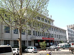
 People's Hospital | |
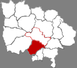
 Xiangfen in Linfen | |
 Linfen in Shanxi | |
| Country | China |
| Province | Shanxi |
| Prefecture-level city | Linfen |
| County seat | Xincheng (新城镇) |
| Area | |
• Total | 1,034 km2 (399 sq mi) |
| Population (2010)[2] | |
• Total | 442,614 |
| • Density | 430/km2 (1,100/sq mi) |
| Time zone | UTC+8 (China Standard) |
| Postal code | 041500 |
| Area code | 0357 |
| Website | www |
Xiangfen County (simplified Chinese: 襄汾县; traditional Chinese: 襄汾縣; pinyin: Xiāngfén Xiàn) is a county in the southwest of Shanxi Province, China.[1] It was established in February 1954 from the merger of the former Xiangling County (襄陵县) and Fencheng County (汾城县).[2] The county falls under the jurisdiction of the prefecture-level city of Linfen, and has an area of 1,034 km2 (399 sq mi) and has 442,614 inhabitants.[1][2]
Taosi archeological site is in Xiangfen County.
Administrative divisions
Xiangfen County has jurisdiction over seven towns and six townships.[3] These towns and townships are then further divided into 6 neighborhood committees, and 348 village committees.[2]
The county's seven towns are Xincheng, Zhaokang, Fencheng, Nanjia, Gucheng, Xiangling, and Dengzhuang.[3]
The county's six townships are Taosi Township, Yonggu Township, Jingmao Township, Xijia Township, Nanxindian Township, and Dadeng Township.[3]
Climate
| Climate data for Xiangfen, elevation 464 m (1,522 ft), (1991–2020 normals, extremes 1981–2010) | |||||||||||||
|---|---|---|---|---|---|---|---|---|---|---|---|---|---|
| Month | Jan | Feb | Mar | Apr | May | Jun | Jul | Aug | Sep | Oct | Nov | Dec | Year |
| Record high °C (°F) | 13.8 (56.8) |
21.8 (71.2) |
29.7 (85.5) |
35.8 (96.4) |
38.2 (100.8) |
39.5 (103.1) |
40.9 (105.6) |
39.7 (103.5) |
38.5 (101.3) |
31.3 (88.3) |
24.1 (75.4) |
15.1 (59.2) |
40.9 (105.6) |
| Mean daily maximum °C (°F) | 4.7 (40.5) |
9.4 (48.9) |
16.0 (60.8) |
22.8 (73.0) |
27.7 (81.9) |
32.1 (89.8) |
32.7 (90.9) |
30.8 (87.4) |
26.1 (79.0) |
20.0 (68.0) |
12.3 (54.1) |
5.8 (42.4) |
20.0 (68.1) |
| Daily mean °C (°F) | −2.0 (28.4) |
2.4 (36.3) |
8.7 (47.7) |
15.3 (59.5) |
20.5 (68.9) |
25.1 (77.2) |
26.7 (80.1) |
24.9 (76.8) |
19.8 (67.6) |
13.2 (55.8) |
5.6 (42.1) |
−0.6 (30.9) |
13.3 (55.9) |
| Mean daily minimum °C (°F) | −6.9 (19.6) |
−3.0 (26.6) |
2.6 (36.7) |
8.5 (47.3) |
13.5 (56.3) |
18.5 (65.3) |
21.5 (70.7) |
20.2 (68.4) |
14.9 (58.8) |
8.1 (46.6) |
0.8 (33.4) |
−5.2 (22.6) |
7.8 (46.0) |
| Record low °C (°F) | −19.8 (−3.6) |
−22.0 (−7.6) |
−11.0 (12.2) |
−4.1 (24.6) |
0.4 (32.7) |
7.8 (46.0) |
13.1 (55.6) |
12.2 (54.0) |
2.6 (36.7) |
−5.2 (22.6) |
−14.7 (5.5) |
−18.5 (−1.3) |
−22.0 (−7.6) |
| Average precipitation mm (inches) | 4.7 (0.19) |
7.3 (0.29) |
10.7 (0.42) |
30.2 (1.19) |
41.1 (1.62) |
58.0 (2.28) |
112.3 (4.42) |
91.1 (3.59) |
69.3 (2.73) |
41.0 (1.61) |
17.1 (0.67) |
3.4 (0.13) |
486.2 (19.14) |
| Average precipitation days (≥ 0.1 mm) | 2.4 | 3.0 | 4.1 | 5.8 | 7.5 | 8.3 | 10.0 | 8.8 | 9.3 | 6.4 | 4.6 | 2.2 | 72.4 |
| Average snowy days | 3.3 | 3.0 | 1.0 | 0.2 | 0 | 0 | 0 | 0 | 0 | 0 | 1.1 | 2.3 | 10.9 |
| Average relative humidity (%) | 57 | 55 | 51 | 52 | 55 | 56 | 68 | 73 | 73 | 71 | 67 | 60 | 62 |
| Mean monthly sunshine hours | 137.2 | 145.6 | 183.9 | 209.8 | 229.0 | 210.6 | 200.7 | 187.9 | 156.7 | 154.6 | 137.8 | 138.1 | 2,091.9 |
| Percent possible sunshine | 44 | 47 | 49 | 53 | 52 | 48 | 46 | 45 | 43 | 45 | 45 | 46 | 47 |
| Source: China Meteorological Administration[4][5] | |||||||||||||
Economy
The county has vast mineral deposits, including 2.8 billion tons of proven coal reserves, 371 million tons of gypsum, and 30 million tons of iron ore.[1] Other mined resources include dolomite, gold, silver, and copper.[1]
The county's heavy industries produce a number of industrial resources, such as coal coke, chemicals, steel, cement, and cast iron.[1] Other more complex goods such as auto parts, fitness equipment, and industrial sewing machines are also produced in Xiangfen County.[1]
Transportation
Road
The G5 Beijing–Kunming Expressway and the G22 Qingdao–Lanzhou Expressway run through the county.[1]
Rail
The Datong–Puzhou railway and the Datong–Xi'an passenger railway run through the county.[1]
See also
- Dingcun, Xincheng
- 1695 Linfen earthquake
References
- ^ a b c d e f g h i 襄汾简介 (in Chinese). Official website of Xiangfen County Government. 2017-09-29. Archived from the original on 2020-06-10. Retrieved 2020-06-10.
- ^ a b c d 襄汾县历史沿革. xzqh.org (in Chinese). 2016-11-08. Archived from the original on 2020-06-10. Retrieved 2020-06-10.
- ^ a b c 2019年统计用区划代码. www.stats.gov.cn (in Chinese). 2019. Archived from the original on 2020-06-10. Retrieved 2020-06-10.
- ^ 中国气象数据网 – WeatherBk Data (in Simplified Chinese). China Meteorological Administration. Retrieved 26 August 2023.
- ^ 中国气象数据网 (in Simplified Chinese). China Meteorological Administration. Retrieved 26 August 2023.
