Yayladere District
Appearance
Yayladere District | |
|---|---|
 Tari mountain | |
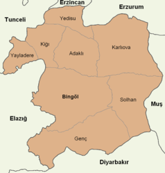
 Map showing Yayladere District in Bingöl Province | |
| Country | Turkey |
| Province | Bingöl |
| Seat | Yayladere |
| Population (2021) | 2,052 |
| Time zone | UTC+3 (TRT) |
| Website | www |
Yayladere District is a district of Bingöl Province in Turkey. The town of Yayladere is the seat and the district had a population of 2,052 in 2021.[1][2]
The district was established in 1987.[3]
Composition
Beside the town of Yayladere, the district encompasses twenty villages and seventy-three hamlets.[1]
- Alınyazı (Hozavit)
- Aydınlar (Çûx)
- Batıayaz (Murun)
- Bilekkaya (Hergep)
- Boğazköy (Aşuran)
- Çalıkağıl (Herdif)
- Çatalkaya (Gumek)
- Çayağzı (Zimtek)
- Çikan
- Dalbasan (Seter)
- Gökçedal (Deştil)
- Güneşlik (Haftariç)
- Günlük (Anzanik)
- Kalkanlı (Pargesor)
- Kırköy (Qêr)
- Korlu (Sixan)
- Sürmelikoç (Cemîzeynî)
- Yavuztaş (Taru)
- Yaylabağ (Axdat)
- Zeynelli (Zêynan)
References
- ^ a b "Türkiye Mülki İdare Bölümleri Envanteri". T.C. İçişleri Bakanlığı (in Turkish). Retrieved 19 December 2022.
- ^ "31 ARALIK 2021 TARİHLİ ADRESE DAYALI NÜFUS KAYIT SİSTEMİ (ADNKS) SONUÇLARI" (XLS). TÜİK (in Turkish). Retrieved 16 December 2022.
- ^ "İl İdaresi ve Mülki Bölümler Şube Müdürlüğü İstatistikleri - İl ve İlçe Kuruluş Tarihleri" (PDF) (in Turkish). p. 19. Retrieved 27 December 2022.


