Elappara
Elappara | |
|---|---|
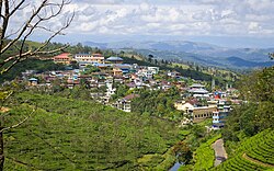
 View of Elappara town from Kattappana - Kuttikkanam road | |
Coordinates: 9°37′0″N 76°58′0″E / 9.61667°N 76.96667°E
 | |
| Country | |
| State | Kerala |
| District | Idukki |
| Taluk | Peerumedu |
| Named for | Tea plantations |
| Government | |
| • Type | Panchayati raj (India) |
| • Body | Elappara Grama Panchayath |
| Area | |
• Total | 88.48 km2 (34.16 sq mi) |
| Elevation | 1,050 m (3,440 ft) |
| Population (2011) | |
• Total | 18,714 |
| • Density | 210/km2 (550/sq mi) |
| Languages | |
| • Official | Malayalam, English[1] |
| Time zone | UTC+5:30 (IST) |
| PIN | 685501 |
| Area code | 04868 |
| Vehicle registration | KL-37 |
| Nearest towns | Kattappana, Mundakayam, Kumily |
| Lok Sabha constituency | Idukki |
| Vidhan Sabha constituency | Peerumade |
| Sex ratio | 0.98♂/♀ |
| Website | lsgkerala |
Elappara is a town in Idukki district in the southwestern Indian state of Kerala. It is one of the panchayaths in Peerumedu taluk. The area is marked by a cool climate as the region is situated at an elevation of over 1,000 m (3,300 ft) above sea level. Elappara is famous for its vast tea plantations.[2]
History
[edit]The history of present Elappara begins in 1836 with the clearing of the Vembanadu region by Henry Baker, a C.M.S. missionary. The first estate to start the tea industry in high-range was the Tyford estate and the first plantation Penshwarast - both of which are situated in Elappara panchayath.[citation needed]
During the Kollam era, the regions including Elappara were a part of the Thekkumkur kingdom and were later acquired by Manavikrama Kulasekara Perumal, the founder of the Poonjar dynasty. History says that Manavikrama was on his journey to Poonjar and took rest at 'Thangalpara,' near Kolahalamedu. Even today we can see the remnants of Minakshi idols in the rocks, indicating its history. In the 1870s, various plantations had emerged in this region. The tea cultivated here was known by the name Peerumedu hybrid tea, a type native to China. By 1896, the area was fully utilized for tea cultivation. Later, in the 1900s, the people that worked in these plantations permanently settled there.[citation needed]
Administration
[edit]Elappara panchayath was formed in 1953, including 17 wards, and it belongs to the Azhutha block of Peerumedu taluk.[3] The surrounding panchayaths are Ayyappancoil, Upputhara, Kokkayar, Peruvanthanam, and Kumily.
Wards in Elappara panchayath
[edit]- Pullikkanam
- Uluppooni
- Kottamala
- Vattapathal
- Kochu Karumtharuvi
- Chemmannu
- Chinnar
- Vallakkadavu
- Haileyburia
- Kizhakke puthuval
- Kozhikkanam
- Thannikanam
- Elappara
- Tyford
- Bonami
- Kolahalamedu
- Vagamon
Economy
[edit]Elappara is predominantly a plantation township with its abundant tea plantations. Most people work in plantations. This hill area is known for the Elappara Tea estate and its brand MASCO. Kerala's main agricultural products are cultivated in this region. Elappara is surrounded by tea estates namely the Tyford Tea Ltd, MMJ Plantations, Haileyburia Tea Estates Ltd., etc.
Religion
[edit]The majority of the population is Hindu, Christian, or Muslim. Important pilgrim centers are the Luther Mission Church at Bonami, the Uppukulam Shree Krishna Swami Temple, and the Muhiyudeen Juma Masjid.
Muslims are a comparatively smaller part of the population.
Tourism
[edit]The natural environment and landscapes of Elappara attract visitors. There are panoramic views from the roads leading from Elappara to Kuttikkanam and Vagamon.[4] The Annan Thambi and Pullikkanan hills, meadows at Kolahalamedu, scenic Vedikuzhi, Elappara streams, and the numerous tea plantations are the main attractions for the visitors.[5] Vagamon, a hill station in Idukki, is just 15 km from Elappara. The Periyar Wildlife Sanctuary and Mullaperiyar dam is situated near to this panchayath.
Transportation
[edit]Elappara is located on the Kattappana - Kuttikkanam state highway, situated about 8 km (5.0 mi) from Kuttikkanam and 32 km (20 mi) from Kattappana. Major long route buses to Kottayam and Changanassery stop here. Bus services are also available to places like Vandiperiyar, Kumily, Vagamon, Erattupetta, and Pala regions.
Demographics
[edit]As of 2011 Census, Elappara had a population of 18,714 with 9,284 males and 9,430 females. Elappara village has an area of 88.48 km2 (34.16 sq mi) with 4,754 families residing in it. The average sex ratio was 1016 lower than the state average of 1084. In Elappara, 8.8% of the population was under 6 years of age. Elappara had an average literacy of 89.6% higher than the national average of 74% and lower than the state average of 94%.[6]
See also
[edit]References
[edit]- ^ "Table C-16 Population by Mother Tongue: Kerala". www.censusindia.gov.in. Registrar General and Census Commissioner of India.
- ^ "Census of India: Villages with population 5000 & above". Registrar General & Census Commissioner, India. Archived from the original on 8 December 2008. Retrieved 10 December 2008.
{{cite web}}: CS1 maint: others (link) - ^ Keralam, Digital. "Elappara Grama Panchayath Elappara Idukki Kerala India". Digital Keralam. Retrieved 16 June 2023.
- ^ "കുട്ടിക്കാനം - ചപ്പാത്ത് റോഡ് തിളങ്ങും; മലയോര ഹൈവേ വികസന പദ്ധതിയുടെ വിശേഷം പങ്കുവച്ച് മന്ത്രി". Samayam Malayalam (in Malayalam). Retrieved 16 June 2023.
- ^ "Take a refreshing trip to the heady Elappara village in Idukki". OnManorama. Retrieved 16 June 2023.
- ^ Kerala, Directorate of Census Operations. District Census Handbook, Idukki (PDF). Thiruvananthapuram: Directorate of Census Operations, Kerala. p. 70,71. Retrieved 14 July 2020.


