File:Aerial-SantaBarbaraCA10-28-08.jpg
Appearance
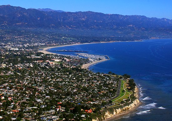
Aerial-SantaBarbaraCA10-28-08.jpg (550 × 387 pixels, file size: 74 KB, MIME type: image/jpeg)
File history
Click on a date/time to view the file as it appeared at that time.
| Date/Time | Thumbnail | Dimensions | User | Comment | |
|---|---|---|---|---|---|
| current | 02:22, 29 January 2009 |  | 550 × 387 (74 KB) | Jw4nvc | == Summary == Aerial photo of Santa Barbara, California (USA) taken 1pm 10/28/08 from about 350m altitude looking toward the Northeast. In the foreground is Shoreline Park and the edge of The Mesa neighborhood. Just beyond is Ledbetter Beach and SBCC. The |
| 08:51, 2 January 2009 |  | 550 × 625 (119 KB) | Jw4nvc | Aerial photo of Santa Barbara, California (USA) taken 1pm 10/28/08 from about 350m altitude looking toward the Northeast. In the foreground is Shoreline Park and the edge of The Mesa neighborhood. Just beyond is Ledbetter Beach and SBCC. The harbor is nex |
File usage
The following 6 pages use this file:
Global file usage
The following other wikis use this file:
- Usage on af.wikipedia.org
- Usage on ang.wikipedia.org
- Usage on an.wikipedia.org
- Usage on ar.wikipedia.org
- Usage on arz.wikipedia.org
- Usage on azb.wikipedia.org
- Usage on az.wikipedia.org
- Usage on be.wikipedia.org
- Usage on ca.wikipedia.org
- Usage on ceb.wikipedia.org
- Usage on ce.wikipedia.org
- Usage on crh.wikipedia.org
- Usage on cy.wikipedia.org
- Usage on dag.wikipedia.org
- Usage on da.wikipedia.org
- Usage on de.wikipedia.org
- Usage on de.wikivoyage.org
- Usage on el.wikipedia.org
- Usage on en.wikivoyage.org
- Usage on eo.wikipedia.org
- Usage on es.wikipedia.org
- Usage on et.wikipedia.org
- Usage on eu.wikipedia.org
- Usage on fa.wikipedia.org
- Usage on fi.wikipedia.org
- Usage on fr.wikipedia.org
- Usage on fr.wikivoyage.org
View more global usage of this file.


