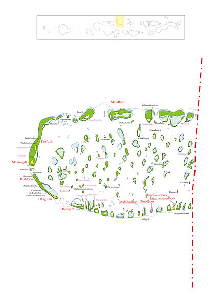
File:Alif Dhaal Atoll.jpg
Appearance

Size of this preview: 424 × 600 pixels. Other resolutions: 170 × 240 pixels | 339 × 480 pixels | 543 × 768 pixels | 724 × 1,024 pixels | 1,448 × 2,048 pixels | 2,976 × 4,208 pixels.
Original file (2,976 × 4,208 pixels, file size: 2.15 MB, MIME type: image/jpeg)
File history
Click on a date/time to view the file as it appeared at that time.
| Date/Time | Thumbnail | Dimensions | User | Comment | |
|---|---|---|---|---|---|
| current | 13:48, 19 March 2014 |  | 2,976 × 4,208 (2.15 MB) | Rotatebot | Bot: Image rotated by 90° |
| 17:36, 26 November 2005 |  | 4,208 × 2,982 (2.15 MB) | Snowdog | Map of Alif Dhaal Atoll Map originally vector'ed by Hassan Waheed, Aabaadhuge of Thinadhoo]] island. '''''Note:''' This section of map was extracted and its text was romanized by Oblivious. Special assitance by [[:en:User:Wadd |
File usage
The following 3 pages use this file:
Global file usage
The following other wikis use this file:
- Usage on ceb.wikipedia.org
- Usage on cs.wikipedia.org
- Usage on de.wikipedia.org
- Usage on es.wikipedia.org
- Usage on fa.wikipedia.org
- Usage on fr.wikipedia.org
- Usage on id.wikipedia.org
- Usage on it.wikipedia.org
- Usage on nl.wikipedia.org
- Alif Dhaal-atol
- Angaagaa
- Ariadhoo
- Athurugau
- Bodukaashihuraa
- Bulhaaholhi
- Dhehasanulunboihuraa
- Dhiddhoofinolhu
- Finolhu
- Heenfaru
- Hiyafushi
- Hukurudhoo
- Hurasdhoo
- Huruelhi
- Huvahendhoo
- Kalhuhandhihuraa
- Maafushivaru
- Machchafushi
- Mirihi
- Moofushi
- Nalaguraidhoo
- Rahddhiggaa
- Rangali
- Rangalifinolhu
- Rashukolhuhuraa
- Theluveligaa
- Tholhifushi
- Thundufushi
- Vakarufalhi
- Vilamendhoo
- Villinglivaru
- Alikoirah (Alif Dhaal-atol)
- Bodufinolhu (Alifu Dhaal-atol)
- Dhiffushi (Alifu Dhaal-atol)
View more global usage of this file.


