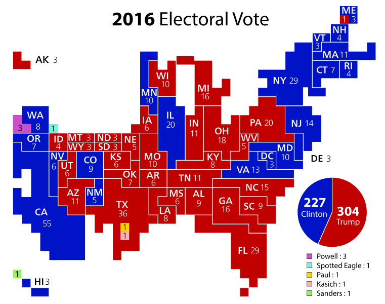
File:Cartogram—2016 Electoral Vote.svg
Appearance

Size of this PNG preview of this SVG file: 761 × 599 pixels. Other resolutions: 305 × 240 pixels | 609 × 480 pixels | 975 × 768 pixels | 1,280 × 1,008 pixels | 2,560 × 2,017 pixels | 1,272 × 1,002 pixels.
Original file (SVG file, nominally 1,272 × 1,002 pixels, file size: 146 KB)
File history
Click on a date/time to view the file as it appeared at that time.
| Date/Time | Thumbnail | Dimensions | User | Comment | |
|---|---|---|---|---|---|
| current | 23:57, 6 February 2024 |  | 1,272 × 1,002 (146 KB) | Cmglee | Make the Upper Peninsula of Michigan adjacent to WI as per https://commons.wikimedia.org/enwiki/w/index.php?title=File_talk:Cartogram%E2%80%942016_Electoral_Vote.svg&oldid=444087943 // Editing SVG source code using c:User:Rillke/SVGedit.js |
| 09:50, 6 February 2024 |  | 1,272 × 1,002 (146 KB) | Cmglee | Make NY contiguous as per https://commons.wikimedia.org/enwiki/w/index.php?title=File_talk:Cartogram%E2%80%942016_Electoral_Vote.svg&oldid=444087943 // Editing SVG source code using c:User:Rillke/SVGedit.js | |
| 09:40, 6 February 2024 |  | 1,272 × 1,002 (146 KB) | Cmglee | Disambiguate whether two blocks belong to WI or MI // Editing SVG source code using c:User:Rillke/SVGedit.js | |
| 06:48, 3 January 2017 |  | 1,272 × 1,002 (148 KB) | Oganesson007 | outline | |
| 06:46, 3 January 2017 |  | 1,272 × 1,002 (128 KB) | Oganesson007 | update | |
| 23:06, 10 November 2016 |  | 1,272 × 1,002 (128 KB) | Oganesson007 | ME | |
| 23:35, 9 November 2016 |  | 1,272 × 1,002 (126 KB) | Oganesson007 | Outline | |
| 23:34, 9 November 2016 |  | 1,272 × 1,002 (116 KB) | Oganesson007 | Final | |
| 01:14, 9 November 2016 |  | 1,272 × 1,002 (110 KB) | Oganesson007 | update | |
| 05:49, 10 April 2016 |  | 1,272 × 1,002 (101 KB) | Oganesson007 | User created page with UploadWizard |
File usage
The following 3 pages use this file:
Global file usage
The following other wikis use this file:
- Usage on bg.wikipedia.org
- Usage on ca.wikipedia.org
- Usage on es.wikipedia.org
- Usage on fa.wikipedia.org
- Usage on hu.wikipedia.org
- Usage on it.wikipedia.org
- Usage on mk.wikipedia.org
- Usage on ms.wikipedia.org
- Usage on pa.wikipedia.org
- Usage on pnb.wikipedia.org
- Usage on ru.wikipedia.org
- Usage on sh.wikipedia.org
- Usage on sr.wikipedia.org
- Usage on uz.wikipedia.org


