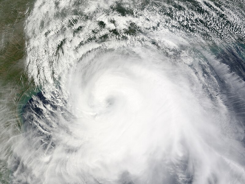
File:Ike 2008-09-12 1705Z.jpg
Appearance

Size of this preview: 800 × 600 pixels. Other resolutions: 320 × 240 pixels | 640 × 480 pixels | 1,024 × 768 pixels | 1,280 × 960 pixels | 2,560 × 1,920 pixels | 5,400 × 4,050 pixels.
Original file (5,400 × 4,050 pixels, file size: 4.57 MB, MIME type: image/jpeg)
File history
Click on a date/time to view the file as it appeared at that time.
| Date/Time | Thumbnail | Dimensions | User | Comment | |
|---|---|---|---|---|---|
| current | 17:20, 18 September 2008 |  | 5,400 × 4,050 (4.57 MB) | Ramisses | OOps! Wrong image. |
| 17:12, 18 September 2008 |  | 4,400 × 4,400 (3.96 MB) | Ramisses | {{Information |Description=Hurricane Ike over Gulf of Mexico. Hurricane Ike was a strong Category 2 storm when the Moderate Resolution Imaging Spectroradiometer (MODIS) on NASA’s Terra satellite captured this image at 12:05 p.m. C |
File usage
The following 34 pages use this file:
- User:Bob rulz/Hurricane Herald
- User:WindRunner/WPTC newsletters
- User:Yellow Evan/Arcive 2
- User talk:Ajm81
- User talk:Appleworm
- User talk:AstroHurricane001/Archive 25
- User talk:AySz88
- User talk:Bladeswin
- User talk:Cyclonebiskit/Archive2
- User talk:Dr Denim
- User talk:Ev-Man
- User talk:Fableheroesguild
- User talk:Hmich176/Archive 3
- User talk:Hurricane-Inu
- User talk:Icelandic Hurricane/Recent Archive
- User talk:IrfanFaiz/Archive/Archive No.2
- User talk:Iune/Archive 3
- User talk:Jamie C
- User talk:Juan andrés
- User talk:Maverick423
- User talk:Nightstallion/τ
- User talk:Patricknoddynewaccount
- User talk:Pobbie Rarr
- User talk:Robomaeyhem/Archive 6
- User talk:Sarsaparilla39
- User talk:Sd31415/October 2008
- User talk:TheNobleSith
- User talk:The Grid/Archive 4
- User talk:Typhoonchaser
- User talk:Verrai/Archive11/Archive10
- User talk:WeatherVane
- User talk:WmE
- User talk:Yellow Evan/Archive 1
- Wikipedia:WikiProject Tropical cyclones/Newsletter/Archive 21
Global file usage
The following other wikis use this file:
- Usage on de.wikipedia.org
- Usage on fr.wikipedia.org


