File:Irma 2017-09-10 1315Z.jpg

Original file (2,466 × 2,466 pixels, file size: 3.78 MB, MIME type: image/jpeg)
| This is a file from the Wikimedia Commons. Information from its description page there is shown below. Commons is a freely licensed media file repository. You can help. |
Summary
| DescriptionIrma 2017-09-10 1315Z.jpg |
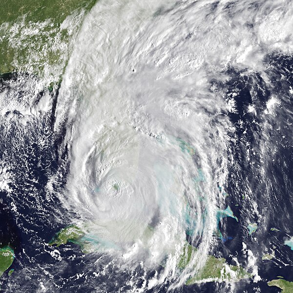
English: After battering Cuba and several Caribbean islands for most of a week as it crept slowly northwestward, Hurricane Irma turned north into Florida on September 10, 2017. Heavy rain and hurricane-force winds battered both the east and west coasts of southern Florida, even though the eye of the monstrous storm made landfall in the southwestern part of the state. Seas were rising with storm surges as far north as Charleston, South Carolina.
Hurricane Irma made its first U.S. landfall on Cudjoe Key, Florida, about 30 miles east of Key West, around 9 a.m. on September 10. The storm was rated as a category 4, with sustained winds of 130 miles per hour at the time. It made its second landfall at Marco Island around 3:30 p.m. with similarly potent winds. At 5 p.m. Eastern Daylight Time, the National Hurricane Center reported that Irma was over Naples, Florida, bringing sustained winds of 110 miles (180 kilometer) per hour, with gusts to 140 miles per hour. Hurricane-force winds extended 80 miles (130 kilometers) from the center of the storm; tropical storm winds stretched at least 220 miles (350 kilometers), wider than the state from west to east. The storm was moving north at 14 miles (22 kilometers) per hour. It was expected to hug the west coast of Florida through Monday morning. Geostationary Operational Environmental Satellite 13 (GOES-13) acquired data for the composite image above at 8:15 a.m. on September 10 as the storm was passing over the Florida Keys. Infrared data (band 4) is overlaid on a MODIS blue marble. The satellite is operated by the National Oceanic and Atmospheric Administration (NOAA), while NASA helps develop and launch the GOES series of satellites. The second, natural-color image was acquired at 10:50 a.m. local time by the Moderate Resolution Imaging Spectroradiometer (MODIS) on NASA’s Terra satellite. Though much popular interest focuses on the winds and rain of a hurricane, storm surges are often the most deadly part of such an event. National Weather Service (NWS) forecasters warned of dangerous storm surges from the Florida Keys to Tampa Bay. Forecasters predicted waters as high as 10 feet (3 meters) above normal in places. The western shore is known for its relatively shallow coastal waters, and many neighborhoods are carved into lagoons and canals near the shore. “This is a life-threatening situation,” NWS declared. Irma has been churning at hurricane force since August 31, and it has been a major hurricane—category 3 or above—for nearly all of that time. |
| Date | |
| Source | https://earthobservatory.nasa.gov/images/90948/hurricane-irma-strikes-florida |
| Author | NASA Earth Observatory images by Joshua Stevens, using data from the NASA-NOAA GOES project and LANCE/EOSDIS Rapid Response. Story by Mike Carlowicz. |
| Other versions |
|
Licensing
| Public domainPublic domainfalsefalse |
| This file is in the public domain in the United States because it was solely created by NASA. NASA copyright policy states that "NASA material is not protected by copyright unless noted". (See Template:PD-USGov, NASA copyright policy page or JPL Image Use Policy.) |  | |
 |
Warnings:
|
Captions
Items portrayed in this file
depicts
10 September 2017
File history
Click on a date/time to view the file as it appeared at that time.
| Date/Time | Thumbnail | Dimensions | User | Comment | |
|---|---|---|---|---|---|
| current | 09:41, 27 October 2017 |  | 2,466 × 2,466 (3.78 MB) | A1Cafel | Original size |
| 10:10, 19 September 2017 |  | 720 × 480 (391 KB) | A1Cafel | User created page with UploadWizard |
File usage
Metadata
This file contains additional information, probably added from the digital camera or scanner used to create or digitize it.
If the file has been modified from its original state, some details may not fully reflect the modified file.
| Software used | Adobe Photoshop CC 2017 (Windows) |
|---|

