Jump to content

File:JNBellinMap1744MississippiLaBalize.jpg

Page contents not supported in other languages.
This is a file from the Wikimedia Commons
From Wikipedia, the free encyclopedia

JNBellinMap1744MississippiLaBalize.jpg (600 × 403 pixels, file size: 106 KB, MIME type: image/jpeg)

Summary

Description
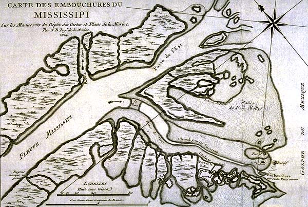
English: 1744 map of the Gulf East Pass mouth of the Mississippi River, with the town of La Balize shown. "Carte des Embouchures du Mississipi (sic) [Map of Entrances to the Mississippi River]".
Date
Source

18th century map, Published 1744 by Veuve Ganeau, Paris.

Sur les Manuscrits du Dépôt des Cartes et Plans de la Marine, via Louisiana State Museum site at [1]
Author Map by Jacques Nicolas Bellin, engraved by Guillaume Dheulland

Licensing

Public domain

This work is in the public domain in its country of origin and other countries and areas where the copyright term is the author's life plus 100 years or fewer.


This work is in the public domain in the United States because it was published (or registered with the U.S. Copyright Office) before January 1, 1929.

This file has been identified as being free of known restrictions under copyright law, including all related and neighboring rights.

Captions

Add a one-line explanation of what this file represents

Items portrayed in this file

depicts

File history

Click on a date/time to view the file as it appeared at that time.

Date/TimeThumbnailDimensionsUserComment
current12:17, 8 July 2008Thumbnail for version as of 12:17, 8 July 2008600 × 403 (106 KB)Infrogmation{{Information |Description= 1744 map of the Gulf East Pass mouth of the Mississippi River, with the town of La Balize shown. "Carte des Embouchures du Mississipi (sic) [Map of Entrances to the Mississippi River]" |Source= 18th century map, Published 1744

The following page uses this file:

Global file usage

The following other wikis use this file:

Metadata