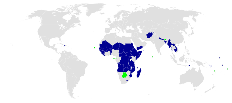
File:Least Developed Countries map.svg
Appearance

Size of this PNG preview of this SVG file: 800 × 354 pixels. Other resolutions: 320 × 142 pixels | 640 × 284 pixels | 1,024 × 454 pixels | 1,280 × 567 pixels | 2,560 × 1,134 pixels.
Original file (SVG file, nominally 2,560 × 1,134 pixels, file size: 1.01 MB)
File history
Click on a date/time to view the file as it appeared at that time.
| Date/Time | Thumbnail | Dimensions | User | Comment | |
|---|---|---|---|---|---|
| current | 11:31, 14 December 2024 |  | 2,560 × 1,134 (1.01 MB) | Ydecreux | Sao Tome and Principe graduation |
| 08:45, 14 December 2023 |  | 2,560 × 1,134 (1.01 MB) | Ydecreux | Bhutan graduation | |
| 06:56, 4 December 2020 |  | 2,560 × 1,134 (1.01 MB) | Ydecreux | Vanuatu graduation. | |
| 05:09, 19 February 2018 |  | 2,560 × 1,134 (1.01 MB) | Gabbe | updated to reflect status of Equitorial Guinea | |
| 19:12, 1 May 2017 |  | 940 × 415 (1.49 MB) | Boldair | former states in green | |
| 09:31, 7 August 2016 |  | 940 × 415 (1.45 MB) | Gabbe | added South Sudan as a distinct entity | |
| 09:24, 7 August 2016 |  | 2,560 × 1,314 (1.55 MB) | Gabbe | Added South Sudan as separate entity | |
| 11:27, 9 August 2015 |  | 940 × 415 (1.46 MB) | This, that and the other | Remove Maldives and Samoa; they are no longer LDCs. The map doesn't yet account for independence of South Sudan | |
| 21:51, 31 July 2013 |  | 940 × 415 (1.46 MB) | Kohelet | Reverted to version as of 15:09, 5 March 2013 - PNG's New Britain is falsely shown as a least developed country | |
| 20:37, 3 April 2013 |  | 940 × 415 (1.53 MB) | Hel-hama | borders widened to help see nations properly |
File usage
The following 2 pages use this file:
Global file usage
The following other wikis use this file:
- Usage on ar.wikipedia.org
- Usage on bg.wikipedia.org
- Usage on bn.wikipedia.org
- Usage on ca.wikipedia.org
- Usage on cs.wikipedia.org
- Usage on de.wikipedia.org
- Usage on eo.wikipedia.org
- Usage on es.wikipedia.org
- Usage on et.wikipedia.org
- Usage on eu.wikipedia.org
- Usage on fa.wikipedia.org
- Usage on fr.wikipedia.org
- Usage on hi.wikipedia.org
- Usage on hu.wikipedia.org
- Usage on hy.wikipedia.org
- Usage on id.wikipedia.org
- Usage on is.wikipedia.org
- Usage on it.wikipedia.org
- Usage on ja.wikipedia.org
- Usage on kk.wikipedia.org
- Usage on mk.wikipedia.org
- Usage on nl.wikipedia.org
- Usage on no.wikipedia.org
- Usage on pl.wikipedia.org
- Usage on pt.wikipedia.org
- Usage on ru.wikipedia.org
View more global usage of this file.
