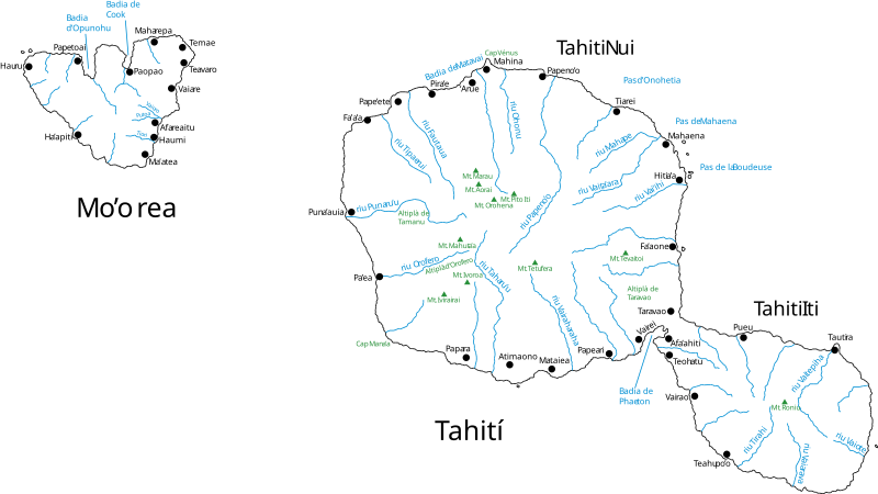
File:Mapa de Tahiti.svg
Appearance

Size of this PNG preview of this SVG file: 800 × 450 pixels. Other resolutions: 320 × 180 pixels | 640 × 360 pixels | 1,024 × 575 pixels | 1,280 × 719 pixels | 2,560 × 1,439 pixels | 1,016 × 571 pixels.
Original file (SVG file, nominally 1,016 × 571 pixels, file size: 429 KB)
File history
Click on a date/time to view the file as it appeared at that time.
| Date/Time | Thumbnail | Dimensions | User | Comment | |
|---|---|---|---|---|---|
| current | 14:22, 11 March 2007 |  | 1,016 × 571 (429 KB) | Vilallonga | |
| 11:50, 16 February 2007 |  | 1,016 × 571 (399 KB) | Vilallonga | {{Information |Description={{en|Map of Tahiti & Mo’orea. Text in catalan.}}{{fr|Carte de Tahiti et Mo’orea. Texte en catalan.}}{{ca|Mapa de Tahití i Mo’orea. Text en català}} |Source=Own Work |Date=16-02-2007 |Author=[[User:Vilallonga|Vilallon |
File usage
No pages on the English Wikipedia use this file (pages on other projects are not listed).
Global file usage
The following other wikis use this file:
- Usage on af.wikipedia.org
- Usage on als.wikipedia.org
- Usage on de.wikipedia.org
- Usage on el.wikipedia.org
- Usage on frr.wikipedia.org
- Usage on fr.wikipedia.org
- Usage on io.wikipedia.org
- Usage on ja.wikipedia.org
- Usage on oc.wikipedia.org
- Usage on pl.wikipedia.org
- Usage on ru.wikipedia.org
- Usage on ty.wikipedia.org
- Usage on uk.wikipedia.org

