Jump to content

File:PIA20188-Ceres-DwarfPlanet-Dawn-4thMapOrbit-LAMO-image5-20151210e-color.jpg

Page contents not supported in other languages.
This is a file from the Wikimedia Commons
From Wikipedia, the free encyclopedia

Original file (1,024 × 1,024 pixels, file size: 304 KB, MIME type: image/jpeg)

Summary

Description
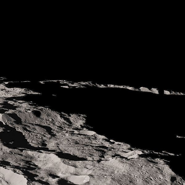
English: PIA20188: Dawn's Lowest Orbit: Near South Pole - Image 5/Image e

http://photojournal.jpl.nasa.gov/catalog/PIA20188

This view of Ceres, taken by NASA's Dawn spacecraft on December 10, 2015 shows an area in southern hemisphere of the dwarf planet. It is located at approximately 85.6 south longitude (latitude?), 176.6 east longitude.

This part of Ceres, near the south pole, has such long shadows because, from the perspective of this location, the sun is near the horizon. At the time this image was taken, the sun was 4 degrees north of the equator. If you were standing this close to Ceres' south pole, the sun would never get high in the sky during the course of a nine-hour Cerean day.

The spacecraft took this image in its low-altitude mapping orbit from an approximate distance of 240 miles (385 kilometers) from Ceres.

Dawn's mission is managed by JPL for NASA's Science Mission Directorate in Washington. Dawn is a project of the directorate's Discovery Program, managed by NASA's Marshall Space Flight Center in Huntsville, Alabama. UCLA is responsible for overall Dawn mission science. Orbital ATK, Inc., in Dulles, Virginia, designed and built the spacecraft. The German Aerospace Center, the Max Planck Institute for Solar System Research, the Italian Space Agency and the Italian National Astrophysical Institute are international partners on the mission team. For a complete list of acknowledgments, see http://dawn.jpl.nasa.gov/mission.

For more information about the Dawn mission, visit http://dawn.jpl.nasa.gov.
Date
Source http://photojournal.jpl.nasa.gov/jpeg/PIA20188.jpg
Author NASA/JPL-Caltech/UCLA/MPS/DLR/IDA
This is a retouched picture, which means that it has been digitally altered from its original version. Modifications: Colored from File:CeresSurfaceInColor.jpg. The original can be viewed here: PIA20188-Ceres-DwarfPlanet-Dawn-4thMapOrbit-LAMO-image5-20151210e.jpg. Modifications made by PlanetUser.

Licensing

Public domain This file is in the public domain in the United States because it was solely created by NASA. NASA copyright policy states that "NASA material is not protected by copyright unless noted". (See Template:PD-USGov, NASA copyright policy page or JPL Image Use Policy.)
Warnings:

Captions

Add a one-line explanation of what this file represents

Items portrayed in this file

depicts

10 December 2015

File history

Click on a date/time to view the file as it appeared at that time.

Date/TimeThumbnailDimensionsUserComment
current00:08, 27 August 2016Thumbnail for version as of 00:08, 27 August 20161,024 × 1,024 (304 KB)PlanetUser=={{int:filedesc}}== {{Information |description={{en|1=PIA20188: Dawn's Lowest Orbit: Near South Pole - Image 5/Image e http://photojournal.jpl.nasa.gov/catalog/PIA20188 This view of Ceres, taken by NASA's Dawn spacecraft on December 10, 2015 shows a...
No pages on the English Wikipedia use this file (pages on other projects are not listed).

Global file usage

The following other wikis use this file:

Metadata