Jump to content

File:Palazzo Chiericati (Vicenza).jpg

Page contents not supported in other languages.
This is a file from the Wikimedia Commons
From Wikipedia, the free encyclopedia

Original file (7,107 × 4,674 pixels, file size: 20.66 MB, MIME type: image/jpeg)

Summary

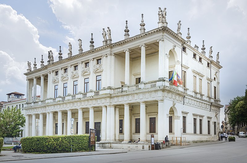
Palazzo Chiericati (Vicenza) - facade on piazza Matteotti


VI seal

This image has been assessed under the valued image criteria and is considered the most valued image on Commons within the scope: Palazzo Chiericati (Vicenza) - facade on piazza Matteotti. You can see its nomination here.

Description
English: Palazzo Chiericati is a Renaissance palace in Vicenza (northern Italy), designed by Andrea Palladio. Houses the civic gallery, which includes collections of prints, drawings, numismatics, medieval and modern statues.
Français : Le palais Chiericati est une résidence urbaine de la Renaissance d'Andrea Palladio, située à Vicence, en Vénétie. Il abrite aujourd'hui la pinacoteca civica, qui comprend des collections d'estampes, de dessins, de numismatiques, de statues médiévales et modernes.
Italiano: Palazzo Chiericati è un edificio rinascimentale sito a Vicenza in piazza Matteotti, a fianco della parte terminale di corso Palladio. Progettato nel 1550 come residenza nobiliare per i conti Chiericati dall'architetto Andrea Palladio e costruito a partire dal 1551, fu completato solo alla fine del Seicento. Sede storica del museo civico (dal 1855), ospita la pinacoteca civica, che comprende collezioni di stampe, disegni, numismatica, statuaria medievale e moderna.
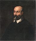
Andrea Palladio  (1508–1580)  wikidata:Q177692 s:it:Autore:Andrea Palladio q:it:Andrea Palladio
 
Andrea Palladio
Alternative names
Birth name: Andrea di Pietro della Gondola; A. Palladio; André Palladio; Andrea di Pietro; Andrea di Pietro della Gondola Palladio; Palladio
Description Italian architect and art theorist
Date of birth/death between 8 November 1508 and 30 November 1508
date QS:P,+1508-11-00T00:00:00Z/10,P1319,+1508-11-08T00:00:00Z/11,P1326,+1508-11-30T00:00:00Z/11
 Edit this at Wikidata
circa  Edit this at Wikidata
Location of birth/death Padua Edit this at Wikidata Maser Edit this at Wikidata
Work period 1537 Edit this at Wikidata–1580 Edit this at Wikidata
Work location
Authority file
creator QS:P170,Q177692
institution QS:P195,Q18810139

العربية | asturianu | беларуская | беларуская (тарашкевіца)‎ | বাংলা | català | čeština | dansk | Deutsch | English | español | euskara | فارسی | français | avañe'ẽ | עברית | हिन्दी | hrvatski | magyar | bahasa Indonesia | italiano | 日本語 | 한국어 | latviešu | македонски | മലയാളം | مازِرونی | Nederlands | polski | português | português do Brasil | română | русский | sicilianu | slovenčina | slovenščina | Türkçe | українська | Tiếng Việt | 中文 | 中文(中国大陆)‎ | 中文(简体)‎ | 中文(繁體)‎ | 中文(台灣)‎ | +/−

Date Taken on 3 June 2016
Source Own work
Author Didier Descouens
Permission
(Reusing this file)
This file is copyrighted and has been released under a license which is incompatible with Facebook's licensing terms. It is not permitted to upload this file at Facebook.
I, the copyright holder of this work, hereby publish it under the following license:
w:en:Creative Commons
attribution share alike
This file is licensed under the Creative Commons Attribution-Share Alike 4.0 International license.
You are free:
  • to share – to copy, distribute and transmit the work
  • to remix – to adapt the work
Under the following conditions:
  • attribution – You must give appropriate credit, provide a link to the license, and indicate if changes were made. You may do so in any reasonable manner, but not in any way that suggests the licensor endorses you or your use.
  • share alike – If you remix, transform, or build upon the material, you must distribute your contributions under the same or compatible license as the original.
Other versions
Object location45° 32′ 56.83″ N, 11° 32′ 57.76″ E Kartographer map based on OpenStreetMap.View this and other nearby images on: OpenStreetMapinfo

Captions

Add a one-line explanation of what this file represents

Items portrayed in this file

depicts

3 June 2016

45°32'56.832"N, 11°32'57.757"E

0.004 second

31 millimetre

image/jpeg

File history

Click on a date/time to view the file as it appeared at that time.

Date/TimeThumbnailDimensionsUserComment
current06:17, 26 August 2017Thumbnail for version as of 06:17, 26 August 20177,107 × 4,674 (20.66 MB)Archaeodontosaurus{{Information |Description ={{en|1=c}} |Source ={{own}} |Author =Archaeodontosaurus |Date = |Permission = |other_versions = }}

Global file usage

Metadata