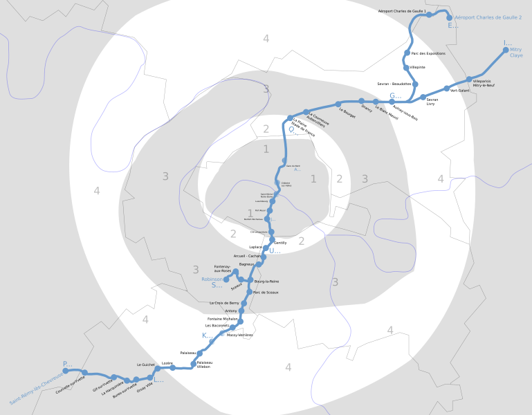
File:RER B.svg
Appearance

Size of this PNG preview of this SVG file: 769 × 600 pixels. Other resolutions: 308 × 240 pixels | 616 × 480 pixels | 985 × 768 pixels | 1,280 × 998 pixels | 2,560 × 1,996 pixels | 1,144 × 892 pixels.
Original file (SVG file, nominally 1,144 × 892 pixels, file size: 201 KB)
File history
Click on a date/time to view the file as it appeared at that time.
| Date/Time | Thumbnail | Dimensions | User | Comment | |
|---|---|---|---|---|---|
| current | 13:41, 5 August 2011 |  | 1,144 × 892 (201 KB) | Gonioul | resync with Paris_RER.svg |
| 02:14, 7 June 2011 |  | 2,411 × 2,312 (300 KB) | Gonioul | lighter zones | |
| 03:20, 25 December 2008 |  | 2,411 × 2,312 (296 KB) | Gonioul | resize test | |
| 22:01, 19 June 2006 |  | 603 × 578 (296 KB) | Pabix | This is a plan of Île de France's RER line B. Ceci est un plan de la ligne B de RER en Île de France. Category:Paris RER |
File usage
The following page uses this file:
Global file usage
The following other wikis use this file:
- Usage on ca.wikipedia.org
- Usage on de.wikipedia.org
- Usage on eo.wikipedia.org
- Usage on es.wikipedia.org
- Usage on fr.wikipedia.org
- Usage on id.wikipedia.org
- Usage on ja.wikipedia.org
- Usage on nl.wikipedia.org
- Usage on pl.wikipedia.org
- Usage on ru.wikipedia.org
- Usage on th.wikipedia.org
- Usage on vi.wikipedia.org
- Usage on www.wikidata.org
- Usage on zh.wikipedia.org


