Jump to content

File:Sault Ste Marie (ASTER).jpg

Page contents not supported in other languages.
This is a file from the Wikimedia Commons
From Wikipedia, the free encyclopedia

Original file (2,356 × 2,239 pixels, file size: 918 KB, MIME type: image/jpeg)

Summary

Description
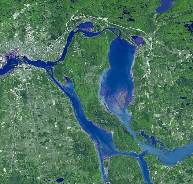
English: Sault Ste. Marie is the name of two cities on Saint Mary's River, separating Canada and the State of Michigan in the United States. Founded as a fur trading settlement in 1668, the town was split into two in 1797 when the Upper Peninsula was transferred to the U.S. The Saint Mary's River joins Lake Superior to Lake Huron. The two cities are joined by the International Bridge; the nearby Soo Locks bypass the River's rapids, and carries more tonnage than any other canal in the world. The image was acquired June 10, 2007, covers an area of 35.3 x 33.6 km, and is located at 46.4 degrees north latitude, 84.3 degrees west longitude.
Date Taken on 10 June 2007
Source

Sault Ste. Marie (direct link)

This image or video was catalogued by Jet Propulsion Laboratory of the United States National Aeronautics and Space Administration (NASA) under Photo ID: Saultste.

This tag does not indicate the copyright status of the attached work. A normal copyright tag is still required. See Commons:Licensing.
Other languages:
Author NASA/METI/AIST/Japan Space Systems, and U.S./Japan ASTER Science Team
Object location46° 24′ 00″ N, 84° 18′ 00″ W Kartographer map based on OpenStreetMap.View this and other nearby images on: OpenStreetMapinfo
This media is a product of the
Terra mission
Credit and attribution belongs to the Advanced Spaceborne Thermal Emission and Reflection Radiometer (ASTER) team, NASA/METI/AIST/Japan Space Systems

Licensing

Public domain This file is in the public domain in the United States because it was solely created by NASA. NASA copyright policy states that "NASA material is not protected by copyright unless noted". (See Template:PD-USGov, NASA copyright policy page or JPL Image Use Policy.)
Warnings:

Captions

Sault Ste. Marie is the name of two cities on Saint Mary's River, separating Canada and the State of Michigan in the United States.

Items portrayed in this file

depicts

image/jpeg

2,239 pixel

2,356 pixel

940,030 byte

4575e3c36046d3bb6ca9aaf2952a8728f4c8749c

10 June 2007

22 October 2009

28y7frm3f3kwvruxc1r4swv5qo5jah1qmumjumzx8o8u0xv9af

File history

Click on a date/time to view the file as it appeared at that time.

Date/TimeThumbnailDimensionsUserComment
current12:08, 25 June 2023Thumbnail for version as of 12:08, 25 June 20232,356 × 2,239 (918 KB)OptimusPrimeBot#Spacemedia - Upload of https://asterweb.jpl.nasa.gov/gallery/images/ssm2.jpg via Commons:Spacemedia

The following page uses this file:

Global file usage

The following other wikis use this file: