File:Scotsgap Railway Station.jpg
Page contents not supported in other languages.
Tools
Actions
General
In other projects
Appearance
Scotsgap_Railway_Station.jpg (640 × 480 pixels, file size: 96 KB, MIME type: image/jpeg)
| This is a file from the Wikimedia Commons. Information from its description page there is shown below. Commons is a freely licensed media file repository. You can help. |
Summary
| DescriptionScotsgap Railway Station.jpg |
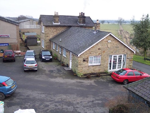
English: Former station building at Scotsgap on the 'Wannie Line', Northumberland The Wansbeck Railway, linking Reedsmouth and Morpeth, 25 miles to the east, was sponsored by the North British Railway. Scotsgap to Morpeth opened in 1862 and the following year the company was absorbed by the NBR, who saw the possibility of having a route from Edinburgh to Newcastle via Riccarton Junction, Reedsmouth and Morpeth then over the Blyth & Tyne Railway. The North Eastern Railway also saw this possibility and prevented it by absorbing the BTR in 1874. Reesdmouth to Scotsgap opened in 1865 and this was followed in 1870 by the Northumberland Central's branch from Scotsgap - Rothbury. Its subsequent absorption by the NBR two years later led to the Morpeth - Rothbury line becoming the major route. The Wannie line was the name given to the fourteen mile section between Reedsmouth and Scotsgap which operated as a feeder service, although there were never more than three passenger trains daily in each direction. Passenger services were withdrawn in 1952 and the line closed to all traffic in 1966. |
| Date | |
| Source | From geograph.org.uk |
| Author | Ralph Rawlinson |
| Permission (Reusing this file) |
Creative Commons Attribution Share-alike license 2.0 |
| Attribution (required by the license) InfoField | Ralph Rawlinson / Former station building at Scotsgap on the 'Wannie Line', Northumberland / |
InfoField | Ralph Rawlinson / Former station building at Scotsgap on the 'Wannie Line', Northumberland |
| Camera location | 55° 10′ 18.8″ N, 1° 56′ 25.12″ W | View this and other nearby images on: OpenStreetMap |
|---|
Licensing

|
This image was taken from the Geograph project collection. See this photograph's page on the Geograph website for the photographer's contact details. The copyright on this image is owned by Ralph Rawlinson and is licensed for reuse under the Creative Commons Attribution-ShareAlike 2.0 license.
|
This file is licensed under the Creative Commons Attribution-Share Alike 2.0 Generic license.
Attribution: Ralph Rawlinson
- You are free:
- to share – to copy, distribute and transmit the work
- to remix – to adapt the work
- Under the following conditions:
- attribution – You must give appropriate credit, provide a link to the license, and indicate if changes were made. You may do so in any reasonable manner, but not in any way that suggests the licensor endorses you or your use.
- share alike – If you remix, transform, or build upon the material, you must distribute your contributions under the same or compatible license as the original.
Captions
Former station building at Scotsgap on the 'Wannie Line', Northumberland
Items portrayed in this file
depicts
some value
55°10'18.80"N, 1°56'25.12"W
3 February 2006
0.008 second
2.8
8 millimetre
image/jpeg
55°10'19"N, 1°56'24"W
File history
Click on a date/time to view the file as it appeared at that time.
| Date/Time | Thumbnail | Dimensions | User | Comment | |
|---|---|---|---|---|---|
| current | 15:19, 3 October 2009 |  | 640 × 480 (96 KB) | Lamberhurst | {{geograph|126012|Ralph Rawlinson}} {{w|Scotsgap railway station}} Scotsgap Railway Station, Northumberland Category:Disused railway stations in England <!--{{ImageUpload|basic}}--> |
File usage
The following page uses this file:
Global file usage
The following other wikis use this file:
- Usage on www.wikidata.org
Metadata
This file contains additional information, probably added from the digital camera or scanner used to create or digitize it.
If the file has been modified from its original state, some details may not fully reflect the modified file.
| Camera manufacturer | EASTMAN KODAK COMPANY |
|---|---|
| Camera model | KODAK DX4530 ZOOM DIGITAL CAMERA |
| Exposure time | 1/125 sec (0.008) |
| F-number | f/2.8 |
| Date and time of data generation | 15:56, 3 February 2006 |
| Lens focal length | 8 mm |
| Orientation | Normal |
| Horizontal resolution | 230 dpi |
| Vertical resolution | 230 dpi |
| Y and C positioning | Centered |
| Custom image processing | Normal process |
| Exposure mode | Auto exposure |
| White balance | Auto white balance |
| Digital zoom ratio | 0 |
| Focal length in 35 mm film | 38 mm |
| Scene capture type | Standard |
| Contrast | Normal |
| Saturation | Normal |
| Sharpness | Normal |
| Subject distance range | Unknown |
| Exposure Program | Normal program |
| Exif version | 2.2 |
| Date and time of digitizing | 15:56, 3 February 2006 |
| Shutter speed | 7 |
| APEX aperture | 3 |
| Exposure bias | 0 |
| Maximum land aperture | 3 APEX (f/2.83) |
| Metering mode | Pattern |
| Light source | Unknown |
| Flash | Flash did not fire, compulsory flash suppression |
| Color space | sRGB |
| Exposure index | 120 |
| Sensing method | One-chip color area sensor |
Retrieved from "https://en.wikipedia.org/wiki/File:Scotsgap_Railway_Station.jpg"

