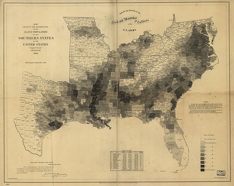
File:SlavePopulationUS1860.jpg
Appearance

Size of this preview: 752 × 600 pixels. Other resolutions: 301 × 240 pixels | 602 × 480 pixels | 963 × 768 pixels | 1,280 × 1,021 pixels | 2,560 × 2,043 pixels | 10,503 × 8,380 pixels.
Original file (10,503 × 8,380 pixels, file size: 15.5 MB, MIME type: image/jpeg)
File history
Click on a date/time to view the file as it appeared at that time.
| Date/Time | Thumbnail | Dimensions | User | Comment | |
|---|---|---|---|---|---|
| current | 22:22, 30 March 2016 |  | 10,503 × 8,380 (15.5 MB) | Scewing | Higher resolution from https://lccn.loc.gov/99447026 |
| 19:11, 11 December 2010 |  | 3,673 × 3,011 (13.36 MB) | Fred Bauder | {{Information |Description={{en|1=A map issued by the US Coast Guard showing the percentage of slaves in the population in each county in the slave-holding states of the United States in 1860, see http://opinionator.blogs.nytimes.com/2010/12/09/visualizin |
File usage
The following 6 pages use this file:
Global file usage
The following other wikis use this file:
- Usage on ar.wikipedia.org
- Usage on hy.wikipedia.org
- Usage on id.wikipedia.org
- Usage on incubator.wikimedia.org
- Usage on it.wikipedia.org
- Usage on ro.wikipedia.org
- Usage on ru.wikipedia.org
- Usage on sh.wikipedia.org
- Usage on simple.wikipedia.org
- Usage on uk.wikipedia.org
- Usage on zh.wikipedia.org


