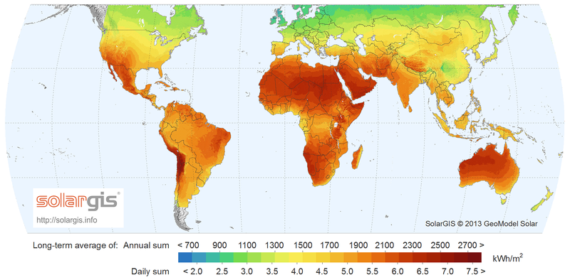
File:SolarGIS-Solar-map-World-map-en.png
Appearance

Size of this preview: 800 × 394 pixels. Other resolutions: 320 × 158 pixels | 640 × 315 pixels | 1,500 × 739 pixels.
Original file (1,500 × 739 pixels, file size: 705 KB, MIME type: image/png)
File history
Click on a date/time to view the file as it appeared at that time.
| Date/Time | Thumbnail | Dimensions | User | Comment | |
|---|---|---|---|---|---|
| current | 15:04, 18 June 2014 |  | 1,500 × 739 (705 KB) | Rfassbind | Version without heading ("World Map of Global horizontal Irradiation) |
| 14:07, 18 June 2014 |  | 1,500 × 806 (725 KB) | Rfassbind | =={{int:filedesc}}== {{Information |description={{en|1=Solar Radiation Map: Global Horizontal Irradiation Map of Switzerland, SolarGIS 2011}} |date=2011-06-12 |source=[http://solargis.info/doc/_pics/freemaps/1000px/ghi/SolarGIS-Solar-map-Switzerland-en... |
File usage
The following 2 pages use this file:
Global file usage
The following other wikis use this file:
- Usage on ar.wikipedia.org
- Usage on ca.wikipedia.org
- Usage on cs.wikipedia.org
- Usage on es.wikipedia.org
- Usage on eu.wikipedia.org
- Usage on fa.wikipedia.org
- Usage on fr.wikipedia.org
- Usage on hr.wikipedia.org
- Usage on ko.wikipedia.org
- Usage on ku.wikipedia.org
- Usage on la.wikipedia.org
- Usage on pt.wikipedia.org
- Usage on sv.wikipedia.org
- Usage on uk.wikipedia.org
- Usage on uz.wikipedia.org
- Usage on www.wikidata.org
