Jump to content

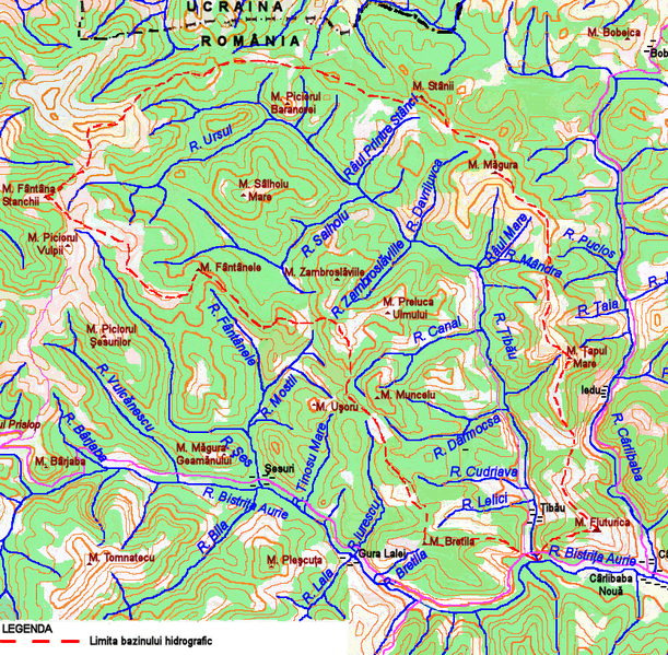
File:Tibau.png

Page contents not supported in other languages.
This is a file from the Wikimedia Commons
From Wikipedia, the free encyclopedia

Original file (833 × 817 pixels, file size: 831 KB, MIME type: image/png)

Summary

Description
English: Map of the Ţibău River Basin
Date
Source

E-mail

A Monarchia III katonai felmerese 1900 Harta 43-48
Военно-топографичекое управление генералного штаба СССР Hărţile L 35-15, L 35-3
Directia Topografica a Armatei Hărţile L35-II L35-015, L35-015-A, L35-15-Aa, L35-Ac, L35-3, L35-3-C, L35-3-Cc
Harta Turistica Obcinele Bucovinene
Harta Turistică Munţii Rodnei Est
Harta Turistică Munţii Suhard
Planul de Amenajare al bazinului hidrografic Siret (şef proiect ing. Andrei Filotti) - Bucureşti, 1962
Planul de Amenajare a Apelor din R.P.R. (şef proiect ing. Andrei Filotti) - Bucureşti, 1964
Satelite images from Wikimapia
Author Afil
Permission
(Reusing this file)
VRT Wikimedia

This work is free and may be used by anyone for any purpose. If you wish to use this content, you do not need to request permission as long as you follow any licensing requirements mentioned on this page.

The Wikimedia Foundation has received an e-mail confirming that the copyright holder has approved publication under the terms mentioned on this page. This correspondence has been reviewed by a Volunteer Response Team (VRT) member and stored in our permission archive. The correspondence is available to trusted volunteers as ticket #2010062610003383.

If you have questions about the archived correspondence, please use the VRT noticeboard. Ticket link: https://ticket.wikimedia.org/otrs/index.pl?Action=AgentTicketZoom&TicketNumber=2010062610003383
Find other files from the same ticket: SDC query (SPARQL)

Licensing

I, the copyright holder of this work, hereby publish it under the following license:
GNU head Permission is granted to copy, distribute and/or modify this document under the terms of the GNU Free Documentation License, Version 1.2 or any later version published by the Free Software Foundation; with no Invariant Sections, no Front-Cover Texts, and no Back-Cover Texts. A copy of the license is included in the section entitled GNU Free Documentation License.

Captions

Add a one-line explanation of what this file represents

Items portrayed in this file

depicts

1 October 2009

File history

Click on a date/time to view the file as it appeared at that time.

Date/TimeThumbnailDimensionsUserComment
current04:04, 26 June 2010Thumbnail for version as of 04:04, 26 June 2010833 × 817 (831 KB)Afil{{Information |Description={{en|1=Map of the Ţibău River Basin}} |Source= :A Monarchia III katonai felmerese 1900 Harta 43-48 :A Monarchia III katonai felmerese 1900 Harta 43-48 :Военно-топографичекое управление генер�
20:30, 1 October 2009Thumbnail for version as of 20:30, 1 October 2009833 × 817 (831 KB)Afil{{Information |Description={{en|1=Map of the Ţibău river basin}} |Source={{own}} |Author=Afil |Date=2009-10-1 |Permission=This image is hereby released into the public domain by its creator, Afil. This applies worldwide. |other_versions= }

The following 2 pages use this file:

Global file usage