File:Tracked Hovercraft service vehicles.jpg

Original file (1,920 × 1,260 pixels, file size: 1.24 MB, MIME type: image/jpeg)
| This is a file from the Wikimedia Commons. Information from its description page there is shown below. Commons is a freely licensed media file repository. You can help. |
Summary
| DescriptionTracked Hovercraft service vehicles.jpg |
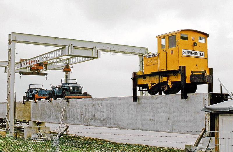
English: A locomotive curiosity is this ex-BR 3-ft gauge 'ED10', a Ruston and Hornsby-built class '48DS' 4-wheel diesel mechanical (works No.411322 of 1958) employed as a 'guided prime mover' maintenance vehicle at Tracked Hovercraft Ltd. Earith, along with two Rolls Royce-engine Austin Champ jeeps, on 17th September 1972.
Tracked Hovercraft was an experimental high speed train development company in the United Kingdom during the 1960s. It combined two British inventions, the hovercraft and linear induction motor, in an effort to produce a train system that would provide a potential 250mph inter-city service with lowered capital costs compared to other high-speed solutions. Substantially similar to the French Aérotrain, Tracked Hovercraft suffered a similar fate when it was cancelled as part of wide budget cuts in 1973. As for the Ruston, in BR departmental service 'ED10' was utilised to push narrow gauge bolsters, loaded with new sleepers, around the Beeston Sleeper Works and into the creosote pressure impregnation chambers. It arrived new at Beeston in 1958 and survived until the depot closed in February 1965. It then went to Thos. Ward who resold it on to Cleveland Bridge & Engineering Co. for use during their contract for Tinsley Viaduct on the M1 near Sheffield. ED10 subsequently went to Messrs Shephard, Hill, another firm of contractors, for use on the construction of the 3-mile length 'hover train' track. where it was photographed. After completion of this contract it was acquired for preservation and is now used conventionally at the Irchester Narrow Gauge Railway Trust in Northamptonshire, converted to 1-metre gauge and named 'Edward Charles Hampton'. |
| Date | |
| Source | Tracked Hovercraft Ruston |
| Author | Gordon Edgar from Ripon, North Yorkshire, England |
| Camera location | 52° 21′ 29.14″ N, 0° 02′ 36.96″ E | View this and other nearby images on: OpenStreetMap |
|---|
Licensing
- You are free:
- to share – to copy, distribute and transmit the work
- to remix – to adapt the work
- Under the following conditions:
- attribution – You must give appropriate credit, provide a link to the license, and indicate if changes were made. You may do so in any reasonable manner, but not in any way that suggests the licensor endorses you or your use.
- share alike – If you remix, transform, or build upon the material, you must distribute your contributions under the same or compatible license as the original.
| This image was originally posted to Flickr by Kingmoor Klickr at https://flickr.com/photos/63255278@N08/6692327847. It was reviewed on 4 April 2022 by FlickreviewR 2 and was confirmed to be licensed under the terms of the cc-by-sa-2.0. |
4 April 2022
Captions
Items portrayed in this file
depicts
some value
17 September 1972
52°21'29.138"N, 0°2'36.964"E
image/jpeg
File history
Click on a date/time to view the file as it appeared at that time.
| Date/Time | Thumbnail | Dimensions | User | Comment | |
|---|---|---|---|---|---|
| current | 18:48, 4 April 2022 |  | 1,920 × 1,260 (1.24 MB) | Maury Markowitz | Uploaded a work by Gordon Edgar from https://www.flickr.com/photos/12a_kingmoor_klickr/6692327847 with UploadWizard |
File usage
The following 2 pages use this file:
Metadata
This file contains additional information, probably added from the digital camera or scanner used to create or digitize it.
If the file has been modified from its original state, some details may not fully reflect the modified file.
| Author | Gordon Edgar |
|---|---|
| Image title |
|
| Copyright holder |
|
| Short title |
|
| Date and time of data generation | 16:40, 6 December 2018 |
| Width | 3,089 px |
| Height | 2,027 px |
| Bits per component |
|
| Compression scheme | Uncompressed |
| Pixel composition | RGB |
| Orientation | Normal |
| Number of components | 3 |
| Horizontal resolution | 72 dpi |
| Vertical resolution | 72 dpi |
| Data arrangement | chunky format |
| Software used | Adobe Photoshop Elements 16.0 (Windows) |
| File change date and time | 15:41, 16 January 2022 |
| Color space | sRGB |
| Unique ID of original document | adobe:docid:photoshop:6f4a9af6-d80b-11de-abf3-ad9d21fc8557 |
| Date and time of digitizing | 22:17, 22 November 2017 |
| Date metadata was last modified | 15:41, 16 January 2022 |
| Rating (out of 5) | 0 |
| Writer | Gordon Edgar |
| Copyright status | Copyright status not set |
| Keywords | Gordon Edgar |
| IIM version | 4,507 |
