Jump to content

File:US minimum wage map.svg

Page contents not supported in other languages.
This is a file from the Wikimedia Commons
From Wikipedia, the free encyclopedia

Original file (SVG file, nominally 959 × 593 pixels, file size: 102 KB)

This file has been superseded by Minimum wage by state and territory vs federal.svg. It is recommended to use the other file. Please note that deleting superseded images requires consent.
new file

Summary

Description

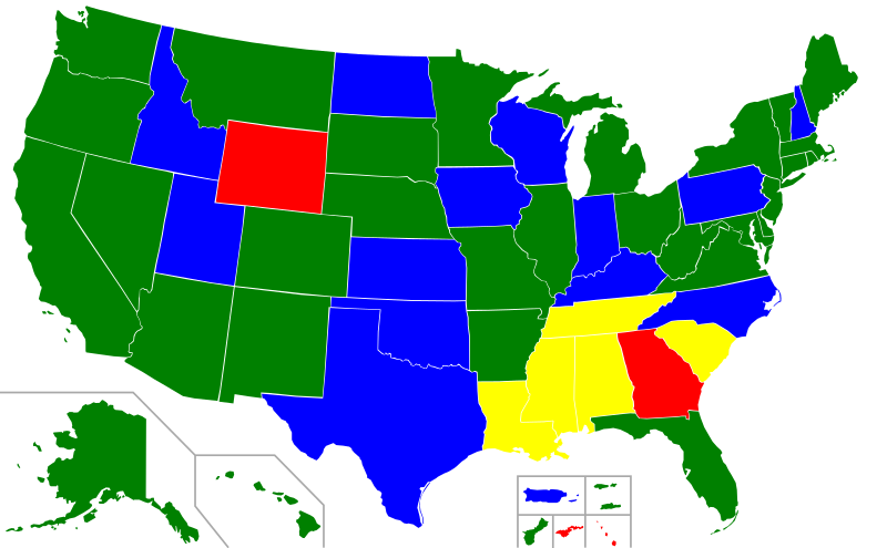
US minimum wage map. Minimum wage by U.S. state, Washington, D.C., and U.S. territory. The federal minimum wage of $7.25 per hour applies to states with no set minimum wage, and to most workers in states with lower minimum wages. Specifically, those working for employers subject to the Fair Labor Standards Act. Special minimum wages apply to some workers in American Samoa and the Northern Mariana Islands.

 
States and territories with minimum wage rates higher than the Federal rate.
 
States and territories with minimum wage rates the same as the Federal rate.
 
States with lower minimum wage rates - Federal rate applies.
 
States with no minimum wage law - Federal rate applies.
Date 22 August 2009 - Date of original file on the Commons. See file history below for date of latest upload.
Source See US map: Minimum Wage Laws in the States - Wage and Hour Division (WHD). It is from the U.S. Department of Labor. Scroll over states on that map to see exact minimum wages by state. See table of minimum wages: Consolidated Minimum Wage Table. U.S. Department of Labor.
Author
Other versions File:US minimum wage map.png
SVG development
InfoField
 
The SVG code is valid.
 
This map was created with Inkscape.


This file may be updated to reflect new information. If you wish to use a specific version of the file without it being overwritten, please upload the required version as a separate file.

Licensing

w:en:Creative Commons
attribution share alike
This file is licensed under the Creative Commons Attribution-Share Alike 3.0 Unported license.
You are free:
  • to share – to copy, distribute and transmit the work
  • to remix – to adapt the work
Under the following conditions:
  • attribution – You must give appropriate credit, provide a link to the license, and indicate if changes were made. You may do so in any reasonable manner, but not in any way that suggests the licensor endorses you or your use.
  • share alike – If you remix, transform, or build upon the material, you must distribute your contributions under the same or compatible license as the original.

Original upload log

This image is a derivative work of the following images:

  • File:Blank_USA,_w_territories.svg licensed with Cc-by-sa-3.0-migrated, GFDL
    • 2009-01-30T01:59:59Z Hoshie 959x593 (98189 Bytes) Reverted to version as of 23:58, 14 January 2009 - rv myself; DC can be seen clearly.
    • 2009-01-18T23:34:42Z Hoshie 959x593 (102341 Bytes) Put DC in an inset; fixed Tutuila (American Samoa)
    • 2009-01-14T23:58:05Z Lokal Profil 959x593 (98189 Bytes) Code cleanup and removed stroke from Guam and American Samoa
    • 2009-01-13T05:19:51Z Hoshie 959x593 (101361 Bytes) re did Guam and added American Samoa
    • 2007-12-02T16:08:45Z Lokal Profil 959x593 (88960 Bytes) {{Information |Description=A blank map of the United States including Puerto Rico, Guam, the United States Virgin Islands, and the Northern Mariana Islands. |Source=This version was made by [[:User:Lokal_Profil|Lokal_Profil]]

Uploaded with derivativeFX

Any autoconfirmed user can overwrite this file from the same source. Please ensure that overwrites comply with the guideline.

Captions

Add a one-line explanation of what this file represents

Items portrayed in this file

depicts

22 August 2009

image/svg+xml

File history

Click on a date/time to view the file as it appeared at that time.

(newest | oldest) View (newer 10 | ) (10 | 20 | 50 | 100 | 250 | 500)
Date/TimeThumbnailDimensionsUserComment
current03:53, 20 November 2021Thumbnail for version as of 03:53, 20 November 2021959 × 593 (102 KB)ErgzayCorrect status of Wyoming and Georgia - this map needs to match US government map
14:20, 3 May 2021Thumbnail for version as of 14:20, 3 May 2021959 × 593 (102 KB)CarhlesVirginia is now $9.50
18:25, 19 April 2019Thumbnail for version as of 18:25, 19 April 2019959 × 593 (102 KB)TimeshifterReverted to version as of 16:50, 19 April 2019 (UTC). See talk. Those are small carve outs not covered by federal minimum wage. Table confirms this.
18:01, 19 April 2019Thumbnail for version as of 18:01, 19 April 2019959 × 593 (102 KB)Terrorist96I'll wait until you actually click on GA and WY in the map here https://www.dol.gov/whd/minwage/america.htm
16:50, 19 April 2019Thumbnail for version as of 16:50, 19 April 2019959 × 593 (102 KB)TimeshifterReverted to version as of 18:54, 13 April 2019 (UTC). Only CNMI has a lower minimum wage than the federal MW. See: https://www.dol.gov/whd/minwage/mw-consolidated.htm
14:55, 17 April 2019Thumbnail for version as of 14:55, 17 April 2019959 × 593 (102 KB)Terrorist96While the federal minimum applies, GA and WY law say the minimum wage is $5.15 according to your own source.
18:54, 13 April 2019Thumbnail for version as of 18:54, 13 April 2019959 × 593 (102 KB)DaviddwdUpdated data from March 29, 2019 from the [https://www.dol.gov/whd/minwage/america.htm United States Department of Labor]; fixed my color mistake.
18:49, 13 April 2019Thumbnail for version as of 18:49, 13 April 2019959 × 593 (102 KB)DaviddwdUpdated based on March 29, 2019 data from [https://www.dol.gov/whd/minwage/america.htm#stateDetails the United States Department of Labor]
21:31, 28 September 2015Thumbnail for version as of 21:31, 28 September 2015959 × 593 (102 KB)Delphi234correct Florida
00:14, 6 January 2015Thumbnail for version as of 00:14, 6 January 2015959 × 593 (102 KB)Delphi234January 1, 2015
(newest | oldest) View (newer 10 | ) (10 | 20 | 50 | 100 | 250 | 500)
No pages on the English Wikipedia use this file (pages on other projects are not listed).

Global file usage

The following other wikis use this file:

Metadata