Jump to content

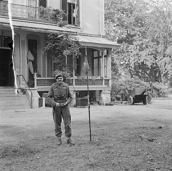
File:Urquhart outside his headquarters.jpg

Page contents not supported in other languages.
This is a file from the Wikimedia Commons
From Wikipedia, the free encyclopedia

Original file (800 × 798 pixels, file size: 131 KB, MIME type: image/jpeg)

Description
English: IWM caption : OPERATION 'MARKET GARDEN' (THE BATTLE FOR ARNHEM) : 17 - 25 SEPTEMBER 1944. Major-General Roy Urquhart DSO and Bar (leader of the 1st British Airborne Division during the Arnhem Operation) plants the Airborne flag outside his headquarters (Hotel Hartenstein), the last British stronghold in the Arnhem area before the evacuation
Nederlands: Generaal-Majoor Roy Urquhart bij zijn hoofdkwartier in Hotel Hartenstein in Oosterbeek, het tegenwoordige Airborne museum, tijdens operatie Market-Garden. (Slag om Arnhem) 17 - 25 september 1944.
Date Taken on 22 September 1944
Source
Image of the exterior main entrance to the Imperial War Museum in London. This photograph BU 1136 comes from the collections of the Imperial War Museums
(collection no. 4700-30)
Flag of the United Kingdom.
Author Smith, D M (Sgt), Army Film and Photographic Unit
Permission
(Reusing this file)
Public domain
This work created by the United Kingdom Government is in the public domain.

This is because it is one of the following:

  1. It is a photograph taken prior to 1 June 1957; or
  2. It was published prior to 1974; or
  3. It is an artistic work other than a photograph or engraving (e.g. a painting) which was created prior to 1974.

HMSO has declared that the expiry of Crown Copyrights applies worldwide (ref: HMSO Email Reply)
More information.

See also Copyright and Crown copyright artistic works.

Deutsch  English  Español  français  italiano  Nederlands  polski  português  sicilianu  slovenščina  suomi  Türkçe  македонски  русский  українська  മലയാളം  한국어  日本語  简体中文  繁體中文  العربية  +/−

Camera location51° 59′ 15.05″ N, 5° 49′ 57.99″ E Kartographer map based on OpenStreetMap.View this and other nearby images on: OpenStreetMapinfo

Captions

Add a one-line explanation of what this file represents

Items portrayed in this file

depicts

22 September 1944

51°59'15.050"N, 5°49'57.990"E

File history

Click on a date/time to view the file as it appeared at that time.

Date/TimeThumbnailDimensionsUserComment
current05:30, 20 November 2011Thumbnail for version as of 05:30, 20 November 2011800 × 798 (131 KB)Wolcotthigher resolution
13:16, 9 June 2005Thumbnail for version as of 13:16, 9 June 2005688 × 653 (111 KB)W.wolny

The following 3 pages use this file:

Global file usage

The following other wikis use this file: