Motuoapa
Motuoapa | |
|---|---|
Rural settlement | |
 | |
| Coordinates: 38°56′02″S 175°52′23″E / 38.934°S 175.873°E | |
| Country | New Zealand |
| Region | Waikato region |
| District | Taupō District |
| Ward | Turangi-Tongariro Ward |
| Community | Turangi-Tongariro Community |
| Electorates | |
| Government | |
| • Territorial Authority | Taupō District Council |
| • Regional council | Waikato Regional Council |
| Area | |
• Total | 3.34 km2 (1.29 sq mi) |
| Population (June 2024)[2] | |
• Total | 460 |
| • Density | 140/km2 (360/sq mi) |
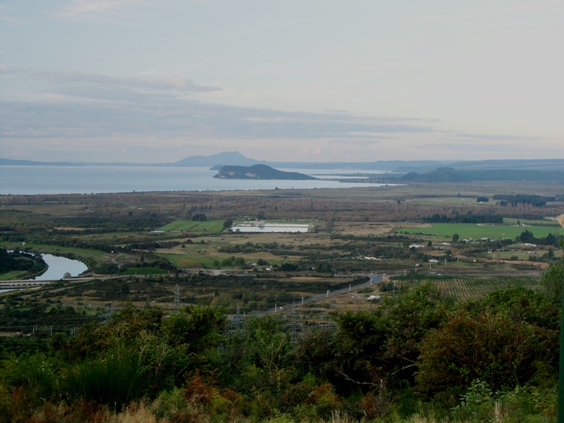
Motuoapa is a rural settlement northeast of Tūrangi, on the southeast side of New Zealand's Lake Taupō.[3] State Highway 1 runs through it. Motuoapa Peninsula, a volcano, rises to the northwest, with a trig point at 497 metres, and Motuoapa Bay is directly to the north.[4]
A youth hostel opened at Motuoapa in 1955[5] and a marina was built in 1961.[6]
Demographics
[edit]Statistics New Zealand describes Motuoapa as a rural settlement, which covers 3.34 km2 (1.29 sq mi)[1] and had an estimated population of 460 as of June 2024,[2] with a population density of 138 people per km2. The settlement is part of the larger Lake Taupo Bays statistical area.[7]
| Year | Pop. | ±% p.a. |
|---|---|---|
| 2006 | 228 | — |
| 2013 | 237 | +0.55% |
| 2018 | 360 | +8.72% |
| Source: [8] | ||
Motuoapa had a population of 360 at the 2018 New Zealand census, an increase of 123 people (51.9%) since the 2013 census, and an increase of 132 people (57.9%) since the 2006 census. There were 159 households, comprising 171 males and 189 females, giving a sex ratio of 0.9 males per female, with 39 people (10.8%) aged under 15 years, 21 (5.8%) aged 15 to 29, 174 (48.3%) aged 30 to 64, and 129 (35.8%) aged 65 or older.
Ethnicities were 85.0% European/Pākehā, 20.8% Māori, 0.8% Pacific peoples, 3.3% Asian, and 3.3% other ethnicities. People may identify with more than one ethnicity.
Although some people chose not to answer the census's question about religious affiliation, 51.7% had no religion, 39.2% were Christian, 0.8% had Māori religious beliefs and 0.8% had other religions.
Of those at least 15 years old, 66 (20.6%) people had a bachelor's or higher degree, and 63 (19.6%) people had no formal qualifications. 48 people (15.0%) earned over $70,000 compared to 17.2% nationally. The employment status of those at least 15 was that 120 (37.4%) people were employed full-time, 54 (16.8%) were part-time, and 6 (1.9%) were unemployed.[8]
Geology
[edit]
The highest point of Motuoapa Peninsula, at its north-eastern tip is a dacite volcano that has been dated as last erupting at 34,500 ± 3,100 years ago.[9] The other volcanic formations, some of which the dacite cone is built upon, are older rhyolite with two different eruption ages of 81,300 and 77,200 years ago.[9] At the time of the rhyolite eruptions, they were initially on the lake floor of the former Lake Huka which was replaced by Lake Taupō after the Oruanui eruption of the Taupō Volcano 25,400 years ago.[9] Although the magma reservoir that fed these Motuoapa eruptions appears to be separate from the one(s) that produced the more recent much larger Taupō eruptions, the type of eruption commencing under water but not staying underwater is felt possible in the future from the Taupō Volcano.[9] A perhaps unexpected characteristic is the thickness of the pyroclastic deposits produced at Motuoapa, as these indicate that such rhyolite dome building which was assumed to be mostly effusive, can have explosive pyroclastic stages that would be very disruptive and dangerous.[9]
References
[edit]- ^ a b "ArcGIS Web Application". statsnz.maps.arcgis.com. Retrieved 13 November 2022.
- ^ a b "Aotearoa Data Explorer". Statistics New Zealand. Retrieved 26 October 2024.
- ^ "Place name detail: Motuoapa". New Zealand Gazetteer. New Zealand Geographic Board. Retrieved 13 November 2022.
- ^ Harriss, Gavin (August 2022). Motuoapa, Waikato (Map). NZ Topomap.
- ^ "Youth Hostels in N.Z. Increase in Members". The Press. 12 May 1956.
- ^ "Boating Marina Built On Lake Taupo Shores". The Press. 24 October 1961.
- ^ 2018 Census place summary: Lake Taupo Bays
- ^ a b "Statistical area 1 dataset for 2018 Census". Statistics New Zealand. March 2020. 7013299 and 7013300.
- ^ a b c d e Kósik, S; Németh, K; Danišík, M; Procter, JN; Schmitt, AK; Friedrichs, B; Stewart, RB (2021). "Shallow subaqueous to emergent intra-caldera silicic volcanism of the Motuoapa Peninsula, Taupo Volcanic Zone, New Zealand–New constraints from geologic mapping, sedimentology and zircon geochronology" (PDF). Journal of Volcanology and Geothermal Research. 411 (107180). doi:10.1016/j.jvolgeores.2021.107180. Retrieved 25 November 2023.

