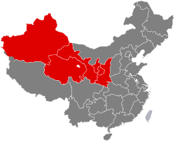
Northwestern China
This article needs additional citations for verification. (June 2022) |
Northwestern China | |
|---|---|
 | |
| Country | |
| Area | |
• Total | 3,107,900 km2 (1,200,000 sq mi) |
| Population | 103,528,786 |
| • Density | 31/km2 (80/sq mi) |
| GDP | 2022[2] |
| - Total | ¥7.040 trillion $1.047 trillion |
| - Per Capita | ¥68,000 $10,110 |
Northwestern China (西北) is a region in the People's Republic of China. It consists of five provincial administrative regions, namely Shaanxi, Gansu, Qinghai, Ningxia, and Xinjiang.
The region is characterized by a (semi-)arid continental climate. It has a diverse population including significant minorities such as Hui, Uyghurs and Tibetans.[3][4] Culturally, the region has historically been influenced by the Silk Road.[5]
Historic security considerations
[edit]Chinese dynasties from the Qin (221 BC to 207 BC) to the Qing period (1644 CE to 1911 CE) placed high priority on maintaining stability and security in the region, motivated by concerns about potential threats from the Northwest.[6]
Security concerns have continued under modern governments.[6] During the Republic of China period, the government was only able to exercise loose control in the Northwest.[6] In 1933, Pan-Islamic and Pan-Turkic separatists declared an Islamic Republic of East Turkestan based on constitutionally-enshrined Sharia law.[6] The short-lived separatist Islamic Republic was not recognized by any other countries and was suppressed after three months of existence.[6]
With Soviet Union backing, separatists declared a second short-lived East Turkestan Republic in 1944 based in Yining.[6] The Soviet Union withdrew its support in June 1946.[6] A separatist movement drawing on the legacy of the short-lived East Turkestan Republics continues today.[6]
Northwestern China during land reform movement
[edit]During China's land reform movement (which began after the defeat of the Japanese in the Second Sino-Japanese War and continued in the early years of the People's Republic of China), the Communist Party encouraged rural women in achieving a "double fanshen" - a revolutionary transformation as both a peasant and a feminist awakening as a woman.[7] The progress of Hui women in Northwestern China was promoted as by the Party as an example of such a success.[8] Through the rural movement, Hui women were said to have not just received land, but also "freedom over their own bodies."[8] Hui women embraced political participation and the rural revolution.[8] The land reform movement succeeded among Hui people because activists first won over elder generations.[8]
Administrative divisions
[edit]| GB[9] | ISO No.[10] | Province | Chinese Name | Capital | Population | Density (per km2) | Area (km2) | Abbreviation/Symbol | |
|---|---|---|---|---|---|---|---|---|---|
| Shǎn (Qín) | 61 | Shaanxi Province | 陕西省 Shǎnxī Shěng |
Xi'an | 39,530,000 | 190 | 205,600 | SN | 陕(秦) |
| Gān (Lǒng) | 62 | Gansu Province | 甘肃省 Gānsù Shěng |
Lanzhou | 25,019,831 | 55 | 454,300 | GS | 甘(陇) |
| Qīng | 63 | Qinghai Province | 青海省 Qīnghǎi Shěng |
Xining | 5,923,957 | 8.2 | 721,200 | QH | 青 |
| Níng | 64 | Ningxia Hui Autonomous Region | 宁夏回族自治区 Níngxià Huízú Zìzhìqū |
Yinchuan | 7,202,654 | 110 | 66,400 | NX | 宁 |
| Xīn | 65 | Xinjiang Uyghur Autonomous Region | 新疆维吾尔自治区 Xīnjiāng Wéiwú'ěr Zìzhìqū |
Ürümqi | 25,852,345 | 16 | 1,660,400 | XJ | 新 |
Cities with urban area over one million in population
[edit]| # | City | Urban area | District area | City proper | Prov. | Census date |
|---|---|---|---|---|---|---|
| 1 | Xi'an | 11,904,805 | 12,283,922 | 12,952,907 | SN | 2020 |
| 2 | Ürümqi | 3,575,000 | 4,054,369 | XJ | 2020 | |
| 3 | Lanzhou | 3,474,858 | 3,042,863 | 4,359,446 | GS | 2020 |
| 4 | Yinchuan | 1,901,793 | 1,901,793 | 2,859,074 | NX | 2020 |
| 5 | Xining | 1,954,795 | 1,954,795 | 2,467,965 | QH | 2020 |
| 6 | Baoji | 1,862,118 | 1,475,962 | 3,321,853 | SN | 2020 |
| 7 | Tianshui | 1,212,791 | 1,212,791 | 1,212,791 | GS | 2020 |
See also
[edit]References
[edit]- ^ "Main Data of the Seventh National Population Census". National Bureau of Statistics of China. Archived from the original on May 11, 2021.
- ^ GDP-2022 is a preliminary data "Home - Regional - Quarterly by Province" (Press release). China NBS.
- ^ Chen, Yaning (2014-03-23). Water Resources Research in Northwest China. Springer Science & Business Media. ISBN 978-94-017-8017-9.
- ^ Dillon, Michael (2013-12-16). China's Muslim Hui Community: Migration, Settlement and Sects. Routledge. ISBN 978-1-136-80940-8.
- ^ "Chinese Section of the Silk Road: Land routes in Henan Province, Shaanxi Province, Gansu Province, Qinghai Province, Ningxia Hui Autonomous Region, and Xinjiang Uygur Autonomous Region; Sea Routes in Ningbo City, Zhejiang Province and Quanzhou City, Fujian Province - from Western-Han Dynasty to Qing Dynasty". UNESCO World Heritage Centre. Retrieved 2021-08-23.
- ^ a b c d e f g h Zhao, Huasheng (2016). "Central Asia in Chinese Strategic Thinking". The new great game : China and South and Central Asia in the era of reform. Thomas Fingar. Stanford, California: Stanford University Press. p. 175. ISBN 978-0-8047-9764-1. OCLC 939553543.
- ^ DeMare, Brian James (2019). Land wars : the story of China's agrarian revolution. Stanford, California: Stanford University Press. pp. 140–141. ISBN 978-1-5036-0849-8. OCLC 1048940018.
- ^ a b c d DeMare, Brian James (2019). Land wars : the story of China's agrarian revolution. Stanford, California: Stanford University Press. p. 141. ISBN 978-1-5036-0849-8. OCLC 1048940018.
- ^ CHGIS. "Database Design". www.people.fas.harvard.edu. Retrieved 31 March 2018.
- ^ ISO 3166-2:CN (ISO 3166-2 codes for the provinces of China)
