Pobiedziska
Pobiedziska | |
|---|---|
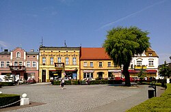
 The Pobiedziska market square | |
| Coordinates: 52°29′41″N 17°16′2″E / 52.49472°N 17.26722°E | |
| Country | |
| Voivodeship | Greater Poland |
| County | Poznań |
| Gmina | Pobiedziska |
| Area | |
• Total | 10.16 km2 (3.92 sq mi) |
| Population (2006) | |
• Total | 8,329 |
| • Density | 820/km2 (2,100/sq mi) |
| Time zone | UTC+1 (CET) |
| • Summer (DST) | UTC+2 (CEST) |
| Postal code | 62-010 |
| Vehicle registration | PZ, POZ |
| Climate | Dfb |
| Primary airport | Poznań–Ławica Airport |
| Voivodeship road | |
| Website | http://www.pobiedziska.pl/ |
Pobiedziska ([pɔbʲɛˈd͡ʑiska]) (German: Pudewitz) is a town in Poznań County, Poland, with 8,209 inhabitants as of the year 2004. It is also the seat of the administrative district (gmina) called Gmina Pobiedziska.
The town's name comes from the word pobieda meaning victory. It was named by Casimir I the Restorer in 1048 AD, possibly to commemorate his defeat of Masław, a rebellious Masovian namiestnik.[1]
History
[edit]
In 1257, Pobiedziska was granted town privileges by Duke Przemysl who was co-ruler of Posen, making the town independent from the Ostrów Lednicki castellany. In the various campaigns initiated by the Poles, in 1331, the town was destroyed by the Teutonic Knights and it took many years to recover. It was a royal town of the Kingdom of Poland, administratively located in the Gniezno County in the Kalisz Voivodeship in the Greater Poland Province.[2]
The town was often visited by Władysław Jagiełło. In 1423 he funded the construction of a Church of the Holy Spirit as well as a hospital for the poor.
After a century of anarchy in Poland, the country was partitioned between Europe's three Great Powers, Russia, Prussia and Austria. During the Second Partition of Poland, the province of Posen was annexed by the Kingdom of Prussia in 1793. After the Napoleonic wars it was re-annexed by Prussia in 1815, and from 1871 Posen province was also part of German Empire. The Treaty of Versailles awarded Posen province, including the town, to the new resurrected Poland.
Following the joint German-Soviet invasion of Poland, which started World War II in September 1939, the town was occupied by Germany until 1945. The first expulsions of 218 Poles were carried out in December 1939.[3] A local unit of the Wielkopolska Organizacja Wojskowa Polish resistance organization was founded already in 1939, and the following year it became part of the larger Wojskowa Organizacja Ziem Zachodnich organization.[4] Mieczysław Golus, commander of the local unit of the Union of Armed Struggle, was arrested by the Germans in 1942 and then sentenced to death and executed the following year.[5]
Demographics
[edit]
|
| ||||||||||||||||||||||||||||||||||||
| Source: [6][7] | |||||||||||||||||||||||||||||||||||||
Sights
[edit]Sights of Pobiedziska include:
- Rynek (Market Square) with colourful old townhouses and the Greater Poland Uprising (1918–1919) Monument, a statue of Jesus Christ and the Lech, Czech, and Rus' Fountain
- Gothic Saint Michael Archangel church
- Monument to Casimir I the Restorer
- Lakes: Biezdruchowskie, Małe, Dobre
- Medieval open-air museum
- Miniature park
- Neoclassical Holy Spirit church
- Convent of the Society of the Sacred Heart
- Former home and memorial of Michał Kozal, Polish bishop murdered by Nazi Germany in the Dachau concentration camp, Blessed of the Catholic Church.
Transport
[edit]
There are two railway stations in the town: Pobiedziska and Pobiedziska Letnisko, and the voivodeship road 194 passes through the town.
Sport
[edit]Pobiedziska is home to the football team Huragan Pobiedziska.
Notable residents
[edit]- Michał Kozal (1893–1943), Polish Roman Catholic bishop, murdered by the Germans in the Dachau concentration camp, served as a vicar in Pobiedziska in 1918–1920.
- Andrzej Pieczyński (born 1956), actor
- Antoni Palluth (1900-1944), cryptographer and engineer
- Antoni Świadek (1909-1945), priest and martyr
- Jarosław Molenda (born 1965), writer
- Wacław Strażewicz (born 1952), politician
- Willy Kaiser (1912–1986), German boxer, Olympic Gold medal 1936
References
[edit]- ^ (in Polish) Official website of Pobiedziska - History of the town and region
- ^ Atlas historyczny Polski. Wielkopolska w drugiej połowie XVI wieku. Część I. Mapy, plany (in Polish). Warszawa: Instytut Historii Polskiej Akademii Nauk. 2017. p. 1b.
- ^ Wardzyńska, Maria (2017). Wysiedlenia ludności polskiej z okupowanych ziem polskich włączonych do III Rzeszy w latach 1939-1945 (in Polish). Warszawa: IPN. p. 153. ISBN 978-83-8098-174-4.
- ^ Encyklopedia konspiracji Wielkopolskiej 1939–1945 (in Polish). Poznań: Instytut Zachodni. 1998. pp. 627, 646. ISBN 83-85003-97-5.
- ^ Encyklopedia konspiracji Wielkopolskiej 1939–1945. p. 179.
- ^ Dokumentacja Geograficzna (in Polish). Vol. 3/4. Warszawa: Instytut Geografii Polskiej Akademii Nauk. 1967. p. 38.
- ^ Stan i struktura ludności oraz ruch naturalny w przekroju terytorialnym w 2010 r. (PDF) (in Polish). Warszawa: Główny Urząd Statystyczny. 2011. p. 105. Archived from the original (PDF) on 13 November 2011.


