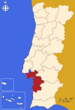
Setúbal District
Appearance
(Redirected from Setúbal district)
District of Setúbal | |
|---|---|
 | |
| Coordinates: 38°31′27.5″N 8°53′33.4″W / 38.524306°N 8.892611°W | |
| Country | Portugal |
| Region | Lisbon and Alentejo |
| Historical province | Estremadura and Baixo Alentejo |
| No. of municipalities | 13 |
| No. of parishes | 55 |
| Capital | Setúbal |
| Area | |
• Total | 5,064 km2 (1,955 sq mi) |
| Population | |
• Total | 887,928 |
| • Density | 180/km2 (450/sq mi) |
| ISO 3166 code | PT-15 |
| No. of parliamentary representatives | 19 |
The District of Setúbal (Portuguese: Distrito de Setúbal [sɨˈtuβal] ) is a district located in the south-west of Portugal. It is named for its capital, the city of Setúbal.
Geography
[edit]It is delimited by Lisbon District and Santarém District on the north, Évora District on the east, Beja District on the south and the Atlantic Ocean on the west. It has a population of 887,928 inhabitants,[1] in an area of 5,064 km2 (1,955 sq mi). The district was carved out of Lisbon District in 1926, and is the only Portuguese district created after 1835.[2]
Municipalities
[edit]It is composed of 13 municipalities, spread over two sub regions and comprising 55 parishes:[3]
List of Parliamentary Representatives
[edit]| Member | Party |
|---|---|
| Ana Catarina Mendes | PS |
| André Pinotes Batista | PS |
| Bruno Dias | PCP |
| Eurídice Pereira | PS |
| Clarisse Campos | PS |
| Cristina Rodrigues | PAN |
| Maria da Graça Reis | PS |
| Fernanda Velez | PSD |
| Fernando José | PS |
| Fernando Negrão | PSD |
| Filipe Pacheco | PS |
| Francisco Lopes | PCP |
| Joana Mortágua | BE |
| José Luís Ferreira | PEV |
| Maria Antónia de Almeida Santos | PS |
| Nuno Miguel Carvalho | PSD |
| Paula Santos | PCP |
| Sandra Cunha | BE |
| Sofia Araújo | PS |
Summary of votes and seats won 1976-2022
[edit]| Parties | % | S | % | S | % | S | % | S | % | S | % | S | % | S | % | S | % | S | % | S | % | S | % | S | % | S | % | S | % | S | % | S |
|---|---|---|---|---|---|---|---|---|---|---|---|---|---|---|---|---|---|---|---|---|---|---|---|---|---|---|---|---|---|---|---|---|
| 1976 | 1979 | 1980 | 1983 | 1985 | 1987 | 1991 | 1995 | 1999 | 2002 | 2005 | 2009 | 2011 | 2015 | 2019 | 2022 | |||||||||||||||||
| PS | 32.2 | 7 | 21.4 | 4 | 23.5 | 4 | 30.6 | 6 | 16.5 | 3 | 17.6 | 3 | 28.4 | 5 | 44.9 | 9 | 43.7 | 8 | 39.3 | 7 | 43.6 | 8 | 34.0 | 7 | 26.9 | 5 | 34.3 | 7 | 38.6 | 9 | 45.7 | 10 |
| PSD | 8.4 | 1 | In AD | 12.7 | 2 | 15.4 | 3 | 32.6 | 6 | 34.7 | 6 | 18.4 | 3 | 18.0 | 3 | 24.7 | 5 | 16.1 | 3 | 16.4 | 3 | 25.2 | 5 | In PàF | 14.4 | 3 | 16.2 | 3 | ||||
| CDS-PP | 4.4 | 5.1 | 1 | 3.8 | 1.9 | 2.7 | 7.2 | 1 | 5.6 | 1 | 6.9 | 1 | 5.1 | 1 | 9.1 | 1 | 12.1 | 2 | 3.0 | 1.1 | ||||||||||||
| PCP/APU/CDU | 44.4 | 9 | 47.0 | 9 | 44.0 | 9 | 45.8 | 8 | 38.2 | 7 | 32.7 | 7 | 24.9 | 5 | 24.8 | 4 | 24.8 | 5 | 20.5 | 4 | 20.0 | 3 | 20.1 | 4 | 19.6 | 4 | 18.8 | 4 | 15.8 | 3 | 10.1 | 2 |
| AD | 22.3 | 4 | 24.1 | 4 | ||||||||||||||||||||||||||||
| PRD | 20.4 | 4 | 8.7 | 1 | ||||||||||||||||||||||||||||
| BE | 3.5 | 4.6 | 10.3 | 2 | 14.0 | 2 | 7.1 | 1 | 13.1 | 2 | 12.1 | 2 | 5.8 | 1 | ||||||||||||||||||
| PàF | 22.6 | 5 | ||||||||||||||||||||||||||||||
| PAN | 4.4 | 1 | 2.0 | |||||||||||||||||||||||||||||
| CHEGA | 1.9 | 9.0 | 1 | |||||||||||||||||||||||||||||
| IL | 1.1 | 5.1 | 1 | |||||||||||||||||||||||||||||
| Total seats | 17 | 16 | 17 | 18 | ||||||||||||||||||||||||||||
| Source: Comissão Nacional de Eleições | ||||||||||||||||||||||||||||||||
References
[edit]- ^ "Statistics Portugal - Web Portal". www.ine.pt. Retrieved 2024-04-19.
- ^ Gwillim Law (1999). "Portugal". Administrative Subdivisions of Countries: A Comprehensive World Reference, 1900 through 1998. US: McFarland & Company. pp. 296+. ISBN 0786407298.
- ^ "Diário da República, 1.ª série" (PDF).
- ^ "Deputados".

