Akçakent District: Difference between revisions
Appearance
Content deleted Content added
moved part from Akçakent |
Wikipedia:Articles for deletion/Akçakent District closed as keep (XFDcloser) |
||
| (3 intermediate revisions by 3 users not shown) | |||
| Line 3: | Line 3: | ||
| type = district |
| type = district |
||
| name = |
| name = |
||
| image_skyline = |
| image_skyline = |
||
| image_caption = |
| image_caption = |
||
| image_shield = |
| image_shield = |
||
| image_map = Kırşehir location Akçakent.png |
| image_map = Kırşehir location Akçakent.png |
||
| Line 22: | Line 22: | ||
}} |
}} |
||
'''Akçakent District''' is a [[Districts of Turkey|district]] of the [[Kırşehir Province]] of Turkey. Its seat is the town of [[Akçakent]].<ref name=ilce>[https://www.e-icisleri.gov.tr/Anasayfa/MulkiIdariBolumleri.aspx İlçe Belediyesi], Turkey Civil Administration Departments Inventory. Retrieved 1 March 2023.</ref> Its area is 370 km<sup>2</sup>,<ref>{{cite web|url=https://www.harita.gov.tr/uploads/files-folder/il_ilce_alanlari.xlsx|title=İl ve İlçe Yüz ölçümleri|publisher=General Directorate of Mapping|access-date=1 March 2023}}</ref> and its population is 3,519 (2022).<ref>{{Cite web |title=Address-based population registration system (ADNKS) results dated 31 December 2022, Favorite Reports|url=https://biruni.tuik.gov.tr/medas/?kn=95&locale=en |access-date=13 March 2023|publisher=[[TÜİK]]|language=en|format=XLS}}</ref> |
'''Akçakent District''' is a [[Districts of Turkey|district]] of the [[Kırşehir Province]] of Turkey. Its seat is the town of [[Akçakent]].<ref name=ilce>[https://www.e-icisleri.gov.tr/Anasayfa/MulkiIdariBolumleri.aspx İlçe Belediyesi], Turkey Civil Administration Departments Inventory. Retrieved 1 March 2023.</ref> Its area is 370 km<sup>2</sup>,<ref>{{cite web|url=https://www.harita.gov.tr/uploads/files-folder/il_ilce_alanlari.xlsx|title=İl ve İlçe Yüz ölçümleri|publisher=General Directorate of Mapping|access-date=1 March 2023}}</ref> and its population is 3,519 (2022).<ref>{{Cite web |title=Address-based population registration system (ADNKS) results dated 31 December 2022, Favorite Reports|url=https://biruni.tuik.gov.tr/medas/?kn=95&locale=en |access-date=13 March 2023|publisher=[[TÜİK]]|language=en|format=XLS}}</ref> |
||
The district was formed in 1990.<ref>{{Cite web |title=İl İdaresi ve Mülki Bölümler Şube Müdürlüğü İstatistikleri - İl ve İlçe Kuruluş Tarihleri |url=https://www.icisleri.gov.tr/kurumlar/icisleri.gov.tr/IcSite/illeridaresi/İstatistiki%20Bilgiler/İl%20İdaresi%20ve%20Mülki%20Bölümler/il%20ilce%20kurulus%20tarihleri_2019.pdf |access-date=27 December 2022 |page=54 |language=tr}}</ref> |
|||
==Composition== |
==Composition== |
||
Latest revision as of 03:53, 24 April 2023
Akçakent District | |
|---|---|
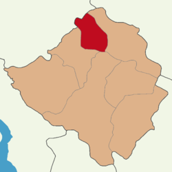
 Map showing Akçakent District in Kırşehir Province | |
| Coordinates: 39°37′N 34°05′E / 39.617°N 34.083°E | |
| Country | Turkey |
| Province | Kırşehir |
| Seat | Akçakent |
| Government | |
| • Kaymakam | Hüseyin Aydın |
Area | 370 km2 (140 sq mi) |
| Population (2022) | 3,519 |
| • Density | 9.5/km2 (25/sq mi) |
| Time zone | UTC+3 (TRT) |
| Website | www |
Akçakent District is a district of the Kırşehir Province of Turkey. Its seat is the town of Akçakent.[1] Its area is 370 km2,[2] and its population is 3,519 (2022).[3]
The district was formed in 1990.[4]
Composition
[edit]There is one municipality in Akçakent District:[1]
There are 20 villages in Akçakent District:[5]
- Avanoğlu
- Ayvalı
- Derefakılı
- Güllühüyük
- Hacıfakılı
- Hamzabey
- Hasanali
- Kilimli
- Kösefakılı
- Küçükabdiuşağı
- Mahsenli
- Ödemişli
- Ömeruşağı
- Polatlı
- Solakuşağı
- Taşoluk
- Tepefakılı
- Yaylaözü
- Yeşildere
- Yetikli
References
[edit]- ^ a b İlçe Belediyesi, Turkey Civil Administration Departments Inventory. Retrieved 1 March 2023.
- ^ "İl ve İlçe Yüz ölçümleri". General Directorate of Mapping. Retrieved 1 March 2023.
- ^ "Address-based population registration system (ADNKS) results dated 31 December 2022, Favorite Reports" (XLS). TÜİK. Retrieved 13 March 2023.
- ^ "İl İdaresi ve Mülki Bölümler Şube Müdürlüğü İstatistikleri - İl ve İlçe Kuruluş Tarihleri" (PDF) (in Turkish). p. 54. Retrieved 27 December 2022.
- ^ Köy, Turkey Civil Administration Departments Inventory. Retrieved 1 March 2023.


