Saint-Narcisse: Difference between revisions
Gordalmighty (talk | contribs) changed pushpin map to localized version |
Revision of the introduction |
||
| Line 100: | Line 100: | ||
}} |
}} |
||
'''Saint-Narcisse''' is a [[parish municipality (Quebec)|parish municipality]] in the [[ |
'''Saint-Narcisse''' is a [[parish municipality (Quebec)|parish municipality]] located in the [[regional county municipality]] (MRC) [[Les Chenaux|Chenaux]], in the administrative region of [[Mauricie]], in the [[province of Quebec]], in [[Canada]].<ref>{{cite web|url=http://www.mamrot.gouv.qc.ca/repertoire-des-municipalites/fiche/municipalite/37240/|title=Saint-Narcisse|series=municipal Directory|author= Government of Quebec|website=Ministry of Municipal Affairs, Regions and land Occupancy|date=January 11, 2011}}</ref>. Located on the North Shore of the [[St. Lawrence River]], about thirty kilometers from downtown [[Trois-Rivières]], the parish of Saint-Narcisse is the heart of the [[Mauricie]] region. |
||
With an area of 104.87 square kilometers, the city territory is divided by rows: Grande Ligne (Great line), the second highest rank Saint-Felix, Rang Sainte-Marguerite and rank Dam. The territory also includes the "lake Morin" (Popularly named "Petit lac" - Little Lake) which is located north of the Grande Ligne (Great Line). A line of mountains crosses the municipal territory along its entire length, separating the plate of Middle Mauricie with the plain of the Lower Mauricie. |
|||
Its watershed is mostly part of the [[Batiscanie, Quebec|Batiscanie]], except the southwest area, the limit of [[Champlain, Quebec|Champlain]] and of [[Saint-Luc-de-Vincennes, Quebec|Saint-Luc-de-Vincennes]]. The municipality is crossed by five rivers: [[Batiscan River]], "Rivière-des-Chutes" (River of the falls), "Rivière-au-Lard" (Bacon River), "Rivière-aux-Fourches" (River of the forks), and "Rivière La Tortue" (Turtle River). The route of the "Turtle River" enter into Saint-Narcisse by the northwest end (row "Côte St-Pierre - Northeast area"), where it crosses four lots on 1.4 km. Then the river continues to flow in [[Saint-Séverin, Mauricie, Quebec|Saint-Séverin]] to go jump into the [[Rivière des Envies]] (River cravings). |
|||
==Industry== |
==Industry== |
||
Revision as of 01:33, 14 August 2013
Saint-Narcisse | |
|---|---|
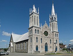
 Saint-Narcisse Church | |
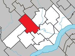
 Location within Les Chenaux RCM. | |
| Country | |
| Province | |
| Region | Mauricie |
| RCM | Les Chenaux |
| Constituted | July 1, 1855 |
| Government | |
| • Mayor | Guy Veillette |
| • Federal riding | Saint-Maurice—Champlain |
| • Prov. riding | Champlain |
| Area | |
• Total | 106.90 km2 (41.27 sq mi) |
| • Land | 104.87 km2 (40.49 sq mi) |
| Population (2011)[2] | |
• Total | 1,762 |
| • Density | 16.8/km2 (44/sq mi) |
| • Pop 2006-2011 | |
| • Dwellings | 818 |
| Time zone | UTC−5 (EST) |
| • Summer (DST) | UTC−4 (EDT) |
| Postal code(s) | |
| Area code(s) | 418 and 581 |
| Highways | |
Saint-Narcisse is a parish municipality located in the regional county municipality (MRC) Chenaux, in the administrative region of Mauricie, in the province of Quebec, in Canada.[4]. Located on the North Shore of the St. Lawrence River, about thirty kilometers from downtown Trois-Rivières, the parish of Saint-Narcisse is the heart of the Mauricie region.
With an area of 104.87 square kilometers, the city territory is divided by rows: Grande Ligne (Great line), the second highest rank Saint-Felix, Rang Sainte-Marguerite and rank Dam. The territory also includes the "lake Morin" (Popularly named "Petit lac" - Little Lake) which is located north of the Grande Ligne (Great Line). A line of mountains crosses the municipal territory along its entire length, separating the plate of Middle Mauricie with the plain of the Lower Mauricie.
Its watershed is mostly part of the Batiscanie, except the southwest area, the limit of Champlain and of Saint-Luc-de-Vincennes. The municipality is crossed by five rivers: Batiscan River, "Rivière-des-Chutes" (River of the falls), "Rivière-au-Lard" (Bacon River), "Rivière-aux-Fourches" (River of the forks), and "Rivière La Tortue" (Turtle River). The route of the "Turtle River" enter into Saint-Narcisse by the northwest end (row "Côte St-Pierre - Northeast area"), where it crosses four lots on 1.4 km. Then the river continues to flow in Saint-Séverin to go jump into the Rivière des Envies (River cravings).
Industry
The town is known for the making of mattresses, prefabricated homes, and the sale of farm tractors.
Demographics
| Year | Population | Variation (%) |
|---|---|---|
| 2011 | 1,762 | |
| 2006 | 1,806 | |
| 2001 | 1,858 | |
| 1996 | 1,937 | |
| 1991 | 1,995 | N/A |
Private dwellings occupied by usual residents: 798 (total dwellings: 818) Mother tongue:
• English as first language: 0.6%
• French as first language: 98.6%
• English and French as first language: 0%
• Other as first language: 0.8%
See also
References
- ^ a b "Répertoire des municipalités: Geographic code 37240". www.mamh.gouv.qc.ca (in French). Ministère des Affaires municipales et de l'Habitation.
- ^ a b "Saint-Narcisse (Code 2437240) Census Profile". 2011 census. Government of Canada - Statistics Canada.
- ^ "Banque de noms de lieux du Québec: Reference number 57277". toponymie.gouv.qc.ca (in French). Commission de toponymie du Québec.
- ^ Government of Quebec (January 11, 2011). "Saint-Narcisse". Ministry of Municipal Affairs, Regions and land Occupancy. municipal Directory.
- ^ Statistics Canada: 1996, 2001, 2006, 2011 census
External links
 Media related to Saint-Narcisse (Québec) at Wikimedia Commons
