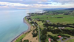
Whakatīwai
Whakatīwai | |
|---|---|
Locality | |
 Whakatīwai, looking south towards Kaiaua and Pūkorokoro / Miranda | |
 | |
| Coordinates: 37°5′S 175°18′E / 37.083°S 175.300°E | |
| Country | New Zealand |
| Region | Waikato |
| District | Hauraki District |
| Electorates | Coromandel Hauraki-Waikato |
| Area | |
• Total | 3.06 km2 (1.18 sq mi) |
| Population (2018 Census)[2] | 183 |
| Time zone | UTC+12 (NZST) |
| • Summer (DST) | UTC+13 (NZDT) |
| Postcode | 2473 |
| Area code | 09 |
Whakatīwai is a locality on the Seabird Coast on the western shore of the Firth of Thames, in the Hauraki District, New Zealand.[3] Whakatīwai is the location of Wharekawa Marae, which holds importance for Ngāti Paoa and Ngāti Whanaunga.[4] Whakatīwai Regional Park is just north of Whakatīwai. Until 2010, Whakatīwai was a part of the Franklin District. Because it was previously considered a part of the Auckland region, the Whakatīwai Regional Park continues to be owned and operated by the Auckland Council.[5]
History
[edit]
Whakatīwai is the site where the Tainui ancestor Hotunui settled, after exiling himself from the Kāwhia Harbour.[6] Hotunui's son Marutūahu established a pā at Whakatīwai, and Marutūahu's sons became the ancestors of the five tribes of the Marutūāhu collective.[6] Whakatīwai became a settlement of Ngāti Pāoa, one of the Marutūāhu tribes, and is called the poutokomanawa ("heart post") of the Ngāti Paoa rohe.[7] During the Musket Wars in 1821, the Ngāti Pāoa settlement at Whakatīwai was sacked.[8] Ngāti Pāoa continued to live in the area, and in 1827 Ngāti Pāoa sheltered Apihai Te Kawau, paramount chief of Ngāti Whātua, at Whakatīwai during the war.[9] In 1874, Ngāti Pāoa held a great hui at Whakatīwai for over 3,000 delegates to finalise the plans for opening the Ohinemuri goldfields in the Karangahake Gorge, which included speakers Wiremu Kīngi and Tareha Te Moananui and crown negotiator James Mackay.[10]
In the early 20th century, Whakatīwai was predominantly Māori, while Kaiaua directly to the south was predominantly Pākehā. Because of this, the Kaiaua School was moved to a location central for both townships in the 1930s.[4]
HMNZS Hinau (T17), a minesweeper from World War II, was beached at Stevenson's gravel quarry in the mid-1950s to serve as a breakwater. A photograph of the wreck featured on the cover of The Islander, a record album by Dave Dobbyn.
Demographics
[edit]Whakatīwai is in an SA1 statistical area which covers 3.06 km2 (1.18 sq mi)[1] and includes the area between Kaiaua School and Wharekawa Marae, but does not include Whakatīwai Regional Park or the Hinau wreck. The SA1 area is included in Kaiaua's demographics, and part of the larger Miranda-Pūkorokoro statistical area.[11]
| Year | Pop. | ±% p.a. |
|---|---|---|
| 2006 | 156 | — |
| 2013 | 177 | +1.82% |
| 2018 | 183 | +0.67% |
| Source: [2] | ||
The SA1 statistical area had a population of 183 at the 2018 New Zealand census, an increase of 6 people (3.4%) since the 2013 census, and an increase of 27 people (17.3%) since the 2006 census. There were 87 households, comprising 93 males and 87 females, giving a sex ratio of 1.07 males per female. The median age was 56.1 years (compared with 37.4 years nationally), with 21 people (11.5%) aged under 15 years, 15 (8.2%) aged 15 to 29, 90 (49.2%) aged 30 to 64, and 57 (31.1%) aged 65 or older.
Ethnicities were 83.6% European/Pākehā, 36.1% Māori, and 1.6% Pasifika. People may identify with more than one ethnicity.
Although some people chose not to answer the census's question about religious affiliation, 55.7% had no religion, 27.9% were Christian, 1.6% had Māori religious beliefs and 1.6% had other religions.
Of those at least 15 years old, 18 (11.1%) people had a bachelor's or higher degree, and 48 (29.6%) people had no formal qualifications. The median income was $24,900, compared with $31,800 nationally. 18 people (11.1%) earned over $70,000 compared to 17.2% nationally. The employment status of those at least 15 was that 66 (40.7%) people were employed full-time, 21 (13.0%) were part-time, and 6 (3.7%) were unemployed.[2]
References
[edit]- ^ a b "ArcGIS Web Application". statsnz.maps.arcgis.com. Retrieved 26 January 2024.
- ^ a b c "Statistical area 1 dataset for 2018 Census". Statistics New Zealand. March 2020. 7010813.
- ^ "Place name detail: Whakatīwai". New Zealand Gazetteer. New Zealand Geographic Board. Retrieved 20 September 2021.
- ^ a b EnviroStrat (May 2020). "Wharekawa Coast 2120: Natural Hazards Social Impact Assessment for Wharekawa" (PDF). Hauraki District Council. Retrieved 21 September 2021.
- ^ "Regional Parks Management Plan 2010" (PDF). Auckland Council. August 2010. Retrieved 20 September 2021.
- ^ a b Royal, Te Ahukaramū Charles (8 February 2005). "Marutūahu tribes". Te Ara. Retrieved 23 September 2021.
- ^ New Zealand Government; Ngāti Paoa (20 March 2021). "Ngāti Pāoa and the Trustees of the Ngāti Pāoa Iwi Trust and The Crown Deed of Settlement of Historical Claims" (PDF). New Zealand Government. Retrieved 1 September 2021.
- ^ Plowman, Mica (2009). "The Archaeology of the Clevedon Village and Wairoa River Valley" (PDF). Auckland Council. Retrieved 21 September 2021.
- ^ McClure, Margaret (1 August 2016). "Auckland region – Māori history". Te Ara. Retrieved 21 September 2021.
- ^ Nicholls, Betty (June 1974). "Historic Meeting at Whakatiwai". Ohinemuri Regional History Journals. 18.
- ^ 2018 Census place summary: Miranda-Pūkorokoro
