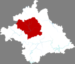
Wuming, Nanning
Wuming
武鸣区 · Vujmingz Gih | |
|---|---|
 Location in Nanning | |
| Coordinates: 23°09′32″N 108°16′26″E / 23.159°N 108.274°E[1] | |
| Country | China |
| Autonomous region | Guangxi |
| Prefecture-level city | Nanning |
| District seat | Chengxiang |
| Area | |
• Total | 3,378.36 km2 (1,304.39 sq mi) |
| Population | |
• Total | 722,000 |
| • Density | 210/km2 (550/sq mi) |
| Time zone | UTC+8 (China Standard) |
| Postal code | 5301XX |
Wuming District (simplified Chinese: 武鸣区; traditional Chinese: 武鳴區; pinyin: Wǔmíng Qū; Standard Zhuang: Vujmingz Gih) is one of 7 districts of the prefecture-level city of Nanning, the capital of Guangxi Zhuang Autonomous Region, South China. The district was approved to build from the dissolution of the former Wuming County (武鸣县) by the Chinese State Council on February 16, 2015.[5] Located north of the city proper, it borders the prefecture-level city of Baise to the west.
Administrative divisions
[edit]Wuming District is divided into 13 towns:[6]
- Chengxiang 城厢镇
- Taiping 太平镇
- Shuangqiao 双桥镇
- Ningwu 宁武镇
- Luoxu 锣圩镇
- Xianhu 仙湖镇
- Fucheng 府城镇
- Luwo 陆斡镇
- Liangjiang 两江镇
- Luobo 罗波镇
- Lingma 灵马镇
- Ganxu 甘圩镇
- Matou 马头镇
Language
[edit]Zhuang is the most widely spoken language of the district.[7] The Zhuang dialect spoken in Shuangqiao (双桥镇) in Wuming District is used as the basis for the pronunciation of Standard Zhuang.[7]
Several varieties of Chinese are spoken in Wuming, including Wuming Mandarin, Putonghua, Hengtang dialect (a dialect of Pinghua), Xinmin dialect (a dialect of Hakka) and Cantonese.[7]
Climate
[edit]| Climate data for Wuming (1991–2020 normals, extremes 1981–2010) | |||||||||||||
|---|---|---|---|---|---|---|---|---|---|---|---|---|---|
| Month | Jan | Feb | Mar | Apr | May | Jun | Jul | Aug | Sep | Oct | Nov | Dec | Year |
| Record high °C (°F) | 29.1 (84.4) |
34.5 (94.1) |
36.2 (97.2) |
37.7 (99.9) |
39.2 (102.6) |
38.2 (100.8) |
40.6 (105.1) |
38.7 (101.7) |
38.9 (102.0) |
36.3 (97.3) |
33.6 (92.5) |
29.7 (85.5) |
40.6 (105.1) |
| Mean daily maximum °C (°F) | 17.0 (62.6) |
19.1 (66.4) |
21.8 (71.2) |
27.4 (81.3) |
31.1 (88.0) |
32.7 (90.9) |
33.5 (92.3) |
33.6 (92.5) |
32.4 (90.3) |
29.2 (84.6) |
24.9 (76.8) |
19.8 (67.6) |
26.9 (80.4) |
| Daily mean °C (°F) | 13.2 (55.8) |
15.2 (59.4) |
18.1 (64.6) |
23.1 (73.6) |
26.5 (79.7) |
28.2 (82.8) |
28.8 (83.8) |
28.7 (83.7) |
27.4 (81.3) |
24.1 (75.4) |
19.7 (67.5) |
15.0 (59.0) |
22.3 (72.2) |
| Mean daily minimum °C (°F) | 10.6 (51.1) |
12.7 (54.9) |
15.7 (60.3) |
20.2 (68.4) |
23.4 (74.1) |
25.4 (77.7) |
25.8 (78.4) |
25.6 (78.1) |
24.0 (75.2) |
20.6 (69.1) |
16.3 (61.3) |
11.9 (53.4) |
19.4 (66.8) |
| Record low °C (°F) | 0.7 (33.3) |
2.5 (36.5) |
2.8 (37.0) |
8.7 (47.7) |
13.4 (56.1) |
16.8 (62.2) |
20.1 (68.2) |
20.8 (69.4) |
16.0 (60.8) |
10.0 (50.0) |
4.0 (39.2) |
0.4 (32.7) |
0.4 (32.7) |
| Average precipitation mm (inches) | 50.3 (1.98) |
35.7 (1.41) |
71.5 (2.81) |
71.1 (2.80) |
181.2 (7.13) |
231.5 (9.11) |
211.1 (8.31) |
175.4 (6.91) |
95.3 (3.75) |
62.8 (2.47) |
50.9 (2.00) |
35.5 (1.40) |
1,272.3 (50.08) |
| Average precipitation days (≥ 0.1 mm) | 10.0 | 10.5 | 14.5 | 12.2 | 14.1 | 16.3 | 16.6 | 14.9 | 9.2 | 6.6 | 6.7 | 7.3 | 138.9 |
| Average snowy days | 0.1 | 0 | 0 | 0 | 0 | 0 | 0 | 0 | 0 | 0 | 0 | 0 | 0.1 |
| Average relative humidity (%) | 76 | 77 | 80 | 77 | 77 | 79 | 78 | 78 | 74 | 71 | 72 | 71 | 76 |
| Mean monthly sunshine hours | 60.9 | 57.3 | 49.8 | 93.4 | 142.5 | 147.1 | 185.1 | 190.2 | 178.4 | 161.2 | 131.5 | 111.9 | 1,509.3 |
| Percent possible sunshine | 18 | 18 | 13 | 25 | 35 | 36 | 45 | 48 | 49 | 45 | 40 | 34 | 34 |
| Source: China Meteorological Administration[8][9] | |||||||||||||
References
[edit]- ^ "Wuming" (Map). Google Maps. Retrieved 2014-07-02.
- ^ Nanning City Land Use Plan (2006–20)/《南宁市土地利用总体规划(2006-2020年)》.(in Chinese) Accessed 8 July 2014.
- ^ 《中国2010年人口普查分县资料》 (in Chinese). 中国统计出版社. December 2012. ISBN 978-7-5037-6659-6.
- ^ 武鸣区人民政府门户网站 (2020-08-19). "武鸣年鉴2019年" (in Simplified Chinese). Archived from the original on 2021-07-09. Retrieved 2021-07-07.
- ^ 武鸣区历史沿革 (in Simplified Chinese). xzqh.org. 2015-11-17. Retrieved 2019-07-19.
- ^ 2023年统计用区划代码和城乡划分代码:武鸣区 (in Simplified Chinese). National Bureau of Statistics of China.
- ^ a b c Wuming County Annals Editorial Board, ed. (1998). 语言文字 [Spoken and Written Language]. 武鸣县志 [Wuming County Annals] (in Chinese). Nanning: Guangxi People's Publishing House. Volume 27, chapter 1, section 2. Retrieved 25 January 2020.
- ^ 中国气象数据网 – WeatherBk Data (in Simplified Chinese). China Meteorological Administration. Retrieved 28 May 2023.
- ^ 中国气象数据网 (in Simplified Chinese). China Meteorological Administration. Retrieved 28 May 2023.

