Файл:Libyan Civil War.svg
Перейти к навигации
Перейти к поиску
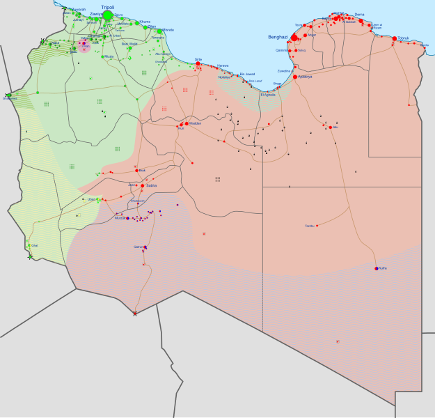
Размер этого PNG-превью для исходного SVG-файла: 625 × 600 пкс. Другие разрешения: 250 × 240 пкс | 500 × 480 пкс | 801 × 768 пкс | 1067 × 1024 пкс | 2135 × 2048 пкс | 1033 × 991 пкс.
Исходный файл (SVG-файл, номинально 1033 × 991 пкс, размер файла: 805 КБ)
История файла
Нажмите на дату/время, чтобы посмотреть файл, который был загружен в тот момент.
| Дата/время | Миниатюра | Размеры | Участник | Примечание | |
|---|---|---|---|---|---|
| 14:00, 11 июня 2016 | 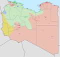 | 969 × 929 (500 КБ) | Ermanarich | Update, derived from the Template. Daesh is being wiped out of the country, their last stronghold Sirte is currently contested. We are witnessing the last breathes of these terrorists in Libya. | |
| 22:04, 3 июня 2016 |  | 969 × 929 (503 КБ) | Ermanarich | Update. Qasr Abu Hadi and Ghardabiya airbase directly south of Sirte are contested between Daesh-terrorists and a GNA-alligned militia (Al-Bunyan Al-Marsoos forces). Daesh is increasingly losing ground. | |
| 20:47, 2 июня 2016 |  | 969 × 929 (498 КБ) | Ermanarich | Update, derived from the Template. Daesh is losing ground, GNA-forces are close to Sirte! Again some colour changes: Blue is for local forces again, the PFG area green because the PFG is aff. with the GNA. | |
| 21:15, 22 мая 2016 |  | 969 × 929 (495 КБ) | Ermanarich | Update according to the Template and a colour change: Blue is now Petroleum Facilities Guard, orange regional forces. I hesitated long to do this, is it too complicated? What do you think? | |
| 16:55, 30 апреля 2016 |  | 969 × 929 (483 КБ) | Ermanarich | Update, derived from the Template. Abu Qurayn liberated from Daesh-terrorists, az-Zawiya and Sorman again under full control of the GNA, Tarhuna in the hands of tribal militias. Benghazi and Derna detailed... | |
| 19:25, 23 апреля 2016 |  | 969 × 929 (489 КБ) | Ermanarich | Update, derived from the Template. Daesh expands to Wadi Souf Al Jein south of Bani Walid, but was expelled from Derna. | |
| 15:09, 26 марта 2016 |  | 969 × 929 (482 КБ) | Ermanarich | al Qaryat is in the hands of Dignity, the Tobruk-based government. See the template. | |
| 23:41, 25 марта 2016 |  | 969 × 929 (481 КБ) | Ermanarich | Changes derived from the template, see there. I actually doubt that Daesh still attacks Maradah(little town contested between Dawn and Daesh), but I couldn't find sources which say that they are expelled. | |
| 16:03, 23 февраля 2016 |  | 969 × 929 (468 КБ) | Habarithor | LNA expelled islamists from ajdabiya | |
| 05:50, 21 февраля 2016 |  | 969 × 929 (467 КБ) | Oganesson007 | User created page with UploadWizard |
Использование файла
Следующие 2 страницы используют этот файл:
Глобальное использование файла
Данный файл используется в следующих вики:
- Использование в af.wikipedia.org
- Использование в ar.wikipedia.org
- Использование в be.wikipedia.org
- Использование в ca.wikipedia.org
- Использование в cs.wikipedia.org
- Использование в de.wikipedia.org
- Использование в el.wikipedia.org
- Использование в en.wikipedia.org
- Libya
- Portal:Libya
- User talk:Banak
- Arab Spring
- Khalifa Haftar
- User talk:Spesh531/Archive 2016
- User:Kopiersperre
- Libyan civil war (2014–2020)
- Libyan crisis (2011–present)
- Tuareg militias of Ghat
- Template:Libyan Civil War map
- Timeline of the Islamic State (2016)
- User:Oganesson007/Civil war maps
- List of armed groups in the Libyan civil war (2014–2020)
- Wikipedia:Graphics Lab/Map workshop/Archive/Mar 2018
- Freedom of religion in Africa by country
- Turkish intervention in Libya (2020–present)
- 2020s in military history
- Egyptian intervention in Libya (2015–2020)
- User:Edisonabcd/sandbox
- 2020s in African history
- Использование в eo.wikipedia.org
- Использование в es.wikipedia.org
Просмотреть глобальное использование этого файла.


