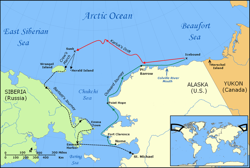
Файл:Karluk voyage map.png
Перейти к навигации
Перейти к поиску

Размер этого предпросмотра: 800 × 537 пкс. Другие разрешения: 320 × 215 пкс | 640 × 429 пкс | 1002 × 672 пкс.
Исходный файл (1002 × 672 пкс, размер файла: 198 КБ, MIME-тип: image/png)
История файла
Нажмите на дату/время, чтобы посмотреть файл, который был загружен в тот момент.
| Дата/время | Миниатюра | Размеры | Участник | Примечание | |
|---|---|---|---|---|---|
| текущий | 18:36, 30 января 2010 |  | 1002 × 672 (198 КБ) | Finetooth | Added black border to left edge. |
| 02:33, 28 января 2010 |  | 1002 × 672 (198 КБ) | Finetooth | Added directional arrow to map scale | |
| 02:12, 28 января 2010 |  | 1002 × 672 (198 КБ) | Finetooth | Added map scale, moved Bering Sea text slightly to reduce clutter | |
| 02:12, 28 января 2010 |  | 1002 × 672 (198 КБ) | Finetooth | Added map scale, moved Bering Sea text slightly to reduce clutter | |
| 18:07, 27 января 2010 |  | 1002 × 672 (195 КБ) | Finetooth | Corrected placement of Port Clarence, moved Arctic Ocean and Beaufort Sea labels to the right and changed font to match East Siberian Sea | |
| 05:42, 27 января 2010 |  | 1002 × 672 (184 КБ) | Finetooth | Cropped, added colour to outward voyage and drift in ice, increased font size of voyage-segment text to improve readability, added Emma Town, Port Hope, Port Clarence, mouth of the Colville River, Herald Island and Herschel Island, made Bartlett's journey | |
| 03:11, 26 января 2010 |  | 1200 × 672 (312 КБ) | Finetooth | {{Information |Description={{en|1=Map of the Voyage of the ''Karluk'', including the outbound journey from Nome, the ship's drift in Arctic pack ice, the crew's icy march to Wrangel Island, and Captain Bartlett's journey on foot from Wrangel Island to Emm |
Использование файла
Следующая страница использует этот файл:
Глобальное использование файла
Данный файл используется в следующих вики:
- Использование в en.wikipedia.org
- Использование в fr.wikipedia.org
- Использование в lv.wikipedia.org
- Использование в nl.wikipedia.org
- Использование в pt.wikipedia.org

