Перейти на страницу файла на Викискладе

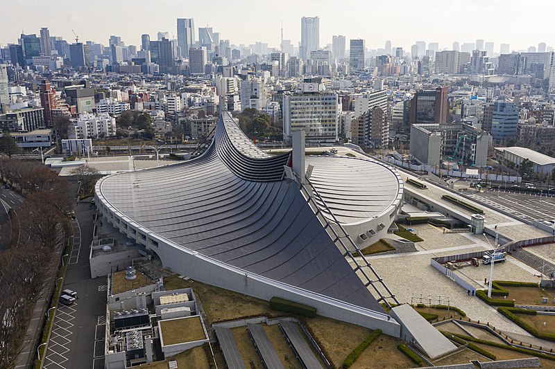
Файл:Kokuritsu Yoyogi Kyōgijō 1.jpg

Материал из Википедии — свободной энциклопедии
Перейти к навигации Перейти к поиску

Исходный файл (4412 × 2941 пкс, размер файла: 8,81 МБ, MIME-тип: image/jpeg)

Краткое описание

Описание
English: Aerial view of Kokuritsu Yoyogi Kyōgijō, Tokyo, Japan
Дата
Источник Собственная работа
Автор

© Arne Müseler

Arne Müseler    wikidata:Q78209280
 
Arne Müseler
Место рождения Unna (Германия)
Годы творчества С 1997
date QS:P,+1997-00-00T00:00:00Z/7,P580,+1997-00-00T00:00:00Z/9
Место творчества
Авторитетный файл
creator QS:P170,Q78209280
Права
(Повторное использование этого файла)
Объект

Japan

Reproduction of the architectural work(s) in this image is permitted under Section 46 of the Copyright Law of Japan, as long as it does not constitute "imitative reproduction of an architectural work and offering it to the public by transfer of ownership of its copies." This permission does not apply to artistic works in general or to buildings that are considered artistic works, unless they are in public domain. See COM:CRT/Japan#Freedom of panorama for more information.

العربية  English  日本語  한국어  中文(简体)  中文(繁體)  +/−

Фотография

I published this file as author under the Creative Commons License CC-by-SA-3.0.. This means that a ‘free use outside Wikimedia’s projects’ is only possible under the following conditions:

  • In print media:
    On the file/In the file credits: Photo/Map: Arne Müseler / arne-mueseler.com / CC-BY-SA-3.0 / https://creativecommons.org/licenses/by-sa/3.0/de/deed.de
    It is not sufficient to just mention my name. This is necessary in any case. Naming the author does not release from the obligation to properly license the photo. Also, a link to Wikipedia or Commons is not sufficient and counts as license violation.
    If a mention in this form is not possible, please contact me before a planned use.
  • In online media:
    On the file/In the file credits: Photo/Map: Arne Müseler / arne-mueseler.com / CC-BY-SA-3.0 (linked to: https://creativecommons.org/licenses/by-sa/3.0/de/deed.de)
    If possible, please link to my homepage: www.arne-mueseler.com
    It is not sufficient to just mention my name. This is necessary in any case. Naming the author does not release from the obligation to properly license the photo. Also, a link to Wikipedia or Commons is not sufficient and counts as license violation.
    A license notice by hovering over the file is not sufficient, as this is not displayed e.g. during mobile access. The license notice must always be visible.

I would be very grateful if you could send me a specimen copy of the photo/map or the details of the website where the photo/map will be used. Basically, all my photos and maps can be licensed under the conditions of the Mittelstandsgemeinschaft Foto-Marketing (MFM).

Please send an email to lizenz AT arne-mueseler.de if you

  • need the photo or map in a higher resolution,
  • require my address for sending a specimen copy,
  • want to use the photo or map for a fee, i.e. not under the license specified,
  • have further questions on license-compliant use.
Arne Müseler / www.arne-mueseler.com, владелец авторских прав на это произведение, добровольно публикует его на условиях следующей лицензии:
w:ru:Creative Commons
атрибуция распространение на тех же условиях
Этот файл доступен по лицензии Creative Commons Attribution-Share Alike 3.0 Германия.
Атрибуция: Arne Müseler / www.arne-mueseler.com
Вы можете свободно:
  • делиться произведением – копировать, распространять и передавать данное произведение
  • создавать производные – переделывать данное произведение
При соблюдении следующих условий:
  • атрибуция – Вы должны указать авторство, предоставить ссылку на лицензию и указать, внёс ли автор какие-либо изменения. Это можно сделать любым разумным способом, но не создавая впечатление, что лицензиат поддерживает вас или использование вами данного произведения.
  • распространение на тех же условиях – Если вы изменяете, преобразуете или создаёте иное произведение на основе данного, то обязаны использовать лицензию исходного произведения или лицензию, совместимую с исходной.
Местоположение камеры35° 40′ 03,61″ с. ш., 139° 42′ 00,63″ в. д. Kartographer map based on OpenStreetMap.Это и другие изображения по их местоположению на OpenStreetMapinfo

VI seal

Это изображение было оценено в соответствии с критериями ценных иллюстраций и было признано наиболее ценным изображением в категории Aerial view of Yoyogi National Gymnasium. Вы можете просмотреть его номинацию на странице Commons:Valued image candidates/Kokuritsu Yoyogi Kyōgijō 1.jpg.

Краткие подписи

Добавьте однострочное описание того, что собой представляет этот файл

Элементы, изображённые на этом файле

изображённый объект

35°40'3.608"N, 139°42'0.626"E

image/jpeg

История файла

Нажмите на дату/время, чтобы посмотреть файл, который был загружен в тот момент.

Дата/времяМиниатюраРазмерыУчастникПримечание
текущий15:29, 15 января 2020Миниатюра для версии от 15:29, 15 января 20204412 × 2941 (8,81 МБ)Arne Müseler{{Information |description={{en|1=Aerial view of Kokuritsu Yoyogi Kyōgijō, Tokyo, Japan}} |source={{own}} |Author={{User:Arne mueseler/Autor}} |Permission={{Template:ArneMueselerCredit}} |other_versions= }} {{Location|35.667669|139.700174}} Category:Kokuritsu Yoyogi Kyōgijō Category:Japan - Photographs by Arne Müseler

Глобальное использование файла

Данный файл используется в следующих вики:

Просмотреть глобальное использование этого файла.

Метаданные