西沃威克:修订间差异
外观
删除的内容 添加的内容
补救2个来源,并将0个来源标记为失效。) #IABot (v2.0.7 |
|||
| (未显示4个用户的7个中间版本) | |||
| 第1行: | 第1行: | ||
{{ |
{{NoteTA |
||
|1 = zh-hans:罗得岛;zh-hant:羅德島; |
|||
|G1=USState |
|||
|1=zh-hans:县;zh-hk:縣;zh-tw:郡; |
|||
|2=zh-cn:肯特;zh-hk:根德;zh-tw:肯特; |
|||
}} |
}} |
||
{{Infobox settlement |
{{Infobox settlement |
||
| |
|name = 西沃威克 |
||
|native_name = {{native name|en|West Warwick}} |
|||
|settlement_type = [[新英格蘭鎮|鎮]] |
|settlement_type = [[新英格蘭鎮|鎮]] |
||
|nickname = 羅德島的中心({{lang|en|The Center of Rhode Island}}) |
|nickname = 羅德島的中心({{lang|en|The Center of Rhode Island}}) |
||
|motto = |
|||
<!-- Images --> |
|||
|image_skyline = West_Warwick_Memorial.jpg |
|image_skyline = West_Warwick_Memorial.jpg |
||
|imagesize = 300px |
|imagesize = 300px |
||
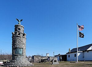
|image_caption = 西沃威克戰爭紀念公園({{lang|en|War Memorial Park West Warwick}}) |
|image_caption = 西沃威克戰爭紀念公園({{lang|en|War Memorial Park West Warwick}}) |
||
|image_flag = |
|||
|image_seal = |
|||
<!-- Maps --> |
|||
|image_map = Kent County Rhode Island incorporated and unincorporated areas West Warwick highlighted.svg |
|image_map = Kent County Rhode Island incorporated and unincorporated areas West Warwick highlighted.svg |
||
|map_caption = 西沃威克在[[羅德島州]]與[[肯特县 (罗得岛州)|肯特县]]的位置 |
|map_caption = 西沃威克在[[羅德島州]]與[[肯特县 (罗得岛州)|肯特县]]的位置 |
||
<!-- Location --> |
|||
|subdivision_type = 國家 |
|subdivision_type = 國家 |
||
|subdivision_name = [[美国]] |
|subdivision_name = [[美国]] |
||
| 第25行: | 第18行: | ||
|subdivision_type2 = [[羅德島州郡級行政區列表|縣份]] |
|subdivision_type2 = [[羅德島州郡級行政區列表|縣份]] |
||
|subdivision_name2 = [[肯特县 (罗得岛州)|肯特县]] |
|subdivision_name2 = [[肯特县 (罗得岛州)|肯特县]] |
||
<!-- Government --> |
|||
|government_footnotes = |
|||
|government_type = [[議會-經理制政府|議會-經理制]] |
|government_type = [[議會-經理制政府|議會-經理制]] |
||
|established_title1 = 設立 |
|established_title1 = 設立 |
||
| 第32行: | 第23行: | ||
|established_title2 = 成建制 |
|established_title2 = 成建制 |
||
|established_date2 = 1913年 |
|established_date2 = 1913年 |
||
<!-- Area --> |
|||
|unit_pref = Imperial |
|unit_pref = Imperial |
||
|area_footnotes = |
|||
|area_magnitude = |
|||
|area_total_km2 = |
|||
|area_land_km2 = 20.2 |
|area_land_km2 = 20.2 |
||
|area_water_km2 = |
|||
|area_total_sq_mi = |
|||
|area_land_sq_mi = 7.79 |
|area_land_sq_mi = 7.79 |
||
|area_water_sq_mi = |
|||
<!-- Population --> |
|||
|population_as_of = [[2010年美國人口普查|2010年]] |
|population_as_of = [[2010年美國人口普查|2010年]] |
||
|population_footnotes = |
|||
|population_total = 29,191 |
|population_total = 29,191 |
||
|population_density_km2 = 1,446.8 |
|population_density_km2 = 1,446.8 |
||
|population_density_sq_mi = 3,747.2 |
|population_density_sq_mi = 3,747.2 |
||
<!-- General information --> |
|||
|timezone = [[北美东部时区|EST]] |
|timezone = [[北美东部时区|EST]] |
||
|utc_offset = −5 |
|utc_offset = −5 |
||
|timezone_DST = EDT |
|timezone_DST = EDT |
||
|utc_offset_DST = −4 |
|utc_offset_DST = −4 |
||
|elevation_footnotes = |
|||
|elevation_m = 46 |
|elevation_m = 46 |
||
|elevation_ft = 151 |
|elevation_ft = 151 |
||
| 第64行: | 第44行: | ||
|blank1_name = [[地名信息系统|GNIS]]碼 |
|blank1_name = [[地名信息系统|GNIS]]碼 |
||
|blank1_info = 1220060<ref name="GR3">{{cite web|url=http://geonames.usgs.gov|accessdate=2008-01-31|title=US Board on Geographic Names|publisher=United States Geological Survey|date=2007-10-25|archive-date=2012-02-04|archive-url=https://web.archive.org/web/20120204035720/http://geonames.usgs.gov/|dead-url=no}}</ref> |
|blank1_info = 1220060<ref name="GR3">{{cite web|url=http://geonames.usgs.gov|accessdate=2008-01-31|title=US Board on Geographic Names|publisher=United States Geological Survey|date=2007-10-25|archive-date=2012-02-04|archive-url=https://web.archive.org/web/20120204035720/http://geonames.usgs.gov/|dead-url=no}}</ref> |
||
|website = |
|||
|footnotes = |
|||
}} |
}} |
||
| ⚫ | '''西沃威克'''<ref>{{世界地名译名词典 |entry=West Warwick 西沃威克 [美] |page=3118 }}</ref>({{lang-en|West Warwick}})是位於[[美国]][[羅德島州]][[肯特县 (罗得岛州)|肯特县]]的[[新英格蘭鎮|鎮]]<ref name="Census 2010">{{cite web|url=http://factfinder.census.gov/bkmk/table/1.0/en/DEC/10_SF1/GCTPH1.ST10/0400000US01|title=GCT-PH1 – Population, Housing Units, Area, and Density: 2010 – State — Place and (in selected states) County Subdivision|publisher=United States Census Bureau|work=2010 United States Census|access-date=2019-09-28|archive-url=https://web.archive.org/web/20200916215109/https://data.census.gov/cedsci/deeplinks?url=https%3A%2F%2Ffactfinder.census.gov%2Fbkmk%2Ftable%2F1.0%2Fen%2FDEC%2F10_SF1%2FGCTPH1.ST10%2F0400000US01|archive-date=2020-09-16|dead-url=yes}}</ref>,建立於1648年<ref name="RhodeIslandGovernment">{{cite web|url=https://www.ri.gov/towns/|title=Rhode Island Cities & Towns|publisher=Rhode Island Interactive|website=Rhode Island Government|access-date=2019-09-07|archive-url=https://web.archive.org/web/20190730203457/https://www.ri.gov/towns/|archive-date=2019-07-30|dead-url=no}}</ref>,2010年人口共29,191人,相對於2000年的人口(29,581人)減少了1.3%;面積20.2平方公里,人口密度1,446.8人/平方公里<ref name="Census 2010"/>。鎮政府實行[[議會-經理制政府|議會-經理制]]<ref name="RhodeIslandGovernment"/>,其行政長官為「經理」,由市鎮議會任命,並向市鎮議會負責<ref name="Council–Manager">{{cite web|url=http://www.coventryri.org/council-manager-form-of-government|title=Council–Manager Form of Government|publisher=Town of Coventry, Rhode Island|deadurl=yes|archiveurl=https://web.archive.org/web/20161119025138/http://coventryri.org/council-manager-form-of-government|archivedate=2016-11-19|access-date=2019-09-28}}</ref>。 |
||
| ⚫ | '''西沃威克'''({{lang-en|West Warwick}})是位於[[美国]][[羅德島州]][[肯特县 (罗得岛州)|肯特县]]的[[新英格蘭鎮|鎮]]<ref name="Census 2010">{{cite web|url=http://factfinder.census.gov/bkmk/table/1.0/en/DEC/10_SF1/GCTPH1.ST10/0400000US01|title=GCT-PH1 – Population, Housing Units, Area, and Density: 2010 – State — Place and (in selected states) County Subdivision|publisher=United States Census Bureau|work=2010 United States Census|access-date=2019-09-28|archive-url=https://archive. |
||
== 參考資料 == |
== 參考資料 == |
||
{{reflist}} |
{{reflist|30em}} |
||
== 外部連結 == |
== 外部連結 == |
||
* [http://www.westwarwickri.org Official West Warwick, Rhode Island Web Site] |
* [http://www.westwarwickri.org Official West Warwick, Rhode Island Web Site] {{Wayback|url=http://www.westwarwickri.org/ |date=20210506185933 }} |
||
* [https://web.archive.org/web/20060427003251/http://www.warwickri.gov/heritage/generalhistory.htm General History of Warwick, Rhode Island] |
* [https://web.archive.org/web/20060427003251/http://www.warwickri.gov/heritage/generalhistory.htm General History of Warwick, Rhode Island] |
||
{{Commonscat|West Warwick, Rhode Island}} |
{{Commonscat|West Warwick, Rhode Island}} |
||
2024年8月5日 (一) 10:06的最新版本
| 西沃威克 West Warwick(英語) | |
|---|---|
| 鎮 | |
 西沃威克戰爭紀念公園(War Memorial Park West Warwick) | |
| 綽號:羅德島的中心(The Center of Rhode Island) | |
 西沃威克在羅德島州與肯特县的位置 | |
| 坐标:41°42′N 71°31′W / 41.700°N 71.517°W | |
| 國家 | 美国 |
| 州份 | 羅德島州 |
| 縣份 | 肯特县 |
| 設立 | 1648年 |
| 成建制 | 1913年 |
| 政府 | |
| • 类型 | 議會-經理制 |
| 面积 | |
| • 陸地 | 7.79 平方英里(20.2 平方公里) |
| 海拔 | 151 英尺(46 公尺) |
| 人口(2010年) | |
| • 總計 | 29,191人 |
| • 密度 | 3,747.2人/平方英里(1,446.8人/平方公里) |
| 时区 | EST(UTC−5) |
| • 夏时制 | EDT(UTC−4) |
| 美國郵區編號 | 02893 |
| 電話區號 | 401 |
| FIPS碼 | 44-78440[1] |
| GNIS碼 | 1220060[2] |
西沃威克[3](英語:West Warwick)是位於美国羅德島州肯特县的鎮[4],建立於1648年[5],2010年人口共29,191人,相對於2000年的人口(29,581人)減少了1.3%;面積20.2平方公里,人口密度1,446.8人/平方公里[4]。鎮政府實行議會-經理制[5],其行政長官為「經理」,由市鎮議會任命,並向市鎮議會負責[6]。
參考資料
[编辑]- ^ American FactFinder. United States Census Bureau. [2008-01-31]. (原始内容存档于2013-09-11).
- ^ US Board on Geographic Names. United States Geological Survey. 2007-10-25 [2008-01-31]. (原始内容存档于2012-02-04).
- ^ 民政部地名研究所 (编). West Warwick 西沃威克 [美]. 世界地名译名词典. 北京: 中国社会出版社: 3118. 2017-05. ISBN 978-7-5087-5525-0. OCLC 1121629943. OL 28272719M. NLC 009152391.(简体中文)
- ^ 4.0 4.1 GCT-PH1 – Population, Housing Units, Area, and Density: 2010 – State — Place and (in selected states) County Subdivision. 2010 United States Census. United States Census Bureau. [2019-09-28]. (原始内容存档于2020-09-16).
- ^ 5.0 5.1 Rhode Island Cities & Towns. Rhode Island Government. Rhode Island Interactive. [2019-09-07]. (原始内容存档于2019-07-30).
- ^ Council–Manager Form of Government. Town of Coventry, Rhode Island. [2019-09-28]. (原始内容存档于2016-11-19).
