天安市:修订间差异
外观
删除的内容 添加的内容
內容擴充 |
→地理: 內容擴充 |
||
| 第49行: | 第49行: | ||
== 地理 == |
== 地理 == |
||
東靠[[車嶺山脈]],西部是平原。 |
東靠[[車嶺山脈]],西部是平原。 |
||
=== 氣候 === |
|||
{{Weather box |
|||
| location = 天安市 (東南區屏川面屏川里 天安地方氣象中心<ref>1972~1997 [[아산시]] [[온양]] 소재 관측소 자료이며, 1997년 천안시로 관측소를 이전하여 1997년~2015년은 [[신방동]] 소재, 2015년부터는 [[병천면]] 병천리 소재 관측소에서 관측</ref>) |
|||
| metric first = yes |
|||
| single line = yes |
|||
| Jan record high C = 16.5 |
|||
| Feb record high C = 22.2 |
|||
| Mar record high C = 26.7 |
|||
| Apr record high C = 31.2 |
|||
| May record high C = 33.9 |
|||
| Jun record high C = 34.8 |
|||
| Jul record high C = 37.7 |
|||
| Aug record high C = 37.8 |
|||
| Sep record high C = 33.9 |
|||
| Oct record high C = 28.7 |
|||
| Nov record high C = 25.3 |
|||
| Dec record high C = 19.1 |
|||
| year record high C = 37.8 |
|||
| Jan high C = 3.0 |
|||
| Feb high C = 5.8 |
|||
| Mar high C = 11.8 |
|||
| Apr high C = 18.7 |
|||
| May high C = 24.1 |
|||
| Jun high C = 27.5 |
|||
| Jul high C = 29.5 |
|||
| Aug high C = 30.2 |
|||
| Sep high C = 26.1 |
|||
| Oct high C = 20.4 |
|||
| Nov high C = 12.8 |
|||
| Dec high C = 5.2 |
|||
| year high C = 17.9 |
|||
| Jan mean C = -2.4 |
|||
| Feb mean C = 0.0 |
|||
| Mar mean C = 5.3 |
|||
| Apr mean C = 11.7 |
|||
| May mean C = 17.5 |
|||
| Jun mean C = 21.8 |
|||
| Jul mean C = 24.9 |
|||
| Aug mean C = 25.2 |
|||
| Sep mean C = 20.2 |
|||
| Oct mean C = 13.4 |
|||
| Nov mean C = 6.5 |
|||
| Dec mean C = -0.2 |
|||
| year mean C = 12.0 |
|||
| Jan low C = -7.5 |
|||
| Feb low C = -5.4 |
|||
| Mar low C = -0.8 |
|||
| Apr low C = 4.9 |
|||
| May low C = 11.4 |
|||
| Jun low C = 16.8 |
|||
| Jul low C = 21.2 |
|||
| Aug low C = 21.3 |
|||
| Sep low C = 15.2 |
|||
| Oct low C = 7.4 |
|||
| Nov low C = 1.0 |
|||
| Dec low C = -5.1 |
|||
| year low C = 6.7 |
|||
| Jan record low C = -23.9 |
|||
| Feb record low C = -19.9 |
|||
| Mar record low C = -10.4 |
|||
| Apr record low C = -5.2 |
|||
| May record low C = 2.0 |
|||
| Jun record low C = 6.9 |
|||
| Jul record low C = 12.5 |
|||
| Aug record low C = 12.1 |
|||
| Sep record low C = 3.0 |
|||
| Oct record low C = -4.3 |
|||
| Nov record low C = -10.4 |
|||
| Dec record low C = -18.7 |
|||
| year record low C = -23.9 |
|||
| precipitation colour = green |
|||
| Jan precipitation mm = 19.0 |
|||
| Feb precipitation mm = 27.0 |
|||
| Mar precipitation mm = 38.3 |
|||
| Apr precipitation mm = 67.5 |
|||
| May precipitation mm = 78.7 |
|||
| Jun precipitation mm = 127.0 |
|||
| Jul precipitation mm = 284.1 |
|||
| Aug precipitation mm = 299.7 |
|||
| Sep precipitation mm = 146.4 |
|||
| Oct precipitation mm = 55.5 |
|||
| Nov precipitation mm = 47.6 |
|||
| Dec precipitation mm = 27.9 |
|||
| year precipitation mm = 1218.7 |
|||
| unit precipitation days = 0.1 mm |
|||
| Jan precipitation days = 7.4 |
|||
| Feb precipitation days = 6.2 |
|||
| Mar precipitation days = 7.4 |
|||
| Apr precipitation days = 7.9 |
|||
| May precipitation days = 7.6 |
|||
| Jun precipitation days = 8.5 |
|||
| Jul precipitation days = 14.1 |
|||
| Aug precipitation days = 13.7 |
|||
| Sep precipitation days = 8.8 |
|||
| Oct precipitation days = 6.0 |
|||
| Nov precipitation days = 9.1 |
|||
| Dec precipitation days = 9.6 |
|||
| year precipitation days = |
|||
| Jan humidity = 68.5 |
|||
| Feb humidity = 63.8 |
|||
| Mar humidity = 61.1 |
|||
| Apr humidity = 58.2 |
|||
| May humidity = 62.3 |
|||
| Jun humidity = 69.1 |
|||
| Jul humidity = 77.2 |
|||
| Aug humidity = 76.7 |
|||
| Sep humidity = 74.0 |
|||
| Oct humidity = 71.2 |
|||
| Nov humidity = 70.0 |
|||
| Dec humidity = 69.5 |
|||
| year humidity = 68.5 |
|||
| Jan sun = 167.2 |
|||
| Feb sun = 178.4 |
|||
| Mar sun = 211.6 |
|||
| Apr sun = 221.5 |
|||
| May sun = 241.5 |
|||
| Jun sun = 207.3 |
|||
| Jul sun = 160.5 |
|||
| Aug sun = 184.0 |
|||
| Sep sun = 179.8 |
|||
| Oct sun = 204.8 |
|||
| Nov sun = 159.2 |
|||
| Dec sun = 155.5 |
|||
| year sun = 2271.3 |
|||
| source = [[韓國氣象廳]] (正常值: 1991~2020, 極端值: 1972年至今)<ref> |
|||
{{웹 인용 |
|||
| url = https://data.kma.go.kr/climate/average30Years/selectAverage30YearsKoreaList.do?pgmNo=188 |
|||
| publisher = 기상청 |
|||
| accessdate = 2021-03-25 |
|||
| title = 우리나라 기후평년값(1991~2020) 천안(232)}}</ref><ref> |
|||
{{웹 인용 |
|||
| url = https://data.kma.go.kr/climate/extremum/selectExtremumList.do?pgmNo=103 |
|||
| publisher = 기상청 |
|||
| accessdate = 2021-10-02 |
|||
| title = 순위값 - 구역별조회 천안(232)}}</ref> |
|||
}} |
|||
== 歷史 == |
== 歷史 == |
||
2024年8月30日 (五) 18:55的最新版本
| 天安市 | |
|---|---|
| 特例市 | |
| 韓語轉寫 | |
| • 諺文 | 천안시 |
| • 漢字 | 天安市 |
| • 文化观光部2000年式 | Cheonan-si |
| • 馬科恩-賴肖爾表記法 | Ch'ŏnan-si |
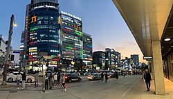
 新富洞街景 | |
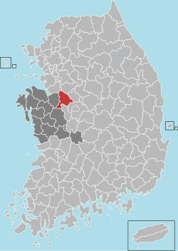
 天安市在韓國及忠清南道的位置 | |
| 坐标:36°48′36″N 127°08′51″E / 36.81°N 127.1475°E | |
| 國家 | |
| 地區 | 湖西地方 |
| 省份 | 忠清南道 |
| 行政區劃 | 2區、16洞、4邑、8面 |
| 政府 | |
| • 市長 | 朴商敦 ( |
| • 國會議員 | |
| 面积 | |
| • 总计 | 636.5 平方公里(245.8 平方英里) |
| 人口(2021年4月[1]) | |
| • 總計 | 657,410人 |
| • 密度 | 1,033人/平方公里(2,675人/平方英里) |
| • 方言 | 忠清方言 |
| 市樹 | 朝鮮垂柳 |
| 市花 | 韓國連翹 |
| 市鳥 | 鳩鴿 |
天安市(朝鮮語:천안시/天安市 Cheonan si */?),是大韓民國忠清南道北部的一個城市,位於首都首爾和大田之間。面積636.5平方公里,全市人口657,410人(2021年4月),為目前忠清南道人口最多的行政區。下分2區、16洞、4邑、8面。
天安市是韓國獨立女烈士柳寬順的故鄉。有獨立紀念館。天安市亦有聞名全韓國的美食,例如竝川血腸、天安核桃菓子等。同時,天安也是梨子、葡萄等水果的重要產地,畜牧業也很發達。
地理
[编辑]東靠車嶺山脈,西部是平原。
氣候
[编辑]| 天安市 (東南區屏川面屏川里 天安地方氣象中心[2]) | |||||||||||||
|---|---|---|---|---|---|---|---|---|---|---|---|---|---|
| 月份 | 1月 | 2月 | 3月 | 4月 | 5月 | 6月 | 7月 | 8月 | 9月 | 10月 | 11月 | 12月 | 全年 |
| 历史最高温 °C(°F) | 16.5 (61.7) |
22.2 (72.0) |
26.7 (80.1) |
31.2 (88.2) |
33.9 (93.0) |
34.8 (94.6) |
37.7 (99.9) |
37.8 (100.0) |
33.9 (93.0) |
28.7 (83.7) |
25.3 (77.5) |
19.1 (66.4) |
37.8 (100.0) |
| 平均高温 °C(°F) | 3.0 (37.4) |
5.8 (42.4) |
11.8 (53.2) |
18.7 (65.7) |
24.1 (75.4) |
27.5 (81.5) |
29.5 (85.1) |
30.2 (86.4) |
26.1 (79.0) |
20.4 (68.7) |
12.8 (55.0) |
5.2 (41.4) |
17.9 (64.2) |
| 日均气温 °C(°F) | −2.4 (27.7) |
0.0 (32.0) |
5.3 (41.5) |
11.7 (53.1) |
17.5 (63.5) |
21.8 (71.2) |
24.9 (76.8) |
25.2 (77.4) |
20.2 (68.4) |
13.4 (56.1) |
6.5 (43.7) |
−0.2 (31.6) |
12.0 (53.6) |
| 平均低温 °C(°F) | −7.5 (18.5) |
−5.4 (22.3) |
−0.8 (30.6) |
4.9 (40.8) |
11.4 (52.5) |
16.8 (62.2) |
21.2 (70.2) |
21.3 (70.3) |
15.2 (59.4) |
7.4 (45.3) |
1.0 (33.8) |
−5.1 (22.8) |
6.7 (44.1) |
| 历史最低温 °C(°F) | −23.9 (−11.0) |
−19.9 (−3.8) |
−10.4 (13.3) |
−5.2 (22.6) |
2.0 (35.6) |
6.9 (44.4) |
12.5 (54.5) |
12.1 (53.8) |
3.0 (37.4) |
−4.3 (24.3) |
−10.4 (13.3) |
−18.7 (−1.7) |
−23.9 (−11.0) |
| 平均降水量 mm(英寸) | 19.0 (0.75) |
27.0 (1.06) |
38.3 (1.51) |
67.5 (2.66) |
78.7 (3.10) |
127.0 (5.00) |
284.1 (11.19) |
299.7 (11.80) |
146.4 (5.76) |
55.5 (2.19) |
47.6 (1.87) |
27.9 (1.10) |
1,218.7 (47.98) |
| 平均降水天数(≥ 0.1 mm) | 7.4 | 6.2 | 7.4 | 7.9 | 7.6 | 8.5 | 14.1 | 13.7 | 8.8 | 6.0 | 9.1 | 9.6 | 106.3 |
| 平均相對濕度(%) | 68.5 | 63.8 | 61.1 | 58.2 | 62.3 | 69.1 | 77.2 | 76.7 | 74.0 | 71.2 | 70.0 | 69.5 | 68.5 |
| 月均日照時數 | 167.2 | 178.4 | 211.6 | 221.5 | 241.5 | 207.3 | 160.5 | 184.0 | 179.8 | 204.8 | 159.2 | 155.5 | 2,271.3 |
| 数据来源:韓國氣象廳 (正常值: 1991~2020, 極端值: 1972年至今)[3][4] | |||||||||||||
歷史
[编辑]天安市稷山邑是三韓時期馬韓中心“月支國”的所在地。大約在930年前後已有天安之稱。1963年1月1日設市。
交通
[编辑]鐵路有京釜線經過,這裡也是長項線的北起點。韓國高鐵設天安牙山站。高速公路方面有京釜高速公路和論山天安高速公路。首都圈電鐵其中一個終站也設在天安。
旅遊
[编辑]天安的旅遊資源豐富,交通也十分便利,首都圈電鐵1號線可一車直達。著名旅遊景點包括韓國獨立運動紀念館、覺願寺、天安常綠度假村等。
姐妹城市
[编辑]参见
[编辑]- 天安艦(以天安市命名,2010年爆炸沉沒,致發南北韓危機)


