羅斯巴德縣:修订间差异
补救2个来源,并将0个来源标记为失效。) #IABot (v2.0 |
补救5个来源,并将0个来源标记为失效。) #IABot (v2.0.8.8 |
||
| 第25行: | 第25行: | ||
}} |
}} |
||
'''羅斯布德縣'''({{lang en|'''Rosebud County'''}})是[[美國]][[蒙大拿州]]東南部的一個縣。面積13,020平方公里。根据[[美國2010年人口普查|2010年人口普查]],共有人口9,233人。本縣縣治為[[福賽斯 (蒙大拿州)|福賽斯]]{{GR|6}},而位於福賽斯內的縣法院則於1986年4月17日獲登陸[[國家史蹟名錄]]。<ref name=bulletin>"[http://www.cr.nps.gov/nr/publications/bulletins/nrb15/nrb15.pdf National Register Criteria for Evaluation]," ([[PDF]]), National Register Bulletins, ''National Park Service''. Retrieved March 22, 2007.</ref> |
'''羅斯布德縣'''({{lang en|'''Rosebud County'''}})是[[美國]][[蒙大拿州]]東南部的一個縣。面積13,020平方公里。根据[[美國2010年人口普查|2010年人口普查]],共有人口9,233人。本縣縣治為[[福賽斯 (蒙大拿州)|福賽斯]]{{GR|6}},而位於福賽斯內的縣法院則於1986年4月17日獲登陸[[國家史蹟名錄]]。<ref name=bulletin>"[http://www.cr.nps.gov/nr/publications/bulletins/nrb15/nrb15.pdf National Register Criteria for Evaluation] {{Wayback|url=http://www.cr.nps.gov/nr/publications/bulletins/nrb15/nrb15.pdf |date=20131204012839 }}," ([[PDF]]), National Register Bulletins, ''National Park Service''. Retrieved March 22, 2007.</ref> |
||
本縣成立於1901年2月11日,縣名來自[[羅斯布德河]]{{GR|3}},而羅斯布德河名稱貽來自河岸茂盛的[[薔薇]]。<ref>Kane, J. N. and C. C. Aiken. The American Counties: Origins of County Names Dates of Creation and Population Data 1950-2000. Lanham, MD.: Scarecrow Press, 2005. </ref> |
本縣成立於1901年2月11日,縣名來自[[羅斯布德河]]{{GR|3}},而羅斯布德河名稱貽來自河岸茂盛的[[薔薇]]。<ref>Kane, J. N. and C. C. Aiken. The American Counties: Origins of County Names Dates of Creation and Population Data 1950-2000. Lanham, MD.: Scarecrow Press, 2005. </ref> |
||
| 第68行: | 第68行: | ||
|2000= 9383 |
|2000= 9383 |
||
|2010= 9233 |
|2010= 9233 |
||
| footnote=<ref>{{cite web|url=http://www.census.gov/population/www/censusdata/cencounts/files/ca190090.txt|title=1900-1990 census data|publisher=United States Census Bureau|accessdate=2013-05-06}}</ref><ref>{{cite web|url=http://factfinder2.census.gov |title=American FactFinder |publisher=Factfinder2.census.gov |date= |accessdate=2013-02-16}}</ref><ref>{{cite web|url=http://mapserver.lib.virginia.edu/ |title=University of Virginia Library |publisher=Mapserver.lib.virginia.edu |date= |accessdate=2013-02-16}}</ref> |
| footnote=<ref>{{cite web|url=http://www.census.gov/population/www/censusdata/cencounts/files/ca190090.txt|title=1900-1990 census data|publisher=United States Census Bureau|accessdate=2013-05-06|archive-date=2013-06-18|archive-url=https://web.archive.org/web/20130618102118/http://www.census.gov/population/www/censusdata/cencounts/files/ca190090.txt}}</ref><ref>{{cite web |url=http://factfinder2.census.gov |title=American FactFinder |publisher=Factfinder2.census.gov |date= |accessdate=2013-02-16 |archive-date=2013-09-11 |archive-url=https://web.archive.org/web/20130911234518/http://factfinder2.census.gov/ }}</ref><ref>{{cite web |url=http://mapserver.lib.virginia.edu/ |title=University of Virginia Library |publisher=Mapserver.lib.virginia.edu |date= |accessdate=2013-02-16 |archive-date=2012-08-11 |archive-url=https://web.archive.org/web/20120811110448/http://mapserver.lib.virginia.edu/ }}</ref> |
||
|}} |
|}} |
||
根據[[2000年美國人口普查|2000年人口普查]]{{GR|2}},羅斯布德縣擁有9,383居民、3,307住戶和2,417家庭。<ref>{{en}}[http://www.census.gov/population/www/pop-profile/profile2000.html Population Profile of the United States: 2000] {{Wayback|url=http://www.census.gov/population/www/pop-profile/profile2000.html |date=20040113065424 }}</ref>其[[人口密度]]為每平方英里2居民(每平方公里1居民)。<ref>[http://censtats.census.gov/data/MI/05026003.pdf Statistical profile of Alger County, Michigan] {{webarchive|url=https://web.archive.org/web/20120407012422/http://censtats.census.gov/data/MI/05026003.pdf |date=2012-04-07 }}, United States Census Bureau, Census 2000</ref>本縣擁有3,912間房屋单位,其密度為每平方英里1間(每平方公里0.3間)。<ref>{{en}}[http://quickfacts.census.gov/qfd/ State and County QuickFacts] {{Wayback|url=http://quickfacts.census.gov/qfd/ |date=20040401125638 }}</ref>而人口是由64.4%[[歐裔美國人|白人]]、0.23%[[非裔美國人|黑人]]、32.41%[[美國土著|土著]]、0.29%[[亞裔美國人|亞洲人]]、0.65%其他[[種族]]和2.01%[[混血]][[种族构成|构成]]。而[[西班牙裔美国人|西班牙裔]]或[[拉丁美洲人]]佔了人口2.33%。在64.4%白人中,有19.8%為[[德國人]]、7.2%為[[愛爾蘭人]]、7.1%為[[英國人]]、以及6.9%為[[挪威人]]。87.6%人口的母語為[[英語]]、8.3%為[[夏安語]]、1.9%為[[西班牙語]]以及1%為[[德語]]。<ref>{{en}}[http://www.census.gov/main/www/cen2000.html Census 2000 gateway]</ref> |
根據[[2000年美國人口普查|2000年人口普查]]{{GR|2}},羅斯布德縣擁有9,383居民、3,307住戶和2,417家庭。<ref>{{en}}[http://www.census.gov/population/www/pop-profile/profile2000.html Population Profile of the United States: 2000] {{Wayback|url=http://www.census.gov/population/www/pop-profile/profile2000.html |date=20040113065424 }}</ref>其[[人口密度]]為每平方英里2居民(每平方公里1居民)。<ref>[http://censtats.census.gov/data/MI/05026003.pdf Statistical profile of Alger County, Michigan] {{webarchive|url=https://web.archive.org/web/20120407012422/http://censtats.census.gov/data/MI/05026003.pdf |date=2012-04-07 }}, United States Census Bureau, Census 2000</ref>本縣擁有3,912間房屋单位,其密度為每平方英里1間(每平方公里0.3間)。<ref>{{en}}[http://quickfacts.census.gov/qfd/ State and County QuickFacts] {{Wayback|url=http://quickfacts.census.gov/qfd/ |date=20040401125638 }}</ref>而人口是由64.4%[[歐裔美國人|白人]]、0.23%[[非裔美國人|黑人]]、32.41%[[美國土著|土著]]、0.29%[[亞裔美國人|亞洲人]]、0.65%其他[[種族]]和2.01%[[混血]][[种族构成|构成]]。而[[西班牙裔美国人|西班牙裔]]或[[拉丁美洲人]]佔了人口2.33%。在64.4%白人中,有19.8%為[[德國人]]、7.2%為[[愛爾蘭人]]、7.1%為[[英國人]]、以及6.9%為[[挪威人]]。87.6%人口的母語為[[英語]]、8.3%為[[夏安語]]、1.9%為[[西班牙語]]以及1%為[[德語]]。<ref>{{en}}[http://www.census.gov/main/www/cen2000.html Census 2000 gateway] {{Wayback|url=http://www.census.gov/main/www/cen2000.html |date=20190331194847 }}</ref> |
||
在3,307住户中,有38.7%擁有一個或以上的兒童(18歲以下)、56%為夫妻、11.8%為單親家庭、26.9%為非家庭、24.3%為獨居、8.4%住戶有同居長者。平均每戶有2.81人,而平均每個家庭則有3.34人。在9,383居民中,有33.5%為18歲以下、7.2%為18至24歲、25.7%為25至44歲、24.8%為45至64歲以及8.9%為65歲以上。人口的年齡中位數為34歲,女子對男子的性別比為100:100.9。成年人的性別比則為100:99.2。<ref name="Census">{{en}}[http://factfinder.census.gov American FactFinder] {{WebCite|url=https://www.webcitation.org/65jESGrbU?url=http://factfinder2.census.gov/legacy/aff_sunset.html |date=20120226005920 |dateformat=iso }}</ref> |
在3,307住户中,有38.7%擁有一個或以上的兒童(18歲以下)、56%為夫妻、11.8%為單親家庭、26.9%為非家庭、24.3%為獨居、8.4%住戶有同居長者。平均每戶有2.81人,而平均每個家庭則有3.34人。在9,383居民中,有33.5%為18歲以下、7.2%為18至24歲、25.7%為25至44歲、24.8%為45至64歲以及8.9%為65歲以上。人口的年齡中位數為34歲,女子對男子的性別比為100:100.9。成年人的性別比則為100:99.2。<ref name="Census">{{en}}[http://factfinder.census.gov American FactFinder] {{WebCite|url=https://www.webcitation.org/65jESGrbU?url=http://factfinder2.census.gov/legacy/aff_sunset.html |date=20120226005920 |dateformat=iso }}</ref> |
||
2022年7月14日 (四) 06:53的版本
| 羅斯巴德縣 羅斯布德縣 | |
|---|---|
| Map of 蒙大拿州 highlighting 羅斯布德縣 {{{CN_county}}}于{{{CN_state}}}中的位置 | |
| Map of the United States highlighting 蒙大拿州 {{{CN_state}}}于美国的位置 | |
| 坐标:46°14′N 106°43′W / 46.23°N 106.72°W | |
| 国家 | |
| 州 | |
| 设立日期 | 1901年2月11日 |
| 县治 | 福塞斯 |
| 最大城市 | 科爾斯特里普 |
| 人口(2010年) | |
| • 總計 | 9,233人 |
| 網站 | www |
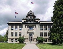
羅斯布德縣(英語:Rosebud County)是美國蒙大拿州東南部的一個縣。面積13,020平方公里。根据2010年人口普查,共有人口9,233人。本縣縣治為福賽斯[1],而位於福賽斯內的縣法院則於1986年4月17日獲登陸國家史蹟名錄。[2]
本縣成立於1901年2月11日,縣名來自羅斯布德河[3],而羅斯布德河名稱貽來自河岸茂盛的薔薇。[4]
地理

根據2000年人口普查,羅斯布德縣的總面積為5,027平方英里(13,020平方公里),其中有5,012平方英里(12,980平方公里),即99.71%為陸地;15平方英里(39平方公里),即0.29%為水域。[5]本縣既是蒙大拿州面積第五大的縣份,亦是美國面積第62大的縣份。
毗鄰縣
因為羅斯布德縣位於蒙大拿州中部,因此所有毗鄰縣皆為蒙大拿州的縣份。
國家保護區
- 卡斯特國家森林公園(部分)
人口
| 调查年 | 人口 | 备注 | %± |
|---|---|---|---|
| 1910 | 7,985 | — | |
| 1920 | 8,002 | 0.2% | |
| 1930 | 7,347 | −8.2% | |
| 1940 | 6,477 | −11.8% | |
| 1950 | 6,570 | 1.4% | |
| 1960 | 6,187 | −5.8% | |
| 1970 | 6,032 | −2.5% | |
| 1980 | 9,899 | 64.1% | |
| 1990 | 10,505 | 6.1% | |
| 2000 | 9,383 | −10.7% | |
| 2010 | 9,233 | −1.6% | |
| [6][7][8] | |||
根據2000年人口普查[9],羅斯布德縣擁有9,383居民、3,307住戶和2,417家庭。[10]其人口密度為每平方英里2居民(每平方公里1居民)。[11]本縣擁有3,912間房屋单位,其密度為每平方英里1間(每平方公里0.3間)。[12]而人口是由64.4%白人、0.23%黑人、32.41%土著、0.29%亞洲人、0.65%其他種族和2.01%混血构成。而西班牙裔或拉丁美洲人佔了人口2.33%。在64.4%白人中,有19.8%為德國人、7.2%為愛爾蘭人、7.1%為英國人、以及6.9%為挪威人。87.6%人口的母語為英語、8.3%為夏安語、1.9%為西班牙語以及1%為德語。[13]
在3,307住户中,有38.7%擁有一個或以上的兒童(18歲以下)、56%為夫妻、11.8%為單親家庭、26.9%為非家庭、24.3%為獨居、8.4%住戶有同居長者。平均每戶有2.81人,而平均每個家庭則有3.34人。在9,383居民中,有33.5%為18歲以下、7.2%為18至24歲、25.7%為25至44歲、24.8%為45至64歲以及8.9%為65歲以上。人口的年齡中位數為34歲,女子對男子的性別比為100:100.9。成年人的性別比則為100:99.2。[14]
本县的住戶收入中位數為$35,898,而家庭收入中位數則為$41,631。男性的收入中位數為$38,688 ,而女性的收入中位數則為$20,640,人均收入為$15,032。約17.8%家庭和22.4%人口在貧窮線以下,包括31.8%兒童(18歲以下)及15.1%長者(65歲以上)。[14]
参考文献
- ^ Find a County. National Association of Counties. [2011-06-07].
- ^ "National Register Criteria for Evaluation (页面存档备份,存于互联网档案馆)," (PDF), National Register Bulletins, National Park Service. Retrieved March 22, 2007.
- ^ US Board on Geographic Names. United States Geological Survey. 2007-10-25 [2008-01-31].
- ^ Kane, J. N. and C. C. Aiken. The American Counties: Origins of County Names Dates of Creation and Population Data 1950-2000. Lanham, MD.: Scarecrow Press, 2005.
- ^ Census 2000 U.S. Gazetteer Files: Counties. United States Census. [2011-02-13]. (原始内容存档于2012-06-06).
- ^ 1900-1990 census data. United States Census Bureau. [2013-05-06]. (原始内容存档于2013-06-18).
- ^ American FactFinder. Factfinder2.census.gov. [2013-02-16]. (原始内容存档于2013-09-11).
- ^ University of Virginia Library. Mapserver.lib.virginia.edu. [2013-02-16]. (原始内容存档于2012-08-11).
- ^ American FactFinder. United States Census Bureau. [2008-01-31].
- ^ (英文)Population Profile of the United States: 2000 (页面存档备份,存于互联网档案馆)
- ^ Statistical profile of Alger County, Michigan 互联网档案馆的存檔,存档日期2012-04-07., United States Census Bureau, Census 2000
- ^ (英文)State and County QuickFacts (页面存档备份,存于互联网档案馆)
- ^ (英文)Census 2000 gateway (页面存档备份,存于互联网档案馆)
- ^ 14.0 14.1 (英文)American FactFinder Archived 2012-02-26 at WebCite
