奧馬:修订间差异
外观
删除的内容 添加的内容
| 第27行: | 第27行: | ||
1998年,奧馬糟受[[汽車炸彈]]襲擊,造成29人死亡,220人受傷。 |
1998年,奧馬糟受[[汽車炸彈]]襲擊,造成29人死亡,220人受傷。 |
||
==气候== |
|||
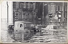
[[File:Omagh Flooding (1969).jpg|right|thumb|1969年洪水]] |
[[File:Omagh Flooding (1969).jpg|right|thumb|1969年洪水]] |
||
奥马历史上洪水频发,有记录以来,1909、1929、1954、1969、1987、1999、2007都有发生洪。其气候属于西海岸海洋气候([[柯本气候分类法]]:Cfb)。<ref>{{cite web|url=http://www.weatherbase.com/weather/weather-summary.php3?s=591403&cityname=Omagh,%20Northern%20Ireland,%20United%20Kingdom&units=|title=Travel Weather Averages (Weatherbase)|website=Weatherbase.com|access-date=20 October 2016|archive-date=23 September 2021|archive-url=https://web.archive.org/web/20210923152757/https://www.weatherbase.com/|url-status=live}}</ref> |
奥马历史上洪水频发,有记录以来,1909、1929、1954、1969、1987、1999、2007都有发生洪水。其气候属于西海岸海洋气候([[柯本气候分类法]]:Cfb)。<ref>{{cite web|url=http://www.weatherbase.com/weather/weather-summary.php3?s=591403&cityname=Omagh,%20Northern%20Ireland,%20United%20Kingdom&units=|title=Travel Weather Averages (Weatherbase)|website=Weatherbase.com|access-date=20 October 2016|archive-date=23 September 2021|archive-url=https://web.archive.org/web/20210923152757/https://www.weatherbase.com/|url-status=live}}</ref> |
||
{{Weather box |
{{Weather box |
||
|location = 奥马 |
|location = 奥马 |
||
2023年3月20日 (一) 09:31的版本
| Omagh | |
|---|---|
 | |
奧馬在北爱尔兰的位置 | |
| 坐标:54°36′00″N 7°18′09″W / 54.6°N 7.3025°W | |
| 主權國家 | 英国 |
| 國家 | 北愛爾蘭 |
| 人口[3] | |
| • 總計 | 21,297人 |
| 郵鎮(郵區) | OMAGH(BT78, BT79) |
| 電話區號 | 028 |
| 網站 | Official website |
| 區 | |
| 郡 | |
| 警察 | 北愛爾蘭警察局 |
| 消防 | 北愛爾蘭消防與救援機構 |
| 救護 | 北愛爾蘭救護機構 |
| 英國國會選區 | |
| 北愛爾蘭議會選區 |
|
奧馬(英語:Omagh)是英國北愛爾蘭的一座城市,也是蒂龍郡的郡治。奧馬位於北愛爾蘭西部,距離北愛爾蘭首府貝爾法斯特有68英里(109.5公里),距離倫敦德里則有34英里(55公里)。全市有人口21,297人[4],也是蒂龍郡的最大城市。
历史
1998年,奧馬糟受汽車炸彈襲擊,造成29人死亡,220人受傷。
气候

奥马历史上洪水频发,有记录以来,1909、1929、1954、1969、1987、1999、2007都有发生洪水。其气候属于西海岸海洋气候(柯本气候分类法:Cfb)。[5]
| 奥马 | |||||||||||||
|---|---|---|---|---|---|---|---|---|---|---|---|---|---|
| 月份 | 1月 | 2月 | 3月 | 4月 | 5月 | 6月 | 7月 | 8月 | 9月 | 10月 | 11月 | 12月 | 全年 |
| 平均高温 °C(°F) | 8 (46) |
9 (48) |
10 (50) |
12 (54) |
16 (61) |
18 (64) |
19 (66) |
19 (66) |
17 (63) |
13 (55) |
10 (50) |
8 (46) |
13 (55) |
| 平均低温 °C(°F) | 2 (36) |
2 (36) |
3 (37) |
3 (37) |
6 (43) |
9 (48) |
11 (52) |
11 (52) |
9 (48) |
6 (43) |
4 (39) |
2 (36) |
6 (43) |
| 平均降水量 mm(英寸) | 120 (4.7) |
79 (3.1) |
79 (3.1) |
74 (2.9) |
71 (2.8) |
69 (2.7) |
76 (3) |
64 (2.5) |
86 (3.4) |
120 (4.8) |
99 (3.9) |
120 (4.6) |
1,050 (41.4) |
| 数据来源:Weatherbase [6] | |||||||||||||
友好城市
參考資料
- ^ 2006 annual report in Ulster-Scots – North/South Ministerial Council (PDF). Northsouthministerialcouncil.org. [20 October 2016]. (原始内容 (PDF)存档于2013-02-27).
- ^ Guide to Beaghmore stone circles – Ulster-Scots (PDF). Department of the Environment. [20 October 2016]. (原始内容存档 (PDF)于2015-10-01).
- ^ Foundation, Internet Memory. [ARCHIVED CONTENT] Internet Memory - PRONI Web Archive. webarchive.proni.gov.uk. [2018-06-14]. (原始内容存档于2015-06-09).
- ^ 存档副本. [2014-08-07]. (原始内容存档于2014-08-10).
- ^ Travel Weather Averages (Weatherbase). Weatherbase.com. [20 October 2016]. (原始内容存档于23 September 2021).
- ^ Weatherbase.com. Weatherbase. 2013 [12 July 2013]. (原始内容存档于23 September 2021). Retrieved on 12 July 2013.

