1996年太平洋颱風季:修订间差异
Mauricengan(留言 | 贡献) |
Mauricengan(留言 | 贡献) |
||
| 第91行: | 第91行: | ||
{{clear}} |
{{clear}} |
||
=== |
=== 熱帶風暴載儀 === |
||
{{Infobox hurricane small new |
|||
|Basin=WPac |
|||
|Track=Ian 1996 track.png |
|||
|Formed=July 28 |
|||
|Dissipated=July 31 |
|||
|1-min winds=40 |
|||
}} |
|||
{{clear}} |
|||
===颱風卻克=== |
===颱風卻克=== |
||
{{Infobox hurricane small new |
{{Infobox hurricane small new |
||
| 第103行: | 第111行: | ||
}} |
}} |
||
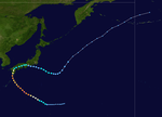
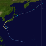
A monsoon depression developed on [[July 28]] over the open Pacific Ocean. It headed northwestward, slowly consolidating to become a tropical storm on the 5th. While south of Japan, Kirk drifted to the southeast and looped back to the west, strengthening to a typhoon on the 8th while looping. It continued slowly northwestward, and while curving to the northeast Kirk reached a peak of 110 mph winds. The typhoon struck southwestern Japan at that intensity on the 14th. It weakened over the country, and dissipated on the 16th over the northern Pacific. Kirk caused heavy flooding, resulting in at least 2 deaths and moderate damage.<ref name="CH3"/> |
A monsoon depression developed on [[July 28]] over the open Pacific Ocean. It headed northwestward, slowly consolidating to become a tropical storm on the 5th. While south of Japan, Kirk drifted to the southeast and looped back to the west, strengthening to a typhoon on the 8th while looping. It continued slowly northwestward, and while curving to the northeast Kirk reached a peak of 110 mph winds. The typhoon struck southwestern Japan at that intensity on the 14th. It weakened over the country, and dissipated on the 16th over the northern Pacific. Kirk caused heavy flooding, resulting in at least 2 deaths and moderate damage.<ref name="CH3"/> |
||
{{clear}} |
|||
<div style="clear: both"></div> |
|||
=== 熱帶低氣壓麗莎 === |
=== 熱帶低氣壓麗莎 === |
||
===熱帶風暴馬田=== |
=== 熱帶風暴馬田 (Marty) === |
||
{{Infobox hurricane small new |
{{Infobox hurricane small new |
||
|Basin=WPac |
|Basin=WPac |
||
| 第116行: | 第124行: | ||
}} |
}} |
||
The monsoon trough spawned a tropical depression over southern China on [[August 11]]。It drifted southwestward, entering the Gulf of Tonkin on the 12th. An extremely small cyclone, it reached tropical storm strength on the 13th and a peak of 60 mph on the 14th. Marty made landfall on the 14th on northern Vietnam, where it dissipated 3 days later. Though small and somewhat weak, Marty managed to cause moderate damage and flooding, amounting to the deaths of 125 with 107 people missing.<ref name="CH3"/> |
The monsoon trough spawned a tropical depression over southern China on [[August 11]]。It drifted southwestward, entering the Gulf of Tonkin on the 12th. An extremely small cyclone, it reached tropical storm strength on the 13th and a peak of 60 mph on the 14th. Marty made landfall on the 14th on northern Vietnam, where it dissipated 3 days later. Though small and somewhat weak, Marty managed to cause moderate damage and flooding, amounting to the deaths of 125 with 107 people missing.<ref name="CH3"/> |
||
{{clear}} |
|||
<div style="clear: both"></div> |
|||
=== 颱風麗潔 === |
=== 颱風麗潔 === |
||
| 第122行: | 第130行: | ||
=== 熱帶風暴佩萍 === |
=== 熱帶風暴佩萍 === |
||
=== 熱帶風暴歷克 (Rick) === |
=== 熱帶風暴歷克 (Rick) === |
||
{{infobox |
{{infobox hurricane small new |
||
|Basin=WPac |
|Basin=WPac |
||
|Track=Rick 1996 track.png |
|Track=Rick 1996 track.png |
||
| 第131行: | 第139行: | ||
{{clear}} |
{{clear}} |
||
=== 颱風莎莉 === |
=== 颱風莎莉 (Sally) === |
||
{{Infobox hurricane small new |
{{Infobox hurricane small new |
||
|Basin=WPac |
|Basin=WPac |
||
2009年9月18日 (五) 15:39的版本
| 1996年太平洋颱風季 | |
|---|---|
| 氣旋季長度 | |
| 首個系統形成 | {{{First storm formed}}} |
| 末個系統消散 | {{{Last storm dissipated}}} |
| 氣旋季統計 | |
| 死亡人數 | 不明 |
| 財產損失 | 不明 |
1996年太平洋颱風季泛指在1996年全年內的任何時間,於赤道以北及國際換日線以西的太平洋水域所產生的熱帶氣旋。雖然有關方面並沒有設下本颱風季的指定期限,但大部份於西北太平洋的熱帶氣旋通常都會於六月至十二月期間形成。
本條目的範圍僅侷限於赤道以北及國際換日線以西的太平洋水域。於赤道以北及國際換日線以東的太平洋水域產生的風暴則被稱為颶風。在西太平洋產生的熱帶風暴是由聯合颱風警報中心命名,而在該地區的熱帶低氣壓的編號都以 W 字母作結。而凡進入或產生於菲律賓風暴責任範圍以內的熱帶低氣壓,菲律賓大氣地理天文部門 (PAGASA) 都會為它們訂立一個菲律賓名稱,作當地警報用途;因此同一個風暴有時候會有兩個不同的名稱。
以下各熱帶氣旋資訊以熱帶氣存在期間的最強形態為準。
| 區域專責氣象中心東京颱風中心 熱帶氣旋等級 | ||||
|---|---|---|---|---|
| 等級 | 風速 | |||
| 猛烈颱風 | ≥105節 ≥194公里每小時 | |||
| 强烈颱風 | 85–104節 157–193公里每小時 | |||
| 颱風 | 64–84節 118–156公里每小時 | |||
| 強烈熱帶風暴 | 48–63節 88–117公里每小時 | |||
| 熱帶風暴 | 34–47節 63–87公里每小時 | |||
| 熱帶低氣壓 | 22–33節 41–62公里每小時 | |||
熱帶氣旋
熱帶風暴安茵
| 熱帶風暴(SSHWS) | |
| 持續日期 | 1996年4月2日-1996年4月9日 |
|---|---|
| 強度 | 75 km/h(45 mph) (一分鐘) |
颱風巴特
熱帶風暴錦雯
颱風丹尼
颱風伊芙 (Eve)
| 5級 超級 颱風(SSHWS) | |
| 持續日期 | 1996年7月13日-1996年7月20日 |
|---|---|
| 強度 | 260 km/h(160 mph) (一分鐘) 898 hPa(mbar) |
A Tropical Upper Tropospheric Trough spawned Tropical Depression 7W on July 10 over the open Western Pacific. It tracked generally west-northwestward, strengthening to a tropical storm on the 13th. On the 14th Eve became a typhoon, which was followed by a period of explosive deepening to a 160 mph Super Typhoon, with a pressure drop of 70 mb from early on the 15th to early on the 16th. An eyewall replacement cycle weakened Eve to a 115 mph typhoon, but as the outer eyewall contracted, the storm again reached wind speeds of 135 mph before hitting southern Japan on the 18th. Rapidly weakening over the mountains, Eve turned eastward over the islands and the last warning was issued on the 20th. It restrengthened to a tropical storm east of Japan, and continued northeastward until dissipation on the 27th. Eve, despite being a Category 4 at landfall, caused no reported deaths and only 9 injuries.[1]
颱風法蘭基 (Frankie)
| 2級 颱風(SSHWS) | |
| 持續日期 | 1996年7月21日-1996年7月24日 |
|---|---|
| 強度 | 165 km/h(105 mph) (一分鐘) 954 hPa(mbar) |
An active monsoon trough over the Western Pacific Ocean developed 3 typhoons; Frankie, Gloria, and Herb. The first, Frankie, developed in the South China Sea on July 19。It tracked west-northwestward and became a tropical storm on the 21st. After crossing the island of Hainan Frankie rapidly intensified to a 100 mph typhoon over the Gulf of Tonkin。It northern Vietnam on the 23rd, and dissipated 2 days later over China. 104 people were reported killed or missing in association with Frankie, and damage figures are estimated at over $200 million (1996 US Dollars).[1]
颱風姬羅莉亞
| 2級 颱風(SSHWS) | |
| 持續日期 | 1996年7月22日-1996年7月27日 |
|---|---|
| 強度 | 165 km/h(105 mph) (一分鐘) 954 hPa(mbar) |
The same monsoon trough that spawned Frankie also spawned a tropical depression on July 19 east of the Philippines。It headed northwestward, slowly organizing into a tropical storm on the 22nd. The next day Gloria reached typhoon strength, and a day later it reached its peak of 100 mph winds. Gloria brushed the northern coast of the Philippines and turned northward to hit Taiwan on the 26th. After crossing the island and the Taiwan Straight, Gloria hit China where she dissipated on the 27th. Gloria caused 23 casualties, 20 of which were in the northern Philippines. In addition, damage was estimated at $20 million (1996 USD).[1]
颱風赫拔 (Herb)
| 5級 超級 颱風(SSHWS) | |
| 持續日期 | 1996年7月23日-1996年8月1日 |
|---|---|
| 強度 | 260 km/h(160 mph) (一分鐘) 898 hPa(mbar) |
7月23日熱帶性低氣壓10W在塞班島附近形成,先往北移動,而後往西。熱帶低氣壓10W在7月24日增強為熱帶風暴赫拔。熱帶風暴赫拔持續往西移動,並在7月25日增強為颱風。由於與颱風姬羅莉亞的藤原效應,赫拔的風速有所減慢。但在那之後,颱風赫拔又再度增強,並在7月30日發展為超級颱風。颱風赫拔是1996年最大的颱風,也是自1977年以來第8大的颱風。
颱風侵襲的琉球群島,並在7月31日在台灣北部登陸。8月1日登陸中國後,颱風赫拔迅速減弱,並在8月3日消散。
熱帶風暴載儀
| 熱帶風暴(SSHWS) | |
| 持續日期 | July 28-July 31 |
|---|---|
| 強度 | 75 km/h(45 mph) (一分鐘) |
颱風卻克
| 2級 颱風(SSHWS) | |
| 持續日期 | 1996年8月3日-1996年8月16日 |
|---|---|
| 強度 | 175 km/h(110 mph) (一分鐘) 949 hPa(mbar) |
A monsoon depression developed on July 28 over the open Pacific Ocean. It headed northwestward, slowly consolidating to become a tropical storm on the 5th. While south of Japan, Kirk drifted to the southeast and looped back to the west, strengthening to a typhoon on the 8th while looping. It continued slowly northwestward, and while curving to the northeast Kirk reached a peak of 110 mph winds. The typhoon struck southwestern Japan at that intensity on the 14th. It weakened over the country, and dissipated on the 16th over the northern Pacific. Kirk caused heavy flooding, resulting in at least 2 deaths and moderate damage.[1]
熱帶低氣壓麗莎
熱帶風暴馬田 (Marty)
| 熱帶風暴(SSHWS) | |
| 持續日期 | 1996年8月13日-1996年8月14日 |
|---|---|
| 強度 | 85 km/h(50 mph) (一分鐘) 991 hPa(mbar) |
The monsoon trough spawned a tropical depression over southern China on August 11。It drifted southwestward, entering the Gulf of Tonkin on the 12th. An extremely small cyclone, it reached tropical storm strength on the 13th and a peak of 60 mph on the 14th. Marty made landfall on the 14th on northern Vietnam, where it dissipated 3 days later. Though small and somewhat weak, Marty managed to cause moderate damage and flooding, amounting to the deaths of 125 with 107 people missing.[1]
颱風麗潔
颱風奧臣
熱帶風暴佩萍
熱帶風暴歷克 (Rick)
| 熱帶風暴(SSHWS) | |
| 持續日期 | August 28-August 31 |
|---|---|
| 強度 | 65 km/h(40 mph) (一分鐘) |
颱風莎莉 (Sally)
| 5級 超級 颱風(SSHWS) | |
| 持續日期 | 1996年9月2日-1996年9月9日 |
|---|---|
| 強度 | 260 km/h(160 mph) (一分鐘) 898 hPa(mbar) |
一個熱帶低氣壓在9月2日於菲律賓以東海域形成。該熱帶低氣壓以西北偏西方向移動,並在9月5日增強為熱帶風暴及於6日增強為颱風。在9月7日颱風莎莉迅速增強其中心風力達每小時160海浬之超級颱風,並橫過菲律賓。當進入南中國海時,莎莉的中心風力略減為每小時115海浬。莎莉於9月9日在雷州半島登陸,並在翌日消散。莎莉為中國大陸帶來連場狂風暴雨和破壞,導致114人死亡﹑110人失蹤,經濟損失估計約達15億美元(1996年值)。[1]
颱風湯姆
颱風維奧莉
颱風威利 (Willie)
| 1級 颱風(SSHWS) | |
| 持續日期 | September 17-September 23 |
|---|---|
| 強度 | 120 km/h(75 mph) (一分鐘) 985 hPa(mbar) |
An active monsoon trough that also developed Typhoons Tom (25W) and Violet (26W) spawned a tropical depression in the Gulf of Tonkin on September 16。It moved counter-clockwise around Hainan Island,becoming a tropical storm on the 17th and a typhoon on the 19th. It crossed the narrow Hainan Straight between Hainan and China, and continued west-southwestward across the Gulf of Tonkin. Willie made landfall on Vietnam on the 22nd, and dissipated the next day. The typhoon resulted in 38 fatalities from flooding.[1]
颱風雅芝
颱風贊寧
颱風雅貝爾
颱風貝芙
颱風卡路
颱風汀露
熱帶風暴安里 (Ernie)
PAGASA:Toyang
| 熱帶風暴(SSHWS) | |
| 持續日期 | November 4-November 17 |
|---|---|
| 強度 | 95 km/h(60 mph) (一分鐘) |
熱帶風暴芳雅
熱帶風暴格雷 (Greg)
| 熱帶風暴(SSHWS) | |
| 持續日期 | December 24-December 27 |
|---|---|
| 強度 | 75 km/h(45 mph) (一分鐘) 991 hPa(mbar) |
Two active monsoon troughs that also developed Typhoon Fern and Southern Hemisphere Cyclones Ophelia, Phil, and Fergus spawned Tropical Depression 43W in the South China Sea on December 21。Due to the troughs' nature, the depression headed east-southeastward, where it strengthened into the final tropical storm of the year on the 24th; Greg. After reaching a peak of 50 mph winds it crossed the northern part of Borneo on the 25th. It continued east-southeastward until dissipation on the 27th, south of the Philippines. Greg caused extensive property damage on Borneo from torrential flooding, resulting in 127 deaths and 100 people missing.[1]
其它熱帶氣旋
除了被命名的熱帶氣旋外,還有一些沒被命名的熱帶低氣壓的熱帶氣旋。以下列出那些熱帶氣旋的資料。
參考文獻
- ^ 1.0 1.1 1.2 1.3 1.4 1.5 1.6 1.7 Joint Typhoon Warning Center. Chapter 3. Retrieved on 2007-01-07.
內部連結
- 1996年大西洋颶風季
- 1996年太平洋颶風季
- 1996年北印度洋氣旋季
- 1995-1996年西南印度洋熱帶氣旋季
- 1995-1996年澳洲地區熱帶氣旋季
- 1995-1996年南太平洋熱帶氣旋季
- 1996-1997年西南印度洋熱帶氣旋季
- 1996-1997年澳洲地區熱帶氣旋季
- 1996-1997年南太平洋熱帶氣旋季


