托尔巴省:修订间差异
外观
删除的内容 添加的内容
小 使用DisamAssist清理消歧義連結:省会(改連結至首府)。 |
Ohtashinichiro(留言 | 贡献) 翻译外文链接 |
||
| 第1行: | 第1行: | ||
{{Infobox settlement |
|||
| ⚫ | |||
|name=彭纳马省 |
|||
| ⚫ | |||
|type=省 |
|||
|image_flag=Flag of Torba Province.svg |
|||
| ⚫ | |||
|map_caption=在瓦努阿图的位置 |
|||
|subdivision_name={{VAN}} |
|||
|subdivision_type=国家 |
|||
|seat_type=首府 |
|||
|seat={{le|Sola, Vanuatu||Sola}} |
|||
|area_total_km2=882 |
|||
|population_as_of=2009 |
|||
|population=9359 |
|||
}} |
|||
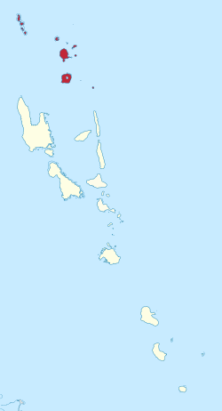
| ⚫ | '''托尔巴省'''({{lang-en|Torba}})是[[瓦努阿图]]最北端的[[省]]。由[[班克斯群岛]]({{lang|en|Banks}})与[[托雷斯群島]]({{lang|en|Torres}})组成。托尔巴({{lang|en|Torba}})一词来自班克斯群岛({{lang|en|Banks}})与托雷斯群島({{lang|en|Torres}})的合称。该省人口9359<ref>{{cite web | url=http://www.spc.int/prism/country/vu/stats/Publications/2009%20Census%20Summary%20release%20final.pdf | title=2009 National Census of Population and Housing: Summary Release| publisher=Vanuatu National Statistics Office | year=2009 | access-date= October 11, 2010}}</ref> ,总面积882 km²。该省[[首府|省会]]为{{le|Sola, Vanuatu||索拉}}。 |
||
==岛屿== |
|||
[[File:Vanuatu-Torres-Banks.png|thumb|left|300px]] |
|||
;班克斯群岛(Banks Islands) |
|||
{| class="wikitable sortable" |
|||
|- |
|||
! 名称 !! 人口 !! 面积(km<sup>2</sup>) |
|||
|- |
|||
| [[加瓦島]] || 2,491 || 342 |
|||
|- |
|||
| {{tsl|en|Kwakéa||Kwakéa}} || 26 || 1.2 |
|||
|- |
|||
| [[梅雷拉瓦島]] || 647 || 18 |
|||
|- |
|||
| [[梅里格島]] || 12 || 0.5 |
|||
|- |
|||
| [[莫塔島]] || 683 || 9.5 |
|||
|- |
|||
| [[莫塔拉瓦島]] || 1,451 || 24 |
|||
|- |
|||
| [[拉島]] || 189 || 0.5 |
|||
|- |
|||
| [[帕拉帕拉島]] || 437 || 39 |
|||
|- |
|||
| [[瓦努阿拉瓦島]] || 2,597 || 314 |
|||
|} |
|||
;托雷斯群岛(Torres Islands) |
|||
{| class="wikitable sortable" |
|||
|- |
|||
! 名称 !! 人口 !! 面积(km<sup>2</sup>) |
|||
|- |
|||
| [[希烏島]] || 269 || 51 |
|||
|- |
|||
| [[利努瓦島]] || 0 || 2.5 |
|||
|- |
|||
| [[洛島]] || 210 || 11.9 |
|||
|- |
|||
| [[梅托馬島]] || 13 || 3 |
|||
|- |
|||
| [[特瓜島]] || 58 || 30.8 |
|||
|- |
|||
| [[托加島]] || 276 || 18.8 |
|||
|} |
|||
==语言== |
|||
托尔巴省有 17 种语言<ref>{{Harvcoltxt|François|2012}}.</ref><ref>[http://alex.francois.online.fr/AF-field.htm List and map of the 17 languages of Torba province].</ref> ,全部为[[大洋洲語族]]。从北到南:Hiw、Lo-Toga、Lehali、Löyöp、Volow、Mwotlap、Lemerig、Vera'a、Vurës、Mwesen、Mota、Nume、Dorig、Koro、Olrat、Lakon、Mwerlap。<ref>{{Citation| last1 = François| first1 = Alexandre| last2 =Franjieh| first2 =Michael| last3 =Lacrampe| first3 =Sébastien| last4 =Schnell| first4 =Stefan| editor-last =François| editor-first =Alexandre| editor2-last =Lacrampe| editor2-first =Sébastien| editor3-last =Franjieh| editor3-first =Michael| editor4-last =Schnell| editor4-first =Stefan| date =2015| title =The Languages of Vanuatu: Unity and Diversity| chapter =The exceptional linguistic density of Vanuatu| contribution-url =http://alex.francois.online.fr/data/Francois-et-al_2015_Languages-of-Vanuatu_Intro-chapter.pdf| series =Studies in the Languages of Island Melanesia| publisher =Asia Pacific Linguistics Open Access| location =Canberra| pages = 1–21| hdl = 1885/14819| isbn =9781922185235| url = https://hdl.handle.net/1885/14819| ref = density}}.</ref> |
|||
每种语言平均有550人使用,托尔巴是瓦努阿图语言最密集的地区之一,而瓦努阿图本身就是世界上人均语言密度最高的国家。 |
|||
==参考资料== |
|||
{{refs}} |
|||
{{coord|display=title}} |
|||
{{瓦努阿图行政区划}} |
{{瓦努阿图行政区划}} |
||
[[Category:托尔巴省]] |
[[Category:托尔巴省]] |
||
[[Category:萬那杜省份]] |
|||
2022年2月3日 (四) 05:12的版本
| 彭纳马省 | |
|---|---|
| 省 | |
 在瓦努阿图的位置 | |
| 坐标:13°45′S 167°30′E / 13.75°S 167.5°E | |
| 国家 | |
| 首府 | Sola |
| 面积 | |
| • 总计 | 882 平方公里(341 平方英里) |
| 人口(2009) | 9,359人 |
托尔巴省(英語:Torba)是瓦努阿图最北端的省。由班克斯群岛(Banks)与托雷斯群島(Torres)组成。托尔巴(Torba)一词来自班克斯群岛(Banks)与托雷斯群島(Torres)的合称。该省人口9359[1] ,总面积882 km²。该省省会为索拉。
岛屿

- 班克斯群岛(Banks Islands)
| 名称 | 人口 | 面积(km2) |
|---|---|---|
| 加瓦島 | 2,491 | 342 |
| Kwakéa | 26 | 1.2 |
| 梅雷拉瓦島 | 647 | 18 |
| 梅里格島 | 12 | 0.5 |
| 莫塔島 | 683 | 9.5 |
| 莫塔拉瓦島 | 1,451 | 24 |
| 拉島 | 189 | 0.5 |
| 帕拉帕拉島 | 437 | 39 |
| 瓦努阿拉瓦島 | 2,597 | 314 |
- 托雷斯群岛(Torres Islands)
| 名称 | 人口 | 面积(km2) |
|---|---|---|
| 希烏島 | 269 | 51 |
| 利努瓦島 | 0 | 2.5 |
| 洛島 | 210 | 11.9 |
| 梅托馬島 | 13 | 3 |
| 特瓜島 | 58 | 30.8 |
| 托加島 | 276 | 18.8 |
语言
托尔巴省有 17 种语言[2][3] ,全部为大洋洲語族。从北到南:Hiw、Lo-Toga、Lehali、Löyöp、Volow、Mwotlap、Lemerig、Vera'a、Vurës、Mwesen、Mota、Nume、Dorig、Koro、Olrat、Lakon、Mwerlap。[4]
每种语言平均有550人使用,托尔巴是瓦努阿图语言最密集的地区之一,而瓦努阿图本身就是世界上人均语言密度最高的国家。
参考资料
- ^ 2009 National Census of Population and Housing: Summary Release (PDF). Vanuatu National Statistics Office. 2009 [October 11, 2010].
- ^ François (2012).
- ^ List and map of the 17 languages of Torba province.
- ^ François, Alexandre; Franjieh, Michael; Lacrampe, Sébastien; Schnell, Stefan, The exceptional linguistic density of Vanuatu (PDF), François, Alexandre; Lacrampe, Sébastien; Franjieh, Michael; Schnell, Stefan (编), The Languages of Vanuatu: Unity and Diversity, Studies in the Languages of Island Melanesia, Canberra: Asia Pacific Linguistics Open Access: 1–21, 2015, ISBN 9781922185235, hdl:1885/14819.


