賴加德縣:修订间差异
外观
删除的内容 添加的内容
补救1个来源,并将0个来源标记为失效。) #IABot (v2.0.8 |
内容扩充 |
||
| 第3行: | 第3行: | ||
{{Expand language|1=en|time=2020-08-28T02:25:37+00:00}} |
{{Expand language|1=en|time=2020-08-28T02:25:37+00:00}} |
||
}} |
}} |
||
{{Infobox settlement |
|||
| ⚫ | |||
| name = 赖加德县 |
|||
| settlement_type = [[马哈拉施特拉邦]]的[[马哈拉施特拉邦行政区划|县]] |
|||
| total_type = Total |
|||
| native_name = रायगड जिल्हा |
|||
| image_skyline = {{Photomontage |
|||
|size = 250 |
|||
|photo1a = Elephanta Cave 3 2.jpg |
|||
|photo1b = PanoramaPointView.JPG |
|||
|photo2a = Shivaji statue, Alibag 03.jpg |
|||
|photo2b = Kalamboli image1.jpg |
|||
|photo3a = Hills Views From Raigad.jpg |
|||
}} |
|||
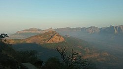
| image_caption = 从左上顺时针分别为[[象岛石窟]]、[[马泰兰]]附近的山丘、{{link-en|卡朗博里|Kalamboli}}、{{link-en|赖加德城堡|Raigad Fort}}附近的山丘、[[阿利巴格]]的[[希瓦吉]]雕像 |
|||
| image_map = Raigad in Maharashtra (India).svg |
|||
| image_map1 = |
|||
| map_alt = |
|||
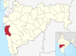
| map_caption = 在马哈拉施特拉邦的位置 |
|||
| coordinates = |
|||
| coor_pinpoint = 县府阿利巴格 |
|||
| subdivision_type = 国家 |
|||
| subdivision_name = {{flag|India}} |
|||
| subdivision_type1 = [[印度的邦和中央直辖区|邦]] |
|||
| subdivision_name1 = [[马哈拉施特拉邦]] |
|||
| subdivision_type2 = 专区 |
|||
| subdivision_name2 = {{link-en|康坎专区|Konkan division}} |
|||
| established_title = Established |
|||
| established_date = |
|||
| seat_type = 首府 |
|||
| seat = [[阿利巴格]] |
|||
| parts_type = |
|||
| parts_style = |
|||
| p1 = |
|||
| area_total_km2 = 7152 |
|||
| area_footnotes = |
|||
| population_as_of = 2011 |
|||
| population_total = 2,634,200 |
|||
| population_footnotes = |
|||
| population_urban = 36.91% |
|||
| population_density_km2 = auto |
|||
| demographics_type1 = 人口情况 |
|||
| demographics1_title1 = 识字率 |
|||
| demographics1_info1 = 83.14 |
|||
| demographics1_title2 = 性别比 |
|||
| demographics1_info2 = 1000:959(男:女) |
|||
| timezone1 = [[Indian Standard Time|IST]] |
|||
| utc_offset1 = +05:30 |
|||
| registration_plate = |
|||
| blank_name_sec2 = 年降雨量 |
|||
| blank_info_sec2 = 3884毫米 |
|||
| website = {{URL|https://raigad.gov.in/en/}} |
|||
| official_name = |
|||
}} |
|||
| ⚫ | |||
==人口== |
|||
{{historical populations|11=1901|12=7,21,083|13=1911|14=7,14,371|15=1921|16=6,77,586|17=1931|18=7,56,315|19=1941|20=8,05,157|21=1951|22=9,09,083|23=1961|24=10,58,855|25=1971|26=12,63,003|27=1981|28=14,86,452|29=1991|30=18,24,816|31=2001|32=22,07,929|33=2011|34=26,34,200|percentages=pagr|footnote=来源:<ref>[http://www.censusindia.gov.in/2011census/PCA/A2_Data_Table.html Decadal Variation In Population Since 1901]</ref>|align=right}} |
|||
2011年人口普查显示,该县总人口共2,634,200人,<ref name=districtcensus>{{cite web | url = http://www.census2011.co.in/district.php | title = District Census 2011 | access-date = 2011-09-30 | year = 2011 | publisher = Census2011.co.in}}</ref>几与[[科威特]]<ref name="cia">{{cite web | author = US Directorate of Intelligence | title = Country Comparison:Population | url = https://www.cia.gov/library/publications/the-world-factbook/rankorder/2119rank.html | archive-url = https://web.archive.org/web/20070613004507/https://www.cia.gov/library/publications/the-world-factbook/rankorder/2119rank.html | url-status = dead | archive-date = 13 June 2007 | access-date = 2011-10-01 | quote = Kuwait 2,595,62}}</ref>或美国[[内华达州]]相当。<ref>{{cite web|url=http://2010.census.gov/2010census/data/apportionment-pop-text.php |title=2010 Resident Population Data |publisher=U. S. Census Bureau |access-date=2011-09-30 |quote=Nevada 2,700,551 |url-status=dead |archive-url=https://web.archive.org/web/20131019160532/http://2010.census.gov/2010census/data/apportionment-pop-text.php |archive-date=2013-10-19 }}</ref>在全印640个县中排名153位。<ref name=districtcensus/>全县人口密度为{{convert| 368 |PD/sqkm|PD/sqmi}}。<ref name=districtcensus/>2001-2011年间人口增长率为19.31%。<ref name=districtcensus/>该县人口男女比例为1000:959,<ref name=districtcensus/>识字率为83.14%。<ref name=districtcensus/> |
|||
{{bar box |
|||
|title=赖加德县宗教信仰情况(2011年)<ref name="Religion">{{cite web |title=C-16 Population By Religion - Maharashtra|url=https://censusindia.gov.in/2011census/C-01/DDW27C-01%20MDDS.XLS |website=census.gov.in}}</ref> |
|||
|titlebar=#FCD116 |
|||
|left1=宗教 |
|||
|right1=比例 |
|||
|float=left |
|||
|bars= |
|||
{{bar percent|[[印度教]]|darkorange|85.01}} |
|||
{{bar percent|[[伊斯兰教]]|green|8.64}} |
|||
{{bar percent|[[佛教]]|mediumblue|4.62}} |
|||
{{bar percent|[[基督教]]|dodgerblue|0.66}} |
|||
{{bar percent|其他|black|1.07}} |
|||
}} |
|||
{{Pie chart |
|||
|thumb = right |
|||
|caption = 赖加德县语言使用情况(2011年)<ref name="Language">{{cite web |title=Table C-16 Population by Mother Tongue: Maharashtra |url=https://censusindia.gov.in/2011census/C-16/DDW-C16-STMT-MDDS-2700.XLSX|website=censusindia.gov.in|publisher=[[Registrar General and Census Commissioner of India]]}}</ref> |
|||
|label1 = [[马拉提语]] |value1 = 79.04 |color1 = red |
|||
|label2 = [[印地语]] |value2 = 7.06 |color2 = orange |
|||
|label3 = [[乌尔都语]] |value3 = 5.85 |color3 = green |
|||
|label4 = [[孔卡尼语]] |value4 = 4.01 |color4 = salmon |
|||
|label5 = 其他 |value5 = 4.04 |color5 = grey |
|||
}} |
|||
==参考资料== |
|||
{{reflist}} |
|||
==外部連結== |
==外部連結== |
||
2022年8月7日 (日) 16:22的版本
| 赖加德县 रायगड जिल्हा | |
|---|---|
| 马哈拉施特拉邦的县 | |
 在马哈拉施特拉邦的位置 | |
| 坐标:18°39′N 72°53′E / 18.65°N 72.88°E | |
| 国家 | |
| 邦 | 马哈拉施特拉邦 |
| 专区 | 康坎专区 |
| 首府 | 阿利巴格 |
| 面积 | |
| • Total | 7,152 平方公里(2,761 平方英里) |
| 人口(2011) | |
| • Total | 2,634,200人 |
| • 密度 | 368人/平方公里(954人/平方英里) |
| • 市区 | 36.91% |
| 人口情况 | |
| • 识字率 | 83.14 |
| • 性别比 | 1000:959(男:女) |
| 时区 | IST(UTC+05:30) |
| 年降雨量 | 3884毫米 |
| 網站 | raigad |
賴加德縣(印地語:रायगढ़ ज़िला,馬拉提語:रायगड जिल्हा)是印度的一個縣,位於該國西部,由馬哈拉施特拉邦負責管轄,面積7,149平方公里,識字率為83.89%,2011年人口2,635,394,人口密度每平方公里369人。县府设在阿利巴格。该县得名自马拉塔王国初期的首都赖加德城堡,位于该县境内。
人口
| 年份 | 人口 | ±% p.a. |
|---|---|---|
| 1901 | 721,083 | — |
| 1911 | 714,371 | −0.09% |
| 1921 | 677,586 | −0.53% |
| 1931 | 756,315 | +1.11% |
| 1941 | 805,157 | +0.63% |
| 1951 | 909,083 | +1.22% |
| 1961 | 1,058,855 | +1.54% |
| 1971 | 1,263,003 | +1.78% |
| 1981 | 1,486,452 | +1.64% |
| 1991 | 1,824,816 | +2.07% |
| 2001 | 2,207,929 | +1.92% |
| 2011 | 2,634,200 | +1.78% |
| 来源:[1] | ||
2011年人口普查显示,该县总人口共2,634,200人,[2]几与科威特[3]或美国内华达州相当。[4]在全印640个县中排名153位。[2]全县人口密度为368名居民每平方公里(950名居民每平方英里)。[2]2001-2011年间人口增长率为19.31%。[2]该县人口男女比例为1000:959,[2]识字率为83.14%。[2]
参考资料
- ^ Decadal Variation In Population Since 1901
- ^ 2.0 2.1 2.2 2.3 2.4 2.5 District Census 2011. Census2011.co.in. 2011 [2011-09-30].
- ^ US Directorate of Intelligence. Country Comparison:Population. [2011-10-01]. (原始内容存档于13 June 2007).
Kuwait 2,595,62
- ^ 2010 Resident Population Data. U. S. Census Bureau. [2011-09-30]. (原始内容存档于2013-10-19).
Nevada 2,700,551
- ^ C-16 Population By Religion - Maharashtra. census.gov.in.
- ^ Table C-16 Population by Mother Tongue: Maharashtra. censusindia.gov.in. Registrar General and Census Commissioner of India.
外部連結
18°39′00″N 72°52′48″E / 18.65000°N 72.88000°E
| 这是一篇有关印度行政区划的小作品。您可以通过编辑或修订扩充其内容。 |


