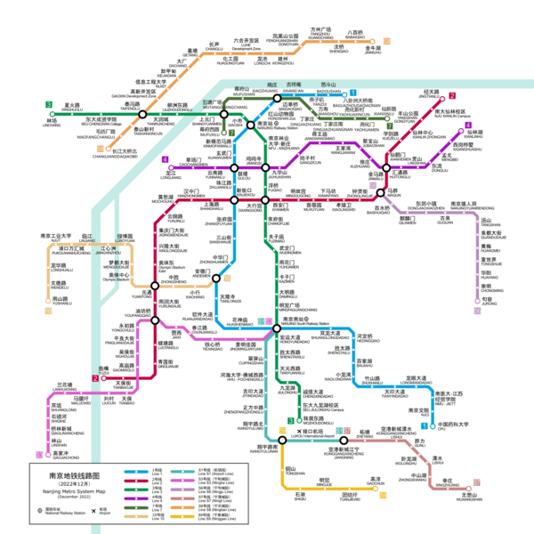
File:Nanjing Metro map.png
外观

本预览的尺寸:600 × 600像素。 其他分辨率:240 × 240像素 | 480 × 480像素 | 768 × 768像素 | 1,024 × 1,024像素 | 2,048 × 2,048像素 | 6,969 × 6,969像素。
原始文件 (6,969 × 6,969像素,文件大小:3.32 MB,MIME类型:image/png)
文件历史
点击某个日期/时间查看对应时刻的文件。
| 日期/时间 | 缩略图 | 大小 | 用户 | 备注 | |
|---|---|---|---|---|---|
| 2017年12月30日 (六) 05:05 |  | 6,975 × 6,675(2.79 MB) | Haha169 | Line S9 | |
| 2017年12月5日 (二) 16:17 |  | 6,960 × 6,960(2.97 MB) | Haha169 | Line S3 has opened | |
| 2017年2月10日 (五) 16:12 |  | 6,933 × 6,933(3.04 MB) | SSYoung | (Another) station name fixed | |
| 2017年2月10日 (五) 15:22 |  | 6,933 × 6,933(3.03 MB) | SSYoung | Station name fixed | |
| 2017年1月19日 (四) 03:58 |  | 6,933 × 6,933(3.03 MB) | Haha169 | fix situation where you have line 4 sticking off the map at the right | |
| 2017年1月19日 (四) 03:50 |  | 6,933 × 6,933(3.03 MB) | Haha169 | Line 4 Phase I has opened | |
| 2016年1月25日 (一) 10:57 |  | 6,933 × 6,933(2.35 MB) | Leiem | Update the English names of some stations | |
| 2015年6月12日 (五) 17:03 |  | 6,933 × 6,933(2.47 MB) | SSYoung | station name fixed | |
| 2015年4月5日 (日) 06:47 |  | 6,933 × 6,933(2.46 MB) | SSYoung | map legend | |
| 2015年4月4日 (六) 15:59 |  | 6,933 × 6,933(2.21 MB) | SSYoung | User created page with UploadWizard |
文件用途
以下6个页面使用本文件:
全域文件用途
以下其他wiki使用此文件:
- cs.wikipedia.org上的用途
- eo.wikipedia.org上的用途
- es.wikipedia.org上的用途
- eu.wikipedia.org上的用途
- fi.wikipedia.org上的用途
- id.wikipedia.org上的用途
- ja.wikipedia.org上的用途
- ka.wikipedia.org上的用途
- nl.wikipedia.org上的用途
- pnb.wikipedia.org上的用途
- sv.wikipedia.org上的用途
- th.wikipedia.org上的用途
- รถไฟใต้ดินหนานจิง
- แม่แบบ:รถไฟใต้ดินหนานจิง
- รถไฟใต้ดินหนานจิง สาย 1
- รถไฟใต้ดินหนานจิง สาย 2
- รถไฟใต้ดินหนานจิง สาย 3
- รถไฟใต้ดินหนานจิง สาย S1
- รถไฟใต้ดินหนานจิง สาย S7
- รถไฟใต้ดินหนานจิง สาย 4
- รถไฟใต้ดินหนานจิง สาย S9
- รถไฟใต้ดินหนานจิง สาย 10
- รถไฟใต้ดินหนานจิง สาย S3
- รถไฟใต้ดินหนานจิง สาย S8
- รถไฟใต้ดินหนานจิง สาย S6
- รถไฟใต้ดินหนานจิง สาย 7
- รถไฟใต้ดินหนานจิง สาย S5
- tr.wikipedia.org上的用途
- uk.wikipedia.org上的用途
- ur.wikipedia.org上的用途
- uz.wikipedia.org上的用途


