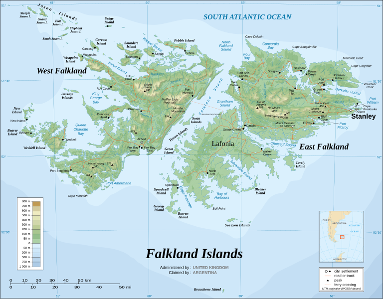
File:Falkland Islands topographic map-en.svg
外觀

此 SVG 檔案的 PNG 預覽的大小:768 × 599 像素。 其他解析度:308 × 240 像素 | 615 × 480 像素 | 984 × 768 像素 | 1,280 × 999 像素 | 2,560 × 1,998 像素 | 2,550 × 1,990 像素。
原始檔案 (SVG 檔案,表面大小:2,550 × 1,990 像素,檔案大小:1.97 MB)
檔案歷史
點選日期/時間以檢視該時間的檔案版本。
| 日期/時間 | 縮圖 | 尺寸 | 用戶 | 備註 | |
|---|---|---|---|---|---|
| 2007年6月16日 (六) 00:20 |  | 2,550 × 1,990(1.03 MB) | Sting | Trying to fix the bug on WP-en #5 | |
| 2007年6月16日 (六) 00:18 |  | 2,550 × 1,990(2 MB) | Sting | Trying to fix the bug on WP-en #4 | |
| 2007年6月16日 (六) 00:09 |  | 2,550 × 1,990(2 MB) | Sting | Trying to fix the bug on WP-en #3 | |
| 2007年6月15日 (五) 23:59 |  | 2,550 × 1,990(2.03 MB) | Sting | Trying to fix the bug on WP-en #2 | |
| 2007年6月15日 (五) 23:22 |  | 2,550 × 1,990(2 MB) | Sting | Trying to fix the bug on WP-en | |
| 2007年5月5日 (六) 01:46 |  | 2,550 × 1,990(2.03 MB) | Sting | "Grantham Sound" : forgotten translation | |
| 2007年5月2日 (三) 15:10 |  | 2,550 × 1,990(2.03 MB) | Sting | Taking out old demographic data | |
| 2007年4月5日 (四) 18:37 |  | 2,550 × 1,990(2.03 MB) | Sting | Enhanced shaded relief | |
| 2007年4月5日 (四) 04:54 |  | 2,550 × 1,990(1.85 MB) | Sting | ||
| 2007年4月5日 (四) 04:29 |  | 2,550 × 1,990(1.86 MB) | Sting | Again |
檔案用途
下列3個頁面有用到此檔案:
全域檔案使用狀況
以下其他 wiki 使用了這個檔案:
- af.wikipedia.org 的使用狀況
- ar.wikipedia.org 的使用狀況
- ast.wikipedia.org 的使用狀況
- azb.wikipedia.org 的使用狀況
- bcl.wikipedia.org 的使用狀況
- bg.wikipedia.org 的使用狀況
- bn.wikipedia.org 的使用狀況
- ca.wikipedia.org 的使用狀況
- ckb.wikipedia.org 的使用狀況
- crh.wikipedia.org 的使用狀況
- cs.wikipedia.org 的使用狀況
- cv.wikipedia.org 的使用狀況
- de.wikipedia.org 的使用狀況
- en.wikipedia.org 的使用狀況
- Geography of the Falkland Islands
- Irredentism
- West Falkland
- Lafonia
- List of settlements in the Falkland Islands
- Category talk:Geography
- List of Scottish place names in other countries
- Falkland Islands sovereignty dispute
- Wikipedia:WikiProject Argentina
- Geology of the Falkland Islands
- Portal:Geography/Featured picture archive
- Wikipedia:Featured pictures thumbs/06
- Portal:Maps/Selected picture
- Falkland Islands
- List of Falkland Islands placenames
- Port Albemarle
- King George Bay
- Byron Sound
- MacBride Head
- Keppel Sound
- History of the Special Air Service
- Wikipedia:Featured picture candidates/Falkland Islands topographic map-en.svg
- List of rivers of the Falkland Islands
- Port William, Falkland Islands
- Bay of Harbours
- Adventure Sound
- Queen Charlotte Bay
- Foul Bay, Falkland Islands
- Concordia Bay
- Eagle Passage
檢視此檔案的更多全域使用狀況。


