強烈颱風海棠 (2005年)
| 強烈颱風海棠 Typhoon Haitang(英文) | |||||||||||||
|---|---|---|---|---|---|---|---|---|---|---|---|---|---|
 強烈颱風海棠 | |||||||||||||
| |||||||||||||
| |||||||||||||
| |||||||||||||
| |||||||||||||
| 概況 | |||||||||||||
| 形成日期 | 2005年7月11日 | ||||||||||||
| 消散日期 | 2005年7月20日 | ||||||||||||
| 最低氣壓 | 912 hPa | ||||||||||||
| 瞬間最大陣風 | 280 km/h | ||||||||||||
| 影響 | |||||||||||||
| 財產損失 | |||||||||||||
| 死傷人數 | |||||||||||||
| 影響地區 | |||||||||||||
| 2005年太平洋颱風季的一部分 | |||||||||||||
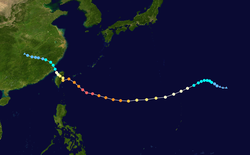
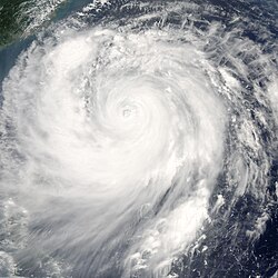
強烈颱風海棠(英語:Typhoon Haitang,國際編號:0505,聯合颱風警報中心:05W,菲律賓大氣地球物理和天文管理局:Feria)為2005年太平洋颱風季第五個被命名的風暴。「海棠」一名由中國提供,指的就是「海棠」這種植物。
海棠也是2005年太平洋颱風季第一個登陸台灣及中國大陸的颱風;其與同年稍後的颱風泰利及颱風龍王2個強烈颱風(台灣中央氣象局分級)接連侵襲並登陸台灣,使2005年繼1994年後,台灣第一次於同年對2個以上的強烈颱風發布陸上颱風警報;這也是繼1965年後,第一次有3個強烈颱風於同年登陸台灣。
簡介
在北太平洋西部生成的颱風,多會受到副熱帶高壓脊所影響。自2005年7月初開始,日本南方持續有高氣壓滯留,是導引強烈颱風海棠向西行進的主要原因之一。
7月16日,中華民國行政院國家科學委員會的追風計畫執行單位,研究人員搭乘飛機於強烈颱風海棠周圍台灣東方1,000公里高空,投出14個衛星定位的投落送(大氣偵測探空儀),以利全球氣象單位分析颱風結構與行進方向。
7月17日下午,首先進入暴風圈的陸地是日本石垣島,台灣全島於17日晚間陸續進入暴風圈的範圍。
海棠7月18日上午移動到台灣花蓮東方約60公里的位置,其氣流使於位背風面的臺東地區出現了溫度高而濕度低的焚風效應,清晨溫度達37.4℃,位於台東的成功氣象站於台灣6點30分,測得的溫度為38.1℃,濕度只有約40%。
根據資料顯示,海棠在花蓮縣沿海逆時針打轉一圈後,於18日14時50分自宜蘭縣蘇澳鎮東澳溪附近登陸,22時左右自苗栗縣後龍鎮出海。19日17時10分,海棠在福建省福州市連江縣筱埕鎮登陸,暴風圈逐漸縮小。海棠於7月20日早上在福建省寧德市周寧縣禮門鄉境內減弱為熱帶風暴。
由於珠江三角洲處於強烈颱風海棠外圍,因此受到下沉氣流的影響,加劇了廣東與香港的酷熱天氣。在香港,7月18日及7月19日都測得34℃-37℃的氣溫,其中香港天文台在7月19日測得35.4℃,是1990年8月18日香港測得歷史高溫36.1℃以來的最高氣溫。而澳門在7月19日更測得39.0℃的氣溫,是澳門氣象局自1901年有紀錄以來的最高溫度。在7月17日、7月20日及7月21日,因熱成雨影響,珠三角多次受局部地區性雷暴影響,下起大驟雨和雷暴,引致7月20日香港部分地區出現停電,九廣西鐵出現信號系統故障。7月20日及21日香港均有冰雹報告。
影響
- 台灣國內線班機18日全面停飛,國際線班機亦大部分停飛。
- 因南部蔬菜產地受損嚴重,致使葉菜類價格狂飆,青蔥1公斤更漲到超過新台幣400元,法務部下令各地檢察官介入調查有無哄抬價格情事。
- 第十一屆台北國際電信展因為海棠颱風來襲的關係,原本的展期也提前於7月17日結束,創下台北世界貿易中心舉辦展覽以來,第一次因颱風而停止展覽的紀錄。
- 原訂7月20日至7月24日於福隆海水浴場舉辦的搖滾盛事-貢寮國際海洋音樂祭-亦受到海棠颱風的影響,無法如期舉辦,並決定延後日期至8月3日至8月7日舉行。
- 宜蘭縣太平山森林遊樂區因聯外道路坍方及園內設施受損,自20日起休園半個月。
- 原定7月21日下午實施的中部地區萬安二十八號演習,因南投縣、台中縣、嘉義縣需進行災後復原而另行擇期實施。
災害
| 臺灣颱風降雨紀錄 | ||||||
|---|---|---|---|---|---|---|
| 累計降雨紀錄 | 年份 | 風暴名稱 | 發生地點 | 附註 | ||
| 排行 | 公釐 | 英吋 | ||||
| 1 | 3,060 | 120.5 | 2009年 | 颱風莫拉克 | 嘉義縣阿里山鄉 | [1] |
| 2 | 2,319 | 91.3 | 2001年 | 颱風納莉 | 臺北縣烏來鄉 | [2] |
| 3 | 2,162 | 85.1 | 1969年 | 熱帶風暴芙勞西 | 臺北市北投區 | [1] |
| 4 | 1,987 | 78.2 | 1996年 | 颱風賀伯 | 嘉義縣阿里山鄉 | [3] |
| 5 | 1,914 | 75.4 | 2024年 | 颱風凱米 | 高雄市茂林區 | [4] |
| 6 | 1,834 | 72.2 | 1987年 | 颱風琳恩 | 臺北市北投區 | [5] |
| 7 | 1,774 | 69.8 | 2012年 | 颱風蘇拉 | 宜蘭縣宜蘭市 | [6] |
| 8 | 1,672 | 65.8 | 1967年 | 颱風解拉 | 宜蘭縣冬山鄉 | [7] |
| 9 | 1,611 | 63.4 | 2008年 | 颱風辛樂克 | 臺中縣和平鄉 | [8] |
| 10 | 1,561 | 61.5 | 2005年 | 颱風海棠 | 屏東縣三地門鄉 | [9] |
- 台灣鐵路管理局於17日晚間宣布18日的各級列車全面停駛,為台灣鐵路史上首次的全面停駛,估計損失達新台幣5,000萬元。19日除南迴線外,全線恢復正常行駛。
- 台灣東部18日出現的焚風現象,雖然只持續了2小時,但仍嚴重地影響到台東地區的農業生產,許多將屆收成的水果作物例如葡萄與釋迦,都因持續的乾燥熱風而脫水乾枯,造成當地果農損失慘重。
- 台灣西部彰化地區18日也受到颱風中心北方的東北風過山下沈而出現的焚風現象,有部分民眾因悶熱氣溫無法入睡,但有農民一大早到田間搶收蔬菜時,卻發現蔬菜遭焚風刮得枯萎,嚴重的有如被火燒過的痕跡。
- 由於7月18日適逢大潮再加上颱風所帶來的豪雨與強大西北風產生的大浪等影響,台灣西南部沿海低窪地區出現海水暴漲的情況,其中台南縣北門鄉甚至發生海水倒灌導致潰堤的情況。
- 台一線枋山鄉楓港大橋於19日被暴漲的楓港溪溪水沖毀,南迴公路、南迴鐵路坍方,恆春五里亭機場也因氣候不佳關閉,加上停水停電,恆春半島六鄉鎮20萬人及數千名遊客受困。待天氣好轉後,政府於20日緊急派遣救援專機前往恆春將旅客運送出去,並於晚間緊急將鋼管橋架設完成。
- 中部橫貫公路多處交通中斷,台中縣和平鄉、谷關、梨山、松鶴部落等地上千人受困。
- 高雄縣三民鄉(即今高雄市那瑪夏區)、茂林鄉、桃源鄉對外交通中斷。
- 台東縣金峰鄉太麻里溪溪水暴漲,將當地衛生所、教堂及16棟民宅沖毀。
- 國家二級古蹟下淡水溪鐵橋遭暴漲的高屏溪水沖毀。
- 林邊溪溪水暴漲沖毀堤防,屏東縣林邊鄉水深及膝。另外九如鄉、新園鄉、東港鎮、佳冬鄉、車城鄉亦傳出淹水災情。
- 因海棠颱風夾帶的旺盛西南氣流於19日晚間降下驚人豪雨,使台南縣麻豆鎮嚴重淹水,19日晚間緊急封閉國道一號麻豆交流道,國道一號新營-麻豆路段也因積水於20日早上7時雙向封閉。另外七股鄉、佳里鎮、學甲鎮、北門鄉、官田鄉、善化鎮、安定鄉、西港鄉、仁德鄉等鄉鎮都出現豪雨淹水災情。
- 嘉義縣朴子市、東石鄉、布袋鎮、臺南市南區、安南區、高雄縣岡山鎮、美濃鎮、阿蓮鄉、梓官鄉、永安鄉及湖內鄉因19日一夜豪雨而傳出淹水災情,其中美濃鎮自18日起3天內已淹水5次。
- 石門水庫原水濁度暴增,加上石門後池堰抽水站滲水故障,桃園縣中壢市、八德市、平鎮市及龍潭鄉等地約有10萬戶因而停水。
- 砂石船永昌輪於18日在高雄縣永安鄉外海擱淺,船上21人中19人獲救,1人死亡,1人落海失蹤。
- 高雄市區超過3000棵路樹傾倒。
各地最強陣風
台灣各地最強陣風主要發生在18日。
休假
- 18日除金門縣、連江縣(馬祖)外,台灣各縣市皆停止上班上課一天,台北股市亦休市。
- 19日澎湖縣、金門縣、連江縣(馬祖)、苗栗縣泰安鄉、台中縣和平鄉、台東縣成功鎮、長濱鄉、金峰鄉、大武鄉、達仁鄉、蘭嶼鄉、綠島鄉、東河鄉停止上班上課。
- 19日苗栗縣以南及台東縣,除前述鄉鎮停止上班上課,均照常上班。台中市及彰化縣正常上班上課外,高中職以下停止上課。
- 20日台南縣照常上班,高中職以下停止上課。
- 日本政府於7月17日下午宣布琉球石垣島、宮古島與日本國內班機船隻航班全部暫停起降航行。
- 浙江省氣象局17日15時發布「颱風緊急警報」,浙江各地緊急啟動「防颱抗颱應急預案」。
災害
形成歷程
 Module:Location_map第405行Lua錯誤:A hemisphere can only be provided with DMS degrees for longitudeModule:Location_map第405行Lua錯誤:A hemisphere can only be provided with DMS degrees for longitudeModule:Location_map第405行Lua錯誤:A hemisphere can only be provided with DMS degrees for longitudeModule:Location_map第405行Lua錯誤:A hemisphere can only be provided with DMS degrees for longitudeModule:Location_map第405行Lua錯誤:A hemisphere can only be provided with DMS degrees for longitudeModule:Location_map第405行Lua錯誤:A hemisphere can only be provided with DMS degrees for longitudeModule:Location_map第405行Lua錯誤:A hemisphere can only be provided with DMS degrees for longitudeModule:Location_map第405行Lua錯誤:A hemisphere can only be provided with DMS degrees for longitudeModule:Location_map第405行Lua錯誤:A hemisphere can only be provided with DMS degrees for longitudeModule:Location_map第405行Lua錯誤:A hemisphere can only be provided with DMS degrees for longitudeModule:Location_map第405行Lua錯誤:A hemisphere can only be provided with DMS degrees for longitudeModule:Location_map第405行Lua錯誤:A hemisphere can only be provided with DMS degrees for longitudeModule:Location_map第405行Lua錯誤:A hemisphere can only be provided with DMS degrees for longitudeModule:Location_map第405行Lua錯誤:A hemisphere can only be provided with DMS degrees for longitudeModule:Location_map第405行Lua錯誤:A hemisphere can only be provided with DMS degrees for longitudeModule:Location_map第405行Lua錯誤:A hemisphere can only be provided with DMS degrees for longitudeModule:Location_map第405行Lua錯誤:A hemisphere can only be provided with DMS degrees for longitudeModule:Location_map第405行Lua錯誤:A hemisphere can only be provided with DMS degrees for longitudeModule:Location_map第405行Lua錯誤:A hemisphere can only be provided with DMS degrees for longitudeModule:Location_map第405行Lua錯誤:A hemisphere can only be provided with DMS degrees for longitudeModule:Location_map第405行Lua錯誤:A hemisphere can only be provided with DMS degrees for longitudeModule:Location_map第405行Lua錯誤:A hemisphere can only be provided with DMS degrees for longitudeModule:Location_map第405行Lua錯誤:A hemisphere can only be provided with DMS degrees for longitudeModule:Location_map第405行Lua錯誤:A hemisphere can only be provided with DMS degrees for longitudeModule:Location_map第405行Lua錯誤:A hemisphere can only be provided with DMS degrees for longitudeModule:Location_map第405行Lua錯誤:A hemisphere can only be provided with DMS degrees for longitudeModule:Location_map第405行Lua錯誤:A hemisphere can only be provided with DMS degrees for longitudeModule:Location_map第405行Lua錯誤:A hemisphere can only be provided with DMS degrees for longitudeModule:Location_map第405行Lua錯誤:A hemisphere can only be provided with DMS degrees for longitudeModule:Location_map第405行Lua錯誤:A hemisphere can only be provided with DMS degrees for longitudeModule:Location_map第405行Lua錯誤:A hemisphere can only be provided with DMS degrees for longitudeModule:Location_map第405行Lua錯誤:A hemisphere can only be provided with DMS degrees for longitudeModule:Location_map第405行Lua錯誤:A hemisphere can only be provided with DMS degrees for longitudeModule:Location_map第405行Lua錯誤:A hemisphere can only be provided with DMS degrees for longitudeModule:Location_map第405行Lua錯誤:A hemisphere can only be provided with DMS degrees for longitudeModule:Location_map第405行Lua錯誤:A hemisphere can only be provided with DMS degrees for longitudeModule:Location_map第405行Lua錯誤:A hemisphere can only be provided with DMS degrees for longitudeModule:Location_map第405行Lua錯誤:A hemisphere can only be provided with DMS degrees for longitudeModule:Location_map第405行Lua錯誤:A hemisphere can only be provided with DMS degrees for longitudeModule:Location_map第405行Lua錯誤:A hemisphere can only be provided with DMS degrees for longitudeModule:Location_map第405行Lua錯誤:A hemisphere can only be provided with DMS degrees for longitudeModule:Location_map第405行Lua錯誤:A hemisphere can only be provided with DMS degrees for longitudeModule:Location_map第405行Lua錯誤:A hemisphere can only be provided with DMS degrees for longitudeModule:Location_map第405行Lua錯誤:A hemisphere can only be provided with DMS degrees for longitudeModule:Location_map第405行Lua錯誤:A hemisphere can only be provided with DMS degrees for longitude
| 時間 | 中心位置 | 中心氣壓 | 移動速度 | 近中心風力 | 瞬間風速 | 備註 |
| 7月11日8時 | 熱帶性低氣壓 | |||||
| 7月12日8時 | 北緯23.2度,東經151.8度 | 1002百帕 | 時速11公里,向西移動 | 每秒16公尺 | 每秒25公尺 | 輕度颱風形成 |
| 7月13日8時 | 北緯22.9度,東經149.2度 | 998百帕 | 時速20公里,向西南西移動 | 每秒20公尺 | 每秒28公尺 | |
| 7月14日8時 | 北緯20度,東經144.6度 | 970百帕 | 時速31公里,向西南西轉西移動 | 每秒33公尺 | 每秒43公尺 | 轉為中度颱風 |
| 7月15日8時 | 北緯19.2度,東經136.8度 | 960百帕 | 時速30公里,向西移動 | 每秒38公尺 | 每秒48公尺 | |
| 7月15日14時 | 北緯19.1度,東經134.8度 | 955百帕 | 時速27公里,向西轉西北西 | 每秒40公尺 | 每秒50公尺 | |
| 7月16日8時 | 北緯19.8度,東經130.3度 | 940百帕 | 時速26轉22公里, 向西北西 | 每秒45公尺 | 每秒55公尺 | |
| 7月16日14時30分 | 北緯20.3度,東經129.0度 | 925百帕 | 時速24轉19公里,向西北西 | 每秒51公尺 | 每秒63公尺 | 轉為強烈颱風 |
| 7月17日9時 | 北緯21.6度,東經125.6度 | 912百帕 | 時速17公里,西北西轉西北 | 每秒55公尺 | 每秒68公尺 | |
| 7月17日20時 | 北緯23.0度,東經123.9度 | 920百帕 | 時速20公里,西北西 | 每秒53公尺 | 每秒65公尺 | |
| 7月18日1時 | 北緯23.6度,東經123.1度 | 925百帕 | 時速17轉12公里,西北 | 每秒51公尺 | 每秒63公尺 | 暴風直徑560km |
| 7月18日5時 | 北緯23.6度,東經123.1度 | 925百帕 | 時速17轉12公里速度,向西北西 | 每秒51公尺 | 每秒63公尺 | 颱風眼減小 |
| 7月18日10時 | 北緯24.0度,東經122.2度 | 925百帕 | 時速15轉12公里,西北西 | 每秒51公尺 | 每秒63公尺 | |
| 7月18日11時 | 北緯23.5度,東經121.9度 | 925百帕 | 時速15轉11公里,西北西 | 每秒51公尺 | 每秒63公尺 | |
| 7月18日12時 | 北緯23.7度,東經122.0度 | 925百帕 | 時速15轉11公里,西北西 | 每秒51公尺 | 每秒63公尺 | |
| 7月18日13時 | 北緯23.9度,東經122.0度 | 925百帕 | 時速15轉11公里,西北西 | 每秒51公尺 | 每秒63公尺 | |
| 7月18日14時 | 北緯24.2度,東經121.9度 | 925百帕 | 時速14轉11公里,西北西 | 每秒51公尺 | 每秒63公尺 | |
| 7月18日15時 | 北緯24.6度,東經121.8度 | 925百帕 | 時速14轉11公里,西北西 | 每秒51公尺 | 每秒63公尺 | 自宜蘭東澳登陸 |
| 7月18日16時 | 北緯24.6度,東經121.6度 | 925百帕 | 時速14轉11公里,西北西 | 每秒51公尺 | 每秒63公尺 | |
| 7月18日17時 | 北緯24.6度,東經121.5度 | 940百帕 | 時速14轉11公里,西北西 | 每秒45公尺 | 每秒55公尺 | 減弱為中度颱風 |
| 7月18日18時 | 北緯24.6度,東經121.4度 | 940百帕 | 時速14轉11公里,西北西 | 每秒45公尺 | 每秒55公尺 | |
| 7月18日19時 | 北緯24.6度,東經121.2度 | 940百帕 | 時速14轉11公里,西北西 | 每秒45公尺 | 每秒55公尺 | |
| 7月18日20時 | 北緯24.5度,東經120.9度 | 955百帕 | 時速14轉11公里,西北西 | 每秒40公尺 | 每秒50公尺 | |
| 7月18日21時 | 北緯24.5度,東經120.8度 | 955百帕 | 時速14轉11公里,西北西 | 每秒40公尺 | 每秒50公尺 | |
| 7月18日22時 | 北緯24.6度,東經120.7度 | 955百帕 | 時速14轉11公里,西北西 | 每秒40公尺 | 每秒50公尺 | 自苗栗縣後龍出海 |
| 7月18日23時 | 北緯24.6度,東經120.5度 | 955百帕 | 時速14轉11公里,西北西 | 每秒40公尺 | 每秒50公尺 | |
| 7月19日0時 | 北緯24.6度,東經120.4度 | 955百帕 | 時速14轉11公里,西北西 | 每秒40公尺 | 每秒50公尺 | |
| 7月19日1時 | 北緯24.6度,東經120.4度 | 955百帕 | 時速14轉11公里,西北西 | 每秒40公尺 | 每秒50公尺 | |
| 7月19日2時 | 北緯24.6度,東經120.3度 | 955百帕 | 時速14轉11公里,西北西 | 每秒40公尺 | 每秒50公尺 | |
| 7月19日10時 | 北緯25.3度,東經120.1度 | 965百帕 | 時速11公里,西北 | 每秒35公尺 | 每秒45公尺 | |
| 7月19日11時 | 北緯25.4度,東經120.0度 | 970百帕 | 時速11公里,西北 | 每秒33公尺 | 每秒43公尺 | |
| 7月19日12時 | 北緯25.5度,東經120.0度 | 970百帕 | 時速11公里,西北 | 每秒33公尺 | 每秒43公尺 | |
| 7月19日13時 | 北緯25.6度,東經119.9度 | 970百帕 | 時速11公里,西北 | 每秒33公尺 | 每秒43公尺 | |
| 7月19日14時 | 北緯25.7度,東經119.8度 | 975百帕 | 時速11公里,西北 | 每秒30公尺 | 每秒38公尺 | 減弱為輕度颱風 |
| 7月19日15時 | 北緯25.8度,東經119.8度 | 975百帕 | 時速11公里,西北 | 每秒30公尺 | 每秒38公尺 | |
| 7月19日16時 | 北緯25.9度,東經119.8度 | 975百帕 | 時速11公里,西北 | 每秒30公尺 | 每秒38公尺 | |
| 7月19日17時 | 北緯26.1度,東經119.8度 | 975百帕 | 時速11公里,西北 | 每秒30公尺 | 每秒38公尺 | |
| 7月19日18時 | 北緯26.3度,東經119.7度 | 975百帕 | 時速11公里,西北 | 每秒30公尺 | 每秒38公尺 | 登陸中國福建 |
| 7月19日19時 | 北緯26.4度,東經119.6度 | 975百帕 | 時速11公里,西北 | 每秒30公尺 | 每秒38公尺 | |
| 7月19日20時 | 北緯26.6度,東經119.5度 | 975百帕 | 時速11公里,西北 | 每秒30公尺 | 每秒38公尺 | |
| 7月19日21時 | 北緯26.7度,東經119.4度 | 975百帕 | 時速11公里,西北 | 每秒30公尺 | 每秒38公尺 | 暴風圈縮小 |
| 7月19日22時 | 北緯26.7度,東經119.3度 | 975百帕 | 時速11公里,西北 | 每秒30公尺 | 每秒38公尺 | |
| 7月19日23時 | 北緯26.8度,東經119.3度 | 985百帕 | 時速11公里,西北 | 每秒25公尺 | 每秒33公尺 | |
| 7月20日0時 | 北緯26.9度,東經119.2度 | 985百帕 | 時速11公里,西北 | 每秒25公尺 | 每秒33公尺 | |
| 7月20日1時 | 北緯27.0度,東經119.0度 | 985百帕 | 時速11公里,西北 | 每秒25公尺 | 每秒33公尺 | 暴風圈縮小 |
| 7月20日2時 | 北緯27.1度,東經118.9度 | 990百帕 | 時速13公里,西北 | 每秒20公尺 | 每秒28公尺 | 台灣解除颱風警報 |
| 7月20日3時 | 北緯27.2度,東經118.8度 |
圖片庫
-
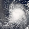
7月14日
-
7月15日
-
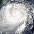
7月17日
-
7月17日
-
7月17日
-
7月18日
-
7月20日
參考資料
- ^ 1.0 1.1 侵臺颱風資料庫. 交通部中央氣象局. 2010年 [2011-10-19].
- ^ 莫拉克颱風暴雨量及洪流量分析 (PDF). 經濟部水利署. 2009-09-09 [2011-07-17].
- ^ 莫拉克颱風暴雨量及洪流量分析 (PDF). 經濟部水利署. 2009-09-09 [2011-07-17].
- ^ 凱米剛走!南部、東部有雨 又有熱帶擾動生成「靠近台灣時間曝光」, 台視新聞, 2024/07/27
- ^ 李清勝、羅英哲、張龍耀. 琳恩颱風(1987)與東北季風交互作用產生強降水之研究 (PDF) (報告). 國立臺灣大學大氣科學研究所. 2007 [November 7, 2015].
- ^ Typhoon Saola dumps heavy downpours around Taiwan. Chen Zhi. 新華社. 2012-08-02 [2012-08-02].
- ^ Topic 2.1 Observing and forecasting rainfall. Fifth International Workshop on Tropical Cyclones. Lianshou, Chen. [August 4, 2012].
- ^ 辛樂克颱風應變災情第12報 (PDF). 中央災害應變中心. 2008-09-16 [2009-01-13].
- ^ Haitang fizzles out, leaves Taiwan wet. Chiu Yu-Tzu. 臺北時報. 2005-07-20 [2010-04-11].
參見
外部連結
- (日語)http://www.jma.go.jp/ 日本氣象廳首頁
- (英文)http://www.usno.navy.mil/JTWC/ 聯合颱風警報中心首頁
- (簡體中文)http://www.nmc.gov.cn/ 中央氣象台首頁
- (繁體中文)http://www.cwb.gov.tw/ 中央氣象局首頁
- (繁體中文)http://www.hko.gov.hk/ 香港天文台首頁
- (繁體中文)http://www.smg.gov.mo/ 澳門地球物理暨氣象局首頁

