切斯特頓 (馬里蘭州)
外观
| 切斯特頓 Chestertown, Maryland | |
|---|---|
| 鎮 | |
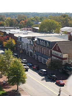
 切斯特敦的高街 | |
| 格言:「切斯特河上歷史悠久的殖民地鎮」[1] | |
 切斯特頓在馬里蘭州中的位置 | |
| 坐标:39°13′10″N 76°04′06″W / 39.2194°N 76.0683°W | |
| 國家 | 美國 |
| 州 | 馬里蘭州 |
| 縣 | 肯特縣 |
| 面积[2] | |
| • 总计 | 2.91 平方英里(7.54 平方公里) |
| • 陸地 | 2.60 平方英里(6.73 平方公里) |
| • 水域 | 0.31 平方英里(0.80 平方公里) |
| 海拔 | 20 英尺(6 公尺) |
| 人口(2010年)[3] | |
| • 總計 | 5,252人 |
| • 估计(2012[4]) | 5,368 |
| • 密度 | 2,020.0人/平方英里(779.9人/平方公里) |
| 时区 | 北美東部時區(UTC-5) |
| • 夏时制 | 北美東部時區(UTC-4) |
| ZIP代碼 | 21620 |
| 電話區號 | 410、443 |
| FIPS代碼 | 24-16225 |
| GNIS代碼 | 0589954 |
| 網站 | Chestertown, Maryland |
切斯特頓(英語:Chestertown)是美國馬里蘭州肯特縣的縣治。[5] 根據2010年人口普查,该城人口达5,252人。[6]
地理
切斯特頓的座標為39°13′10″N 76°4′6″W / 39.21944°N 76.06833°W。[9]根據2000年人口普查,本城面積為2.91平方英里(7.54平方公里),其中2.60平方英里(6.73平方公里)為陸地,0.31平方英里(0.80平方公里)為水域[2]。根據1790年人口普查,切斯特頓是美國的人口中心。[10][11]
參考文獻
- ^ Chestertown, Maryland. Chestertown, Maryland. [August 25, 2012].
- ^ 2.0 2.1 US Gazetteer files 2010. United States Census Bureau. [2013-01-25].
- ^ American FactFinder. United States Census Bureau. [2013-01-25].
- ^ Population Estimates. United States Census Bureau. [2013-06-26]. (原始内容存档于2013-06-17).
- ^ Find a County. National Association of Counties. [2011-06-07].
- ^ "2010 Census P.L. 94-171 Summary File Data". United States Census Bureau.
- ^ Chestertown, Maryland. City-Data.com. [August 24, 2012].
- ^ Profile for Chestertown, Maryland, MD. ePodunk. [August 24, 2012].
- ^ US Gazetteer files: 2010, 2000, and 1990. United States Census Bureau. 2011-02-12 [2011-04-23].
- ^ 2000 U.S. Population Centered in Phelps County, Mo., a U.S. Census Bureau press release
- ^ 2000 U.S. Population Centered in Phelps County, Mo., a U.S. Census Bureau press release
