春武里府
Template:Infobox Thailand province
春武里府(泰文:จังหวัดชลบุรี,英文:Chonburi Province)在泰國東部,她的西南面是泰國灣,北到東南面(順時針)分別是泰國的北柳府、尖竹汶府和羅勇府。
名稱由來
在印度梵文當中「Chon」的意思是「水」,而「Buri」的意思是「城市」,所以就是「水的城市」或「水都」。
地理
The province is located at the Bay of Bangkok, the northern end of the Gulf of Thailand. A mountain range stretches from the north-west to the south-east of the province, while the fertile plains of the north were long used for farming. In Laem Chabang in the south of the province is one of the few deep-water harbours of Thailand.
雜聞
Until the 1960s Pattaya was a small fishing village, but during the Vietnam war the American troops had a base nearby, and Pattaya became a popular R&R location. The city grew quickly and became the prime tourist location in Thailand.
The 20th World Scout Jamboree, put on by the World Organization of the Scout Movement, drew 30,000 teenaged Boy Scouts to a naval base near the village of Sattahip, where activities included world issue awareness, a showcase of Thai science & technology, obstacle course-style competitions between nations, and an epic game of "Ashes" Cricket (the Aussies won).
府徽和府花

|
The provincial seal shows the hill Khao Sam Muk, on which a holy joss-house is located. The local people believe that the spirit of that mountain protects the fishermen from harm.
Provincial tree as well as flower is the Burmese Rosewood (Pterocarpus indicus, local name Pradu). |
行政及管理

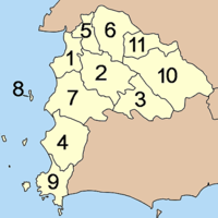
本府行政上被劃分為11個大區(ampoe),又進一步被劃分為92個社區(tambon)及691個村(muban)。
| 泰文 | 英文 | 中文 | 人口 | |
| 1 | อำเภอเมืองชลบุรี | Amphoe Mueang Phang Nga | 春武里府城 | 大約三萬八千人 |
| 2 | อำเภอบ้านบึง | Amphoe Ban Bueng | 暫無 | 不详 |
| 3 | อำเภอหนองใหญ่ | Amphoe Nong Yai | 暫無 | 不详 |
| 4 | อำเภอบางละมุง | Amphoe Bang Lamung | 暫無 | 不详 |
| 5 | อำเภอพานทอง | Amphoe Phan Thong | 暫無 | 不详 |
| 6 | อำเภอพนัสนิคม | Amphoe Phanat Nikhom | 暫無 | 不详 |
| 7 | อำเภอศรีราชา | Amphoe Si Racha | 是拉差區 | 不详 |
| 8 | อำเภอเกาะสีชัง | Amphoe Ko Sichang | 暫無 | 不详 |
| 9 | อำเภอสัตหีบ | Amphoe Sattahip | 暫無 | 不详 |
| 10 | อำเภอบ่อทอง | Amphoe Bo Thong | 暫無 | 不详 |
| 11 | อำเภอเกาะจันทร์ | Amphoe Ko Chan | 暫無 | 不详 |

