丹尼尔森陨击坑
外观
 显示了丹尼尔森撞击坑和附近其他的陨石坑的火星轨道器激光高度计测绘图。颜色表示海拔高度,丹尼尔森撞击坑位于右上方。 | |
| 行星 | 火星 |
|---|---|
| 区域 | 欧克西亚沼区 |
| 坐标[锚点失效] | 7°56′N 7°07′W / 7.93°N 7.11°W |
| 火星方格列表 | 奥克夏沼区 |
| 直径 | 66.7 公里 |
| 命名 | 爱德华·丹尼尔森 |
丹尼尔森陨击坑(Danielson Crater)是火星欧克西亚沼区的一座撞击坑,它位于子午线高原以北、阿拉伯高地以南、火星子午线的西面。它的中心坐标为北纬7.93度、西经7.11度,直径约66.7公里,其名称取自美国工程师爱德华·丹尼尔森(英语:G. Edward Danielson),2009年被国际天文联合会正式批准接受[1][2]。

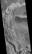
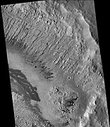
该陨击坑的许多特写照片都揭示了它的多重薄岩层,其中一些已被断层破坏,丹尼尔森坑坑底岩层可能形成于湖底[3][4][5]。
图集
[编辑]-
火星勘测轨道飞行器背景相机拍摄到的丹尼尔森陨击坑的西侧,显示了很多规则的岩层。
-
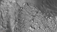
在这张背景相机图像中,可以看到丹尼尔森陨击坑的部分岩层和沙丘。
-
火星勘测轨道飞行器背景相机拍摄到的丹尼尔森陨击坑的东侧,这里有许多岩层,但几乎看不清。
-
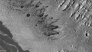
火星勘测轨道飞行器背景相机拍摄到的丹尼尔森陨击坑岩层。注:这是前面陨坑东侧照片的放大版。
-
高分辨率成像科学设备看到的丹尼尔森陨击坑的岩层,在顶部可看见尘暴痕迹。
-
在这张高分辨率成像科学设备图像中可看到许多岩层,暗色尘埃更突出了一些岩层。
-
HiWish计划下高分辨率成像科学设备看到的丹尼尔森陨击坑各岩层全景图,方框显示了下一幅图像的位置,图像中的暗黑部分是分布于平坦表面的黑色玄武岩砂。
-
显示了丹尼尔森陨击坑先前图像中断层和岩层的放大版,访图像由高分辨率成像科学设备根据HiWish计划拍摄。
-
HiWish计划下的高分辨率成像科学设备拍摄的丹尼尔森陨击坑部分区域全景图
-
HiWish计划下高分辨率成像科学设备显示的丹尼尔森陨击坑放大图。方框代表足球场大小的区域。
-
HiWish计划下高分辨率成像科学设备显示的丹尼尔森陨击坑岩层特写图,可以看到巨砾和黑色沙粒。
-
HiWish计划下高分辨率成像科学设备显示的丹尼尔森陨击坑中的岩层,在图像上部显示了尘暴痕迹。
-
HiWish计划下高分辨率成像科学设备显示的丹尼尔森陨击坑岩层彩色特写。
-
HiWish计划下高分辨率成像科学设备显示的丹尼尔森陨击坑中的岩层和岩丘。
-
HiWish计划下高分辨率成像科学设备显示的丹尼尔森陨击坑中的岩层彩色特写。
-
HiWish计划下高分辨率成像科学设备显示的丹尼尔森陨击坑岩层全景图。
-
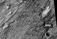
LHiWish计划下高分辨率成像科学设备显示的丹尼尔森陨击坑岩层,附带有比例尺。
-
HiWish计划下高分辨率成像科学设备显示的丹尼尔森陨击坑中的岩层和深色尘埃。
-
HiWish计划下高分辨率成像科学设备显示的丹尼尔森陨击坑底部的岩层、陨坑和土墩。
-
HiWish计划下高分辨率成像科学设备显示的丹尼尔森陨击坑底部的陨石坑近景。
-
HiWish计划下高分辨率成像科学设备显示的丹尼尔森陨击坑地面上的层状土墩。
-
HiWish计划下高分辨率成像科学设备拍摄到的丹尼尔森陨击坑地面上的岩层和深色尘埃彩色近景图。
-
HiWish计划下高分辨率成像科学设备拍摄的丹尼尔森陨击坑地面上的岩层和深色尘埃彩色近景图,在图像中可看到巨石。
-
HiWish计划下高分辨率成像科学设备拍摄的丹尼尔森陨击坑地面上的岩层和深色尘埃彩色近景图,箭头指示出断层。
-
HiWish计划下高分辨率成像科学设备拍摄的丹尼尔森陨击坑底部岩层近景,在图中可看到一些断层。
-
HiWish计划下高分辨率成像科学设备拍摄的丹尼尔森陨击坑坑底上岩层和深色尘埃的彩色近景图,在图中可看到一些小断层。
另请查看
[编辑]参考文献
[编辑]- ^ Edgett, Ken. The Martian Craters Asimov and Danielson. The Planetary Society. May 27, 2009 [2017-11-06]. (原始内容存档于2017-11-07).
- ^ Gazetteer of Planetary Nomenclature | Danielson. usgs.gov. International Astronomical Union. [5 March 2015]. (原始内容存档于2021-08-07).
- ^ Cabrol, N. and E. Grin. 2001. The Evolution of Lacustrine Environments on Mars: Is Mars Only Hydrologically Dormant? Icarus: 149, 291-328.
- ^ Fassett, C. and J. Head. 2008. Open-basin lakes on Mars: Distribution and implications for Noachian surface and subsurface hydrology. Icarus: 198, 37-56.
- ^ Fassett, C. and J. Head. 2008. Open-basin lakes on Mars: Implications of valley network lakes for the nature of Noachian hydrology.

