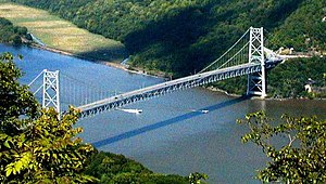
熊山大橋
外觀
| Bear Mountain Bridge 熊山大橋 | |
|---|---|
 自熊山觀望熊山大橋 | |
| 座標 | 41°19′12″N 73°58′49″W / 41.32°N 73.9803°W |
| 承載 | 2車道阿帕拉契小徑 |
| 跨越 | 哈德遜河 |
| 地點 | 紐約州科特蘭、熊山州立公園 |
| 維護單位 | New York State Bridge Authority |
| 設計參數 | |
| 橋型 | 懸索橋 |
| 全長 | 2,255英尺(687公尺) |
| 寬度 | 48英尺(15公尺) |
| 高度 | 360英尺(110公尺) |
| 最大跨度 | 1,632英尺(497公尺)[1] |
| 橋下淨空 | 155英尺(47公尺) |
| 歷史 | |
| 開通日 | 1924年11月27日 |
| 統計 | |
| 日交通量 | 17,695 (2007)[2] |
| 通行費 | 車輛1.50美元 |
熊山大橋 | |
| 地點 | 紐約州科特蘭、熊山州立公園 |
| 建於 | 1923 |
| 建築師 | Baird, Howard C.; Terr & Tench Construction Co. |
| MPS | Hudson Highlands MRA |
| NRHP編號 | 82001266 |
| NRHP收錄 | 1982年11月23日[3] |
| 地圖 | |
 | |
熊山大橋(英語:Bear Mountain Bridge)是紐約州的一座收費懸索橋,跨過哈德遜河連接威斯特徹斯特縣和羅克蘭縣。
這座橋有兩條車道(一條西,一條東),分隔兩條黃線。跨度包括橋兩側的人行道。自行車在道路上是合法的。騎自行車者可以在行人走道上行走。
參考文獻
[編輯]- 來源
- 注釋
- ^ Guide to Civil Engineering Projects In and Around New York City 2nd. Metropolitan Section, American Society of Civil Engineers. 2009: 31.
- ^ 2008 Traffic Data Report for New York State (PDF). New York State Department of Transportation. Appendix C. [February 27, 2010]. (原始內容存檔 (PDF)於2012-09-27).
- ^ National Register Information System. National Register of Historic Places. National Park Service. 2008-04-15.
外部連結
[編輯]- New York State Bridge Authority site
- Bear Mountain Bridge at nycroads.com (頁面存檔備份,存於網際網路檔案館)
- Bear Mountain Bridge at bridgemeister.com (頁面存檔備份,存於網際網路檔案館)

