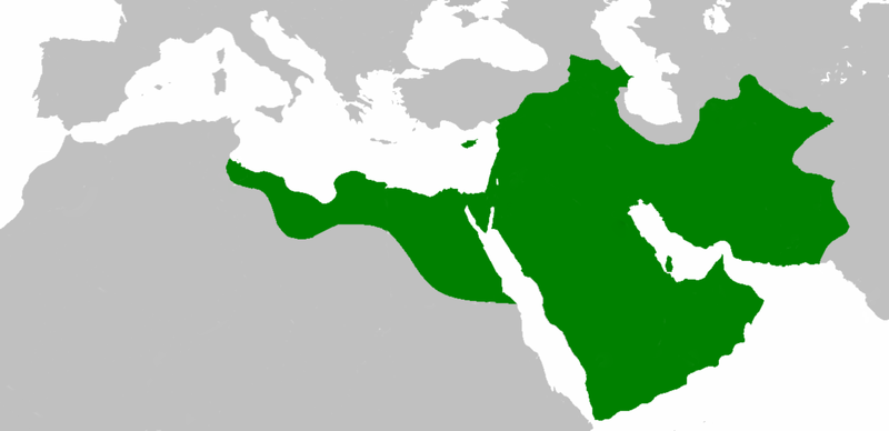
File:Mohammad adil-Rashidun-empire-at-its-peak-close.PNG
外观

本预览的尺寸:800 × 388像素。 其他分辨率:320 × 155像素 | 640 × 310像素 | 1,196 × 580像素。
原始文件 (1,196 × 580像素,文件大小:58 KB,MIME类型:image/png)
文件历史
点击某个日期/时间查看对应时刻的文件。
| 日期/时间 | 缩略图 | 大小 | 用户 | 备注 | |
|---|---|---|---|---|---|
| 当前 | 2018年12月10日 (一) 19:59 |  | 1,196 × 580(58 KB) | عبد الله | Reverted to version as of 19:41, 10 December 2018 (UTC) |
| 2018年12月10日 (一) 19:57 |  | 1,196 × 580(58 KB) | عبد الله | إزالة خطوط مزعجة | |
| 2018年12月10日 (一) 19:41 |  | 1,196 × 580(58 KB) | عبد الله | إزالة خطوط مضايقة | |
| 2017年12月12日 (二) 04:29 |  | 1,196 × 580(37 KB) | Swazzo | Reverted to version as of 23:30, 2 May 2014 (UTC) unnecessary | |
| 2017年12月9日 (六) 11:25 |  | 1,196 × 580(44 KB) | Mehrdad 12 | [[]][[Media:]]]] | |
| 2014年5月2日 (五) 23:30 |  | 1,196 × 580(37 KB) | HistoryofIran | Corrected map; regions such as Ghur was not under Rashidun control. | |
| 2012年10月19日 (五) 09:27 |  | 1,196 × 580(45 KB) | Cplakidas | correction: the Muslims had not yet established themselves beyond the Caucasus, Derbent and its environs were conquered in the 8th century | |
| 2012年7月25日 (三) 08:51 |  | 1,196 × 580(46 KB) | محک | see also:File:Age of Caliphs.png and:[http://en.wikipedia.org/wiki/Mazandaran#Post_Islamic_history] and:tapuria history book (Ibn Esfandiyar) | |
| 2012年6月17日 (日) 09:07 |  | 1,196 × 580(49 KB) | OgreBot | (BOT): Reverting to most recent version before archival | |
| 2012年6月17日 (日) 09:06 |  | 1,196 × 580(49 KB) | OgreBot | (BOT): Uploading old version of file from en.wikipedia; originally uploaded on 2010-04-25 09:06:38 by Cplakidas |
文件用途
全域文件用途
以下其他wiki使用此文件:
- ace.wikipedia.org上的用途
- af.wikipedia.org上的用途
- ar.wikipedia.org上的用途
- عثمان بن عفان
- الخلفاء الراشدون
- زيد بن ثابت
- معركة أجنادين
- الحسن بن علي
- الحسين بن علي
- بلال بن رباح
- سقيفة بني ساعدة
- حروب الردة
- الفسطاط
- خالد بن الوليد
- أبو هريرة
- أبو الأسود الدؤلي
- مارية القبطية
- عمرو بن العاص
- سلمان الفارسي
- أسيد بن حضير
- سعد بن أبي وقاص
- عائشة بنت أبي بكر
- أم حبيبة
- سودة بنت زمعة
- أم سلمة
- الزبير بن العوام
- سعيد بن زيد
- سعد بن عبادة
- عبد الله بن عمر بن الخطاب
- أبان بن سعيد بن العاص
- أبو أيوب الأنصاري
- فتنة مقتل عثمان
- القوقاز
- عبد الله بن الزبير
- أبان بن عثمان بن عفان
- أنس بن مالك
- يزيد بن أبي سفيان
- معركة اليرموك
- معركة ذات الصواري
- طلحة بن عبيد الله
- المغيرة بن شعبة
- عبد الله بن سبأ
- زينب بنت جحش
- زينب بنت خزيمة
- جويرية بنت الحارث
- صفية بنت حيي بن أخطب
- ميمونة بنت الحارث
- أبو سفيان بن حرب
- أبو ذر الغفاري
- عبد الله بن عباس
查看此文件的更多全域用途。


